
En Europe tempérée, l’essor du phénomène urbain se révèle plus tardif que dans le monde méditerranéen et répond à des dynamiques différentes. Les oppida, qui se développent à partir de la fin du IIe s. a.C., ont longtemps été considérées comme les premières villes d’Europe tempérée. Or, ces dernières décennies, cette idée est remise en question par la multiplication des opérations archéologiques. On caractérise désormais l’existence de dynamiques urbaines antérieures. Il s’agit d’agglomérations ouvertes (sans fortification massive) qui, pour certaines, éclosent d’un bout à l’autre de l’Europe près de 200 ans avant les oppida. Le projet RAPSODIE (appel à projets ESR 2019, Conseil régional de Nouvelle-Aquitaine) s’intéresse particulièrement aux plus anciens de ces sites, occupés dès le IIIe s. a.C. et dont peu sont documentés en Europe. Ces premières villes constituent des objets d’études prioritaires pour cerner l’évolution des sociétés celtiques européennes. Elles concentrent en effet plusieurs innovations majeures : 1- l’essor urbain avec un accroissement démographique sans précédent, une grande superficie d’habitat, une organisation rationalisée de l’espace (places publiques, sanctuaires, quartiers spécialisés, voierie, etc.) ; 2- une production artisanale quasi-industrielle ; 3- d’intenses activités commerciales et économiques marquées par la première apparition de la monnaie dans les échanges courants. Paradoxalement, ces agglomérations ouvertes précoces demeurent largement méconnues et peu explorées. En raison de la concentration significative de ces sites précoces dans le Sud-Ouest de la France, ce secteur constitue une zone-clé pour étudier la genèse du fait urbain en Europe tempérée. En effet, nous avons caractériser cinq sites qui présentent une phase d’occupation semblant remonter au IIIe s. a.C. (la chronologie est caractérisée par le mobilier recueilli en fouilles ou lors de prospection). Ainsi, cinq sites pouvant s’accorder à ce profil sont explorés dans le cadre du projet RAPSODIE : Lacoste, Eysses, Le Mas-d’Agenais, Eymet et La Peyrouse.
Les différents procédés employés dans le cadre du projet RAPSODIE (prospections géophysiques, études paléo-environnementales, prospections pédestres, fouilles archéologiques, LiDAR, SIG, etc.) visent à aboutir à une compréhension renouvelée des sites et de leur environnement. Ce programme répond à cinq objectifs principaux : 1- Préciser l’étendue des sites et déterminer s’ils présentent une délimitation matérialisée ; 2- Percevoir des éléments d’organisation interne ; 3- Appréhender le contexte topographique et l’environnement des agglomérations étudiées ; 4- Initier une démarche comparative pour analyser les connexions entre ces sites et les facteurs ayant favorisé leur apparition ; 5- Planifier les opérations archéologiques et confronter l’ensemble des interprétations aux données stratigraphiques issues de fouilles.
Le présent article se centre autour des premiers résultats issus des sites de La Peyrouse et de Blis, tous deux situés dans le département de la Dordogne. Bien que les explorations sur ces deux sites n’en soient qu’à leurs débuts, il s’agit de montrer comment les approches intégrées, par le croisement des méthodes, permettent de mieux préciser la nature de ces sites.
open settlements; Celtic Europe; integrated approaches; geophysical surveys; archaeology; Iron Age; Lidar; palaeoenvironment; metallurgy; urbanisation; south-west Gaul; rampart; sanctuary;
agglomérations ouvertes ; Europe celtique ; approches intégrées ; prospections géophysiques ; archéologie ; âge du Fer ; Lidar ; paléo-environnement ; métallurgie ; urbanisation ; sud-ouest de la Gaule ; rempart ; sanctuaire.
Introduction
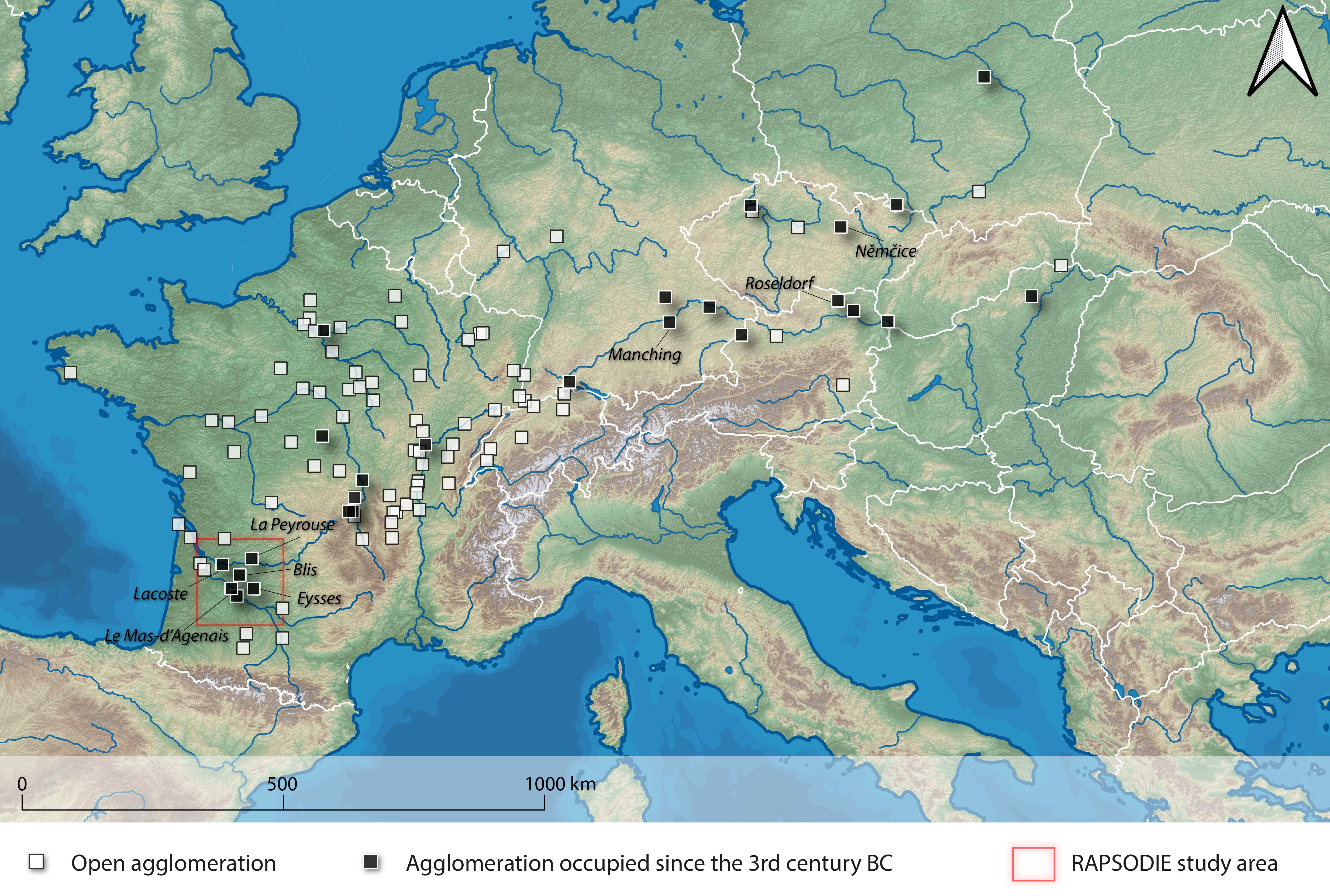
In temperate Europe, the rise of the urban phenomenon comes later than in the Mediterranean world and follows different dynamics. The oppida, developed from the end of the 2nd century BC, were long considered the first cities in temperate Europe. However, in recent decades, this idea has been challenged by the multiplication of archaeological operations. We now characterize the existence of earlier urban dynamics. These are open agglomerations (without massive fortifications) which in some cases sprang up across Europe nearly 200 years before the oppida1. The RAPSODIE project2 focuses on the oldest of these sites, occupied as early as the 3rd century BC and few of which are documented in Europe3 (fig. 1). Among the most famous sites are those of Němčice nad Hanou (CZ), Roseldorf (A), Manching (D), Nowa Cerekwia (P), Aulnat (F), Lacoste (Mouliets-et-Villemartin, F), Eysses (Villeneuve-sur-Lot, F) and La Peyrouse (Saint-Félix-de-Villadeix, F). These sites share the same profile. They are unfortified settlements that extend over several dozen hectares. The archaeological material and structures uncovered on these sites reveal intense artisanal activities (especially glass production at Němčice and Manching, iron metallurgy at Lacoste). Imports of manufactured goods and raw materials (such as amber from the Baltic or glass from the Near East4), as well as the sometimes distant origin of coinage, testify to the liveliness and scope of commercial activities. These changes refer to a basic trend common to sites several hundred – or even thousands – of kilometers apart. It is essential to explore in greater detail the European concordance of these phenomena.
These first cities are priority targets for study in order to understand the evolution of European Celtic societies5. They concentrate several major innovations: 1- the urban boom with an unprecedented demographic growth, a large settlement area and a rationalized spatial organization (public squares, sanctuaries, specialized neighborhoods, roads, etc.); 2- a quasi-industrial artisanal production; 3- intense commercial and economic activities marked by the first appearance of coins in current exchanges6.
Paradoxically, the Celtic open settlements remain largely unknown and poorly explored. This is mainly due to the lack of visible traces in the landscape (absence of monumental fortifications, unlike the oppida, perishable constructions, etc.). The open agglomerations are therefore difficult to locate. Moreover, these large sites extend on tens of hectares: when excavations are carried out, they only cover limited areas that are often minimal compared to the overall size of the sites. In order to apprehend these sites and complete the pieces of the puzzle, appropriate methods must be used. The various methods used in the RAPSODIE project (geophysical surveys, paleo-environmental studies, pedestrian surveys, archaeological excavations, LiDAR, GIS, etc.) aim to compensate for this limited vision, in order to achieve a renewed understanding of the sites and their environment.
In France, this kind of integrated approach was introduced in the 1980s to better define Iron Age sites, notably at Levroux7. Research carried out in eastern France by teams from the Universities of Burgundy and Franche-Comté should be highlighted: for example, at Authumes (Saône-et-Loire) and Mirebeau-sur-Bèze (Côte-d’Or)8. They have also been developed within the framework of the ANR CELTECOPHYS program9, where they provide an understanding, over large areas, of the organization of artisanal structures in the Iron Age10. On the scale of Central Europe, geophysical methods have been applied in particular to the agglomerations of the 3rd-2nd centuries BC in Austria at Roseldorf11 and Haselbach12, or in the Czech Republic at Němčice13. Over several dozens of hectares, they have provided an extensive view of the occupation through mapping of magnetic anomalies induced by the presence of archaeological remains.
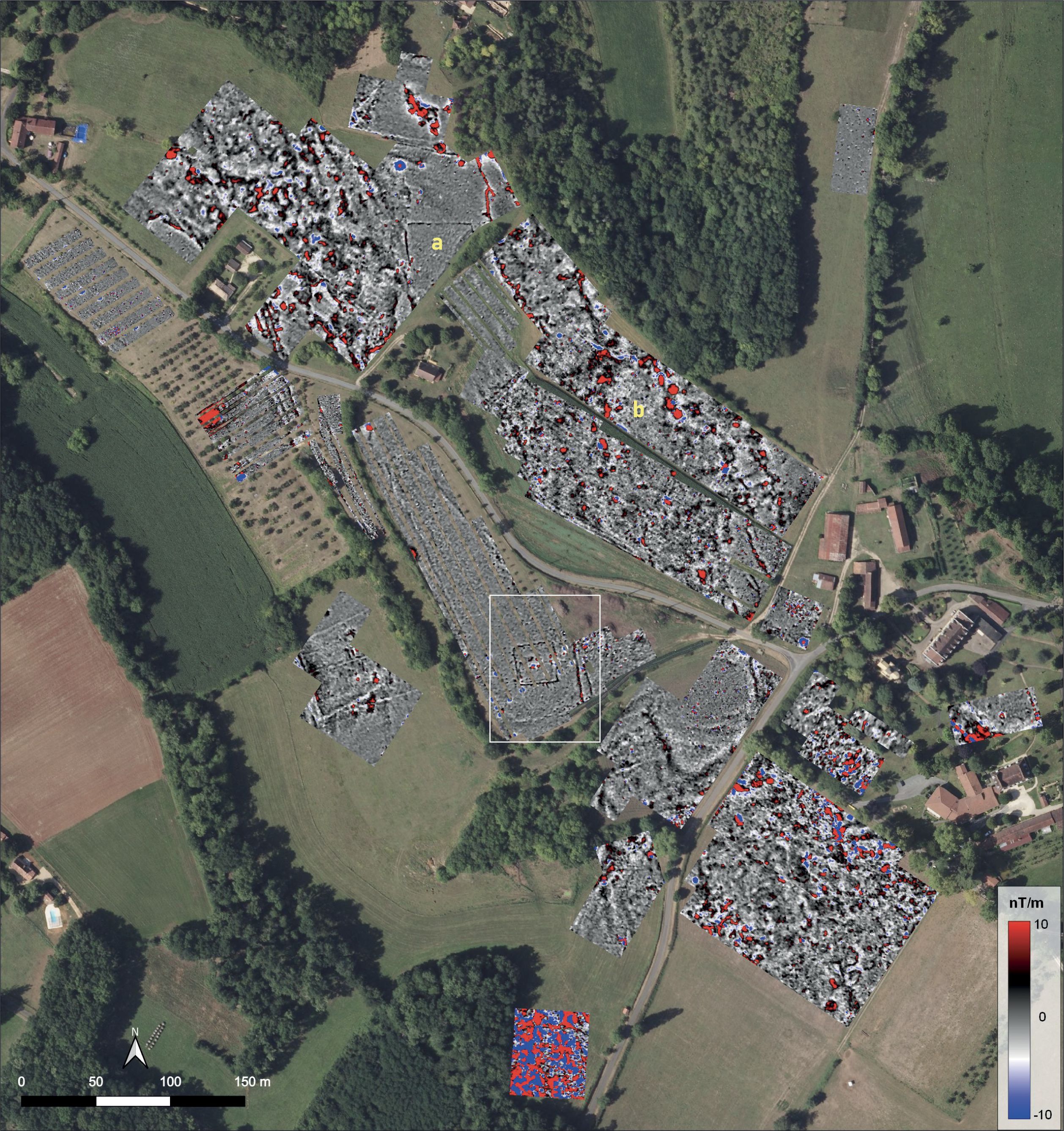
The scope of the results encourages the spread of these extensive and non-invasive approaches. Because of the significant concentration of open agglomerations in southwestern France (fig. 1), the region of Aquitaine constitutes a key area for studying the genesis of the urban phenomenon in temperate Europe. Indeed, some sites show an occupation phase that seems to date back to the 3rd century BC.14 Thus, five sites are investigated in the framework of the RAPSODIE project: Lacoste (Mouliets-et-Villemartin), Eysses (Villeneuve-sur-Lot), Le Mas-d’Agenais, Blis (Eymet) and La Peyrouse (Saint-Félix-de-Villadeix).
This program has the following main objectives:
- To specify the extent of the sites and to determine if they have a materialized delimitation;
- To recognize elements of internal organization;
- To understand the topographical context and the environment of the studied settlements;
- To initiate a comparative approach in order to analyze the connections between these sites and the factors that favored their appearance;
- To plan the archaeological operations and to confront the whole of the interpretations with the stratigraphic data resulting from the excavations.
This paper focuses on the first results from the sites of La Peyrouse and Blis, both located in the Dordogne department. Although explorations on these two sites are still in their infancy, the aim is to show how integrated approaches, through the crossing of methods, allow us to better specify them.
La Peyrouse (Saint-Félix-de-Villadeix). An artisanal agglomeration and its environment
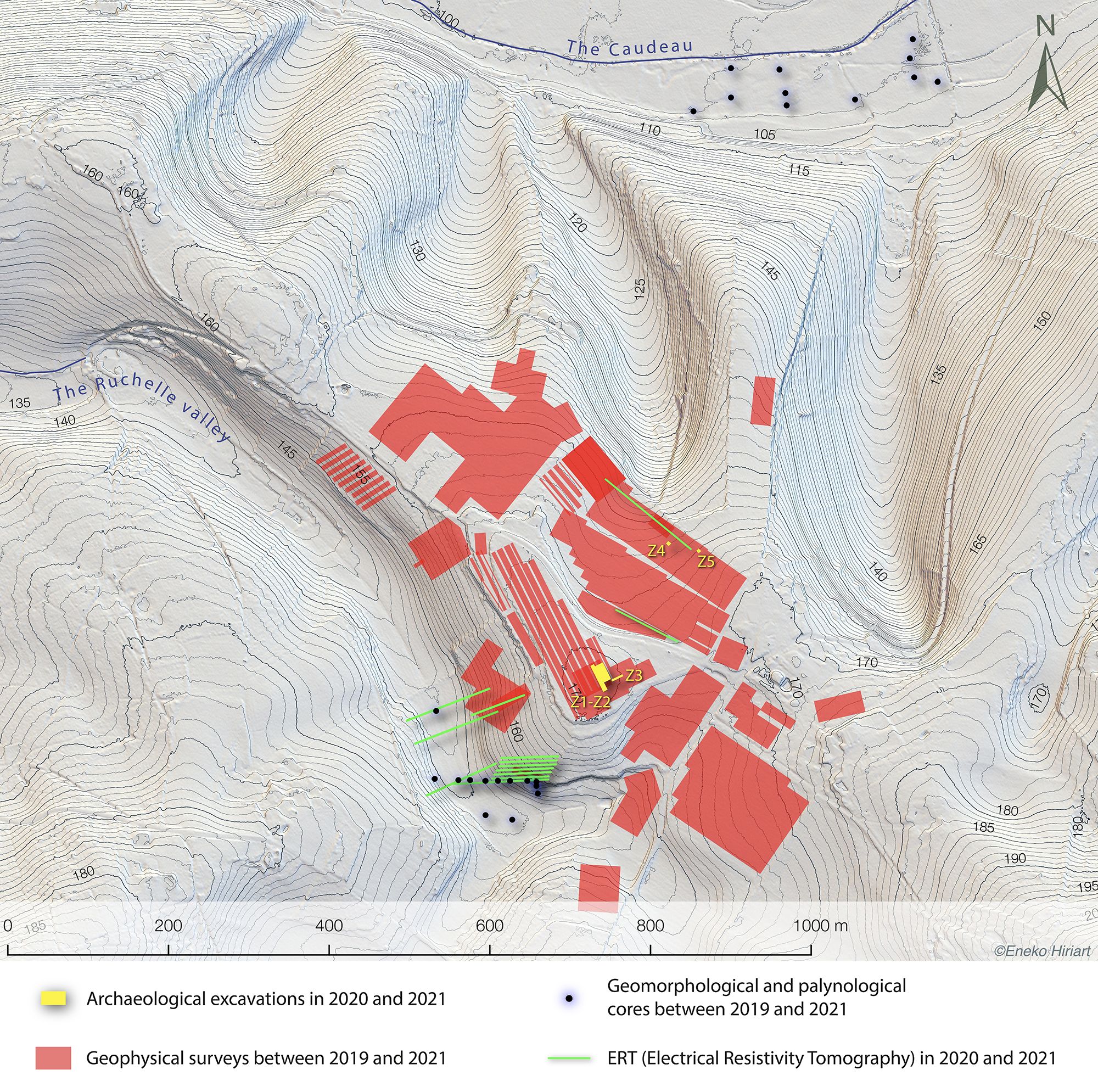
The agglomeration of La Peyrouse is located on the right bank of the Dordogne river, 12 km away. The site occupies a vast limestone plateau (between c. 150 m and 170 m NGF) delimited by the valley of the Caudeau to the north and by the valley of the Ruchelle to the south (fig. 2). There are several water points in the immediate vicinity (notably, in the southern valley, a well and an underground aqueduct). A cave has been recorded on the southern slope of the plateau. Research conducted since 2014 has not revealed the slightest trace of visible fortification.
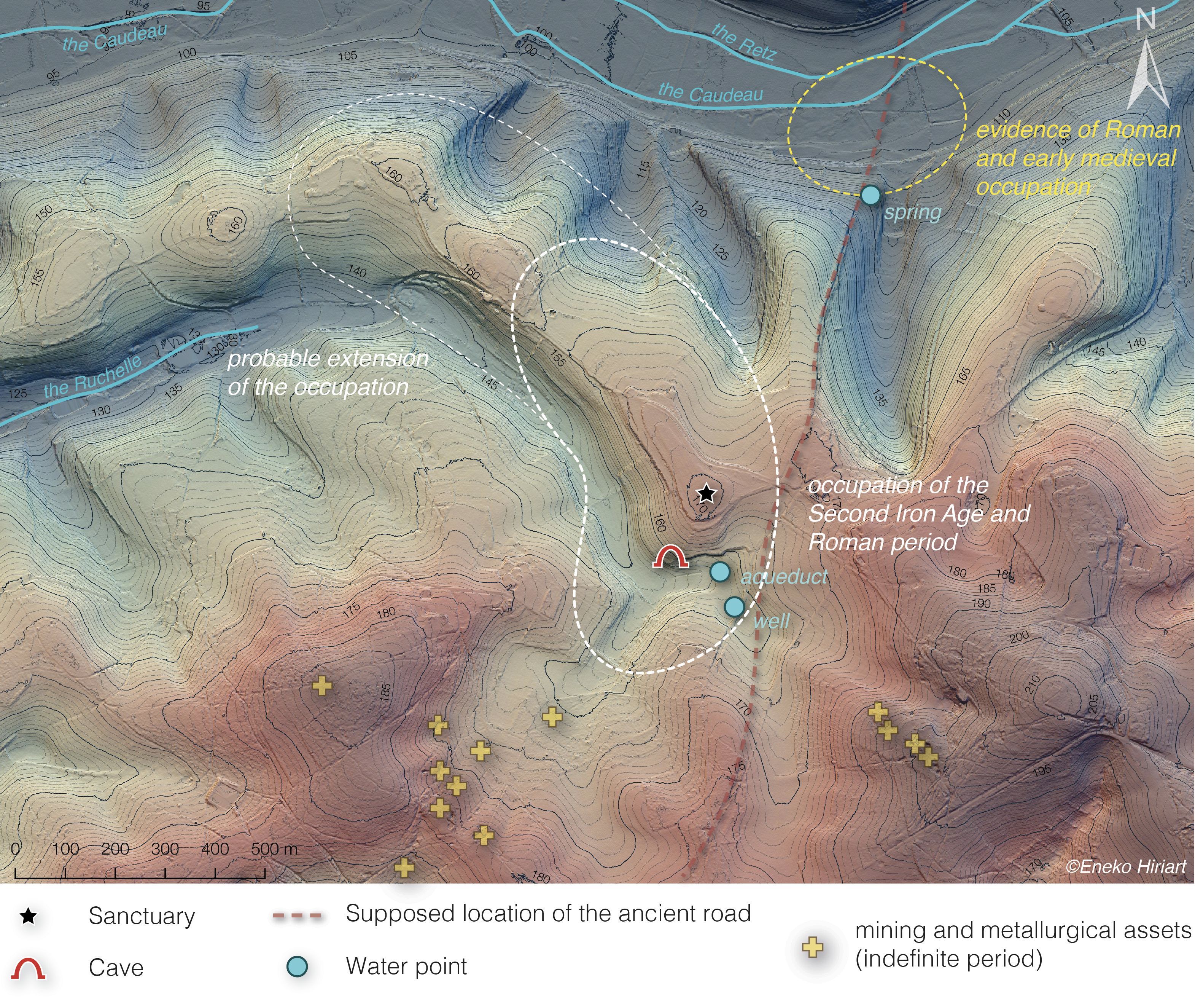
The site probably owes its location and economic development to two main factors: firstly, the existence of a major north-south land route15 (Périgueux to Agen) which borders the site, and secondly, the significant iron ore resources in the surroundings.
Since 2019, La Peyrouse is being explored in the framework of the RAPSODIE project and the PCR La Peyrouse16(fig. 3). These projects aim to develop several approaches to address targeted issues related to the organization of the site and the evolution of its environment.
The following paragraphs provide an overview of the main research we are conducting on several (strategic or unknown) areas of the site. We will focus here on selected sectors, located in the near and far surroundings of the agglomeration. The overview will follow a geographical and thematic path:
- A first section focuses on the results of the pedestrian surveys, which provide invaluable data for characterising the occupation;
- We will then discuss the mines and iron metallurgy, which have been recognised in a vast area surrounding the site;
- Afterwards, we will move to the south of the plateau. Several cross studies have targeted the cave and the valley in order to evaluate the archaeological potential of the sector and to understand its sedimentary dynamics;
- Then, moving to the north of the plateau, in the alluvial plain of the Caudeau, we detail the palaeo-environmental approaches that have been carried out;
- A section is dedicated to the geophysical surveys – in particular magnetic surveys – which have covered a large part of the site (fig. 3);
- Finally, we conclude with a presentation of the first results of the archaeological excavations. These have targeted several strategic sectors, and more particularly the Celtic sanctuary.
Pedestrian surveys and occupation dynamics
The surveys carried out by C. Chevillot and the ADRAHP team since 2014 have revealed remains spread over several hectares whose chronology extends from the Paleolithic to the modern period17. Two main phases of occupation emerge, one corresponding to the La Tène C-D (3rd-1st century BC), the other to the early Roman Empire (1st-2nd century AD).
Occupation from the early Roman Empire (1st-2nd century AD)
There are numerous finds from the early Roman Empire on the plateau, showing a continuity of occupation with the Latenian period. In particular, there are about more than forty Roman coins, mostly from the 1st and 2nd centuries AD.18 The corpus of ancient glass is composed of nearly 300 fragments. A large number of fragments of tegulae are also documented.
Ancient remains have been also identified on the northern periphery of the plateau, on the left bank of the Caudeau river (fig. 2).
The Celtic agglomeration (3rd-1st century BC)
The Latenian occupation is the most significant in time and area. It has been recognised on a large part of the plateau as well as on the southern valley. The older remains of the Iron Age seem to date back to the end of the 4th century BC (La Tène B1). However, according to the majority of the archaeological material discovered on the surface, the site was most densely inhabited between the 3rd and 1st centuries BC.
Among the abundant material attributable to this phase, it is worth highlighting:
- numerous glass bracelets and beads dated to the 3rd, 2nd and 1st centuries BC;
- numerous iron objects (kitchen utensils, craft and agricultural tools, hardware…);
- common La Tène C-D ceramics;
- an abundance of fauna (mainly pork, beef and ovicaprids);
- more than 2000 amphora fragments found19 (mainly Dressel 1A);
- more than a hundred coins whose chronological facies (mainly between the middle of the 3rd century BC and the 2nd century BC) refers to an early period of Celtic coinage20.
The craft industry occupies a predominant place within the activities characterised on the site. The importance of residues linked to iron metallurgy21 (reduction and forge slag) and, more occasionally, non-ferrous materials (copper alloys, gold, silver) should be emphasised. It is also worth noting the discovery of a glass waste that the analysis could link to the work of the Latenian glass22.
Remains from the Second Iron Age have also been recognised in the vicinity of the site. In particular, we note the discovery of more than a hundred fragments of Dressel 1A amphorae and a probable iron reduction workshop at La Vernelle, 4 km west of La Peyrouse.
In terms of its morphology23, chronology and material discovered, the site of La Peyrouse falls into the category of open agglomeration that concentrates important artisanal and commercial activities.
Mining and iron metallurgy
The craft industry occupies a central place within the activities characterised on the site. Amongst these, the ferrous wastes24 underline the importance of the activities related to iron metallurgy. All phases are documented, from the ore extraction to the reduction and forging work. The exploitation of iron certainly played a decisive role in the development of the La Peyrouse site in the Celtic period.
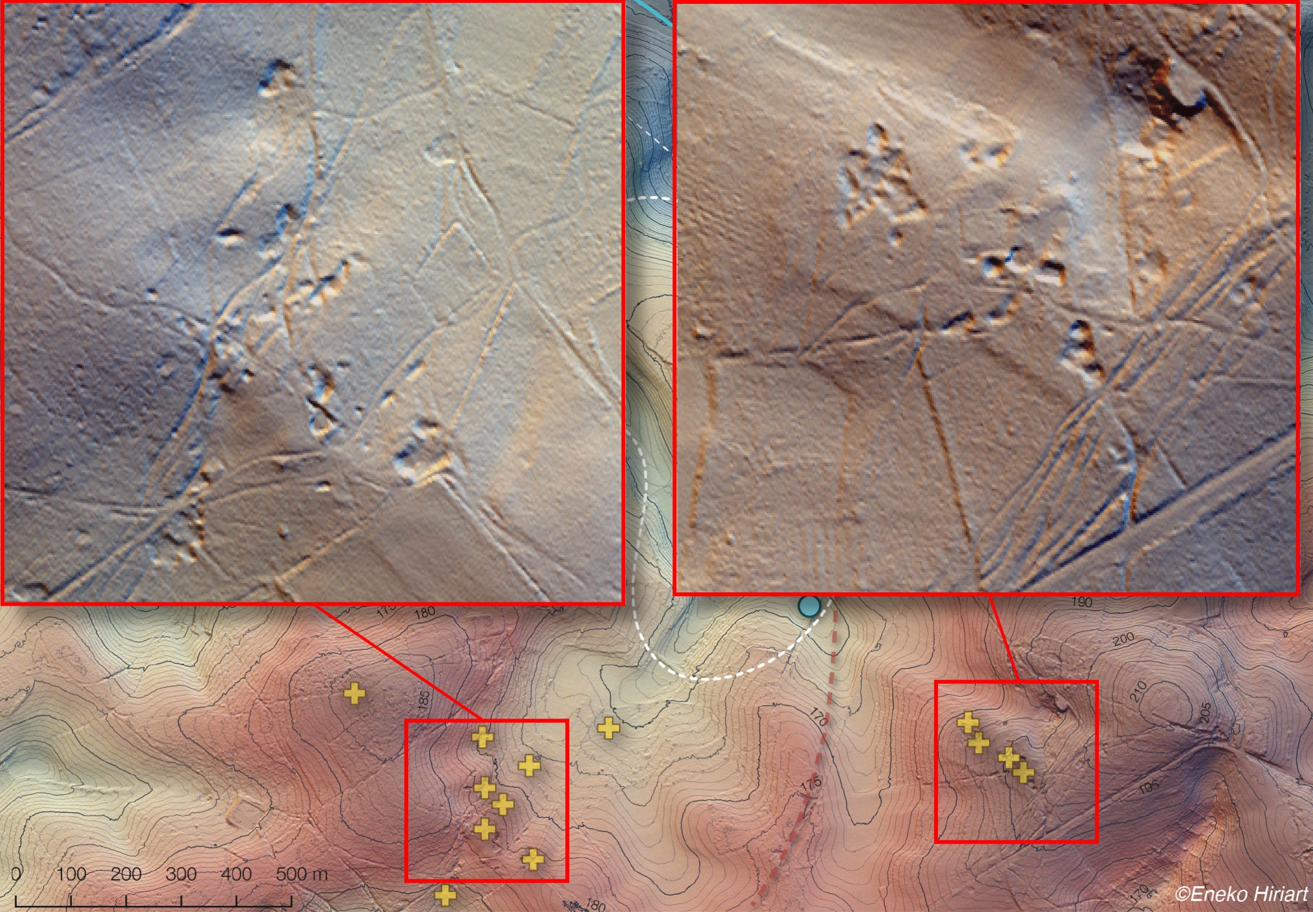
The LIDAR survey analysis and pedestrian prospecting revealed the existence of several extraction pits in the forests surrounding the site (fig. 4).
The research carried out by A. Beyrie and J.-M. Fabre in 2021 made it possible to draw up an initial inventory of the mining and metallurgical assets in the neighborhood of La Peyrouse25. 21 sites have been identified within a 4 km radius of the site (fig. 2). These data depict an area where iron resources were actively sought after over a long period of time (from Protohistory to the 20th century). The chronology of the mining structures is not well established. This is why the next operations will aim to specify the chronology of the mining sectors that have been identified. Nevertheless, it already appears that the La Peyrouse agglomeration was located in the heart of a region favourable to iron and steel activity26. It had a particularly advantageous environment with mineral resources.
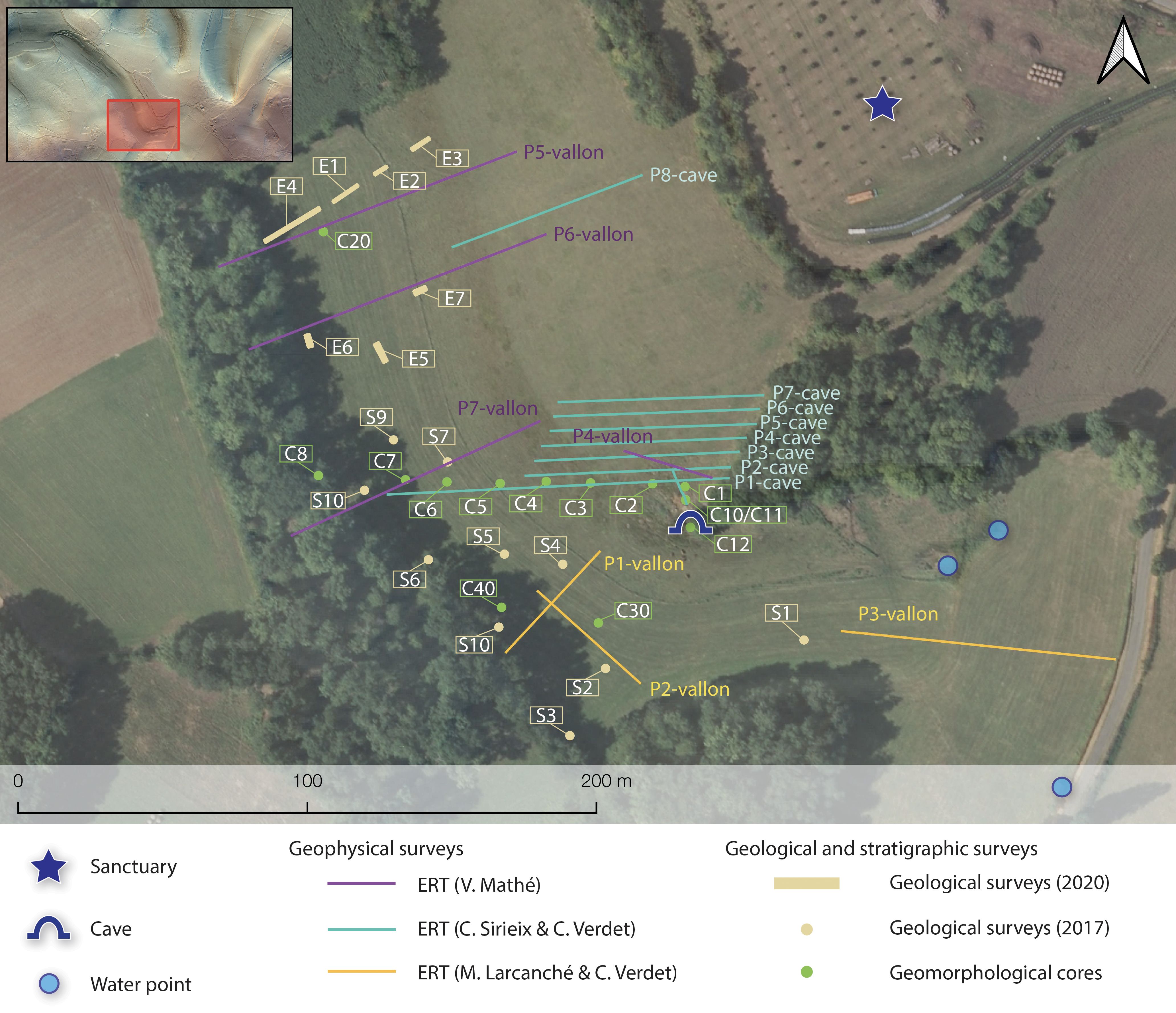
The southern valley: the cave and the sedimentary deposits
The Ruchelle valley, to the south of the plateau on which the main occupation of the site is located, has been the subject of numerous cross-studies (fig. 5). Indeed, this sector raises several questions. In particular, since we have documented a cave there and discovered levels of the Second Iron Age at a depth of nearly 3m. The coupling of several geophysical, geomorphological and stratigraphic studies aims to understand the sedimentary dynamics of this area and to evaluate its archaeological potential.
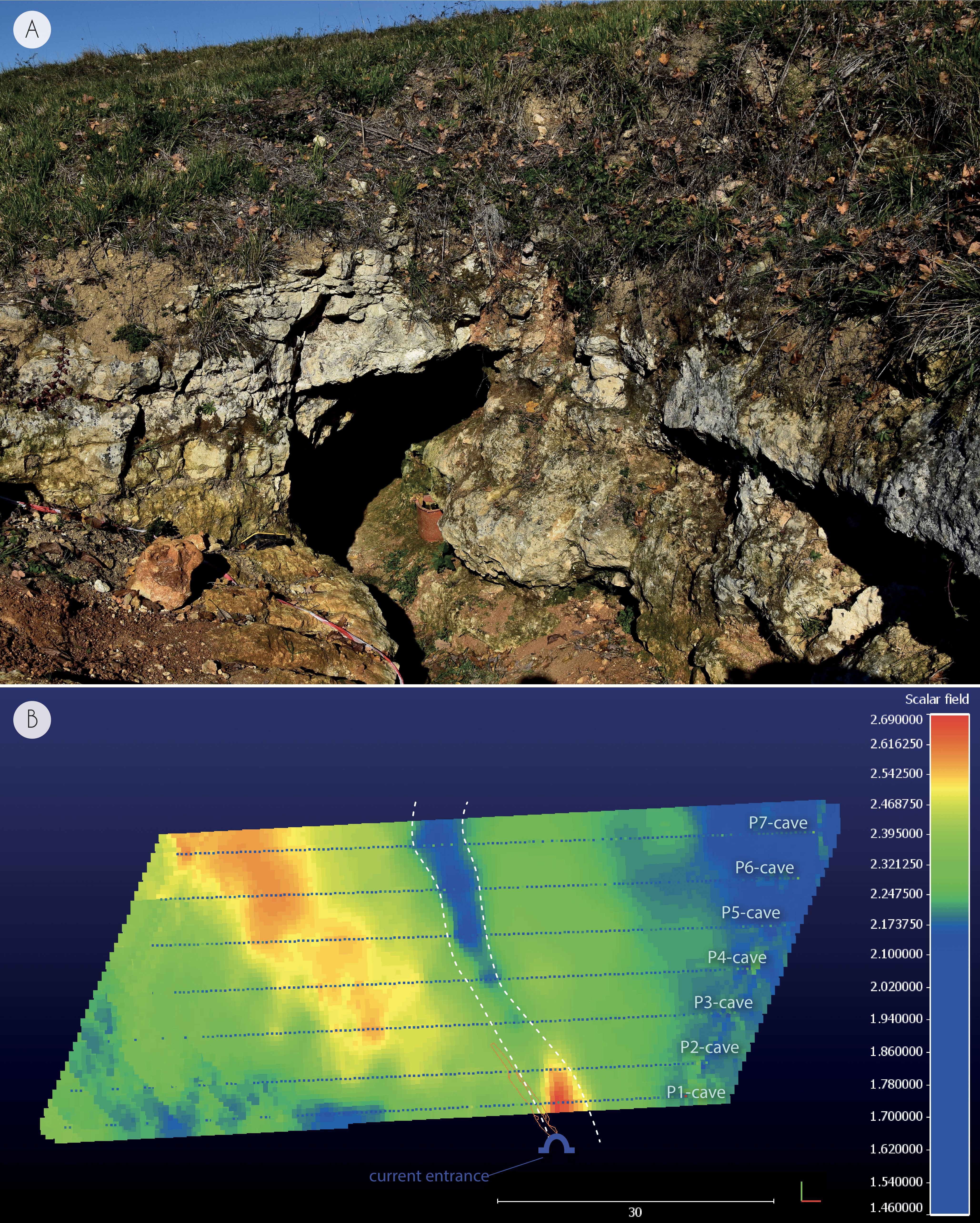
The cave
The presence of a cave on the southern side of the plateau remains a question mark (fig. 6, A). It is located in the very heart of the Celtic settlement of La Peyrouse. One could therefore envisage a strong archaeological potential, especially as shards of amphorae and ceramics have been discovered there27. To date, the extension of the cave remains unknown (it is blocked beyond 8 m). Before considering a disobstruction or an archaeological exploration of the cave, it was necessary to know if its geometry could have allowed human activities. We thus wished to apprehend its depth, its volume and if the sedimentary fillings have a large spatial extension. Through geophysical acquisitions using electrical resistivity tomography (ERT), C. Sireix and C. Verdet sought to evaluate the continuity and to specify the potential extent of the cave. Eight ERT profiles were carried out perpendicular to the cave28 (P1 to P8, fig. 6, A). Each of these profiles reveals a low resistivity anomaly in the continuity of the cave, which could be consistent with the presence of a sealed cavity. Based on an interpolation of these data, 3D modelling suggests that the cave could extend over a length of more than 30 m (fig. 6, B). The possible continuity would have to be confirmed by an operation to clear the cave.
These observations were complemented by two core samples taken inside the cave (C10 and C11). These revealed a thin layer of sterile clay sediment, with no evidence of anthropisation29.
The Ruchelle valley
In the middle of the Ruchelle valley, immediately in front of the cave, geotechnical surveys targeted the southern valley of La Peyrouse (E1 to E7 in 2020; S1 to S10 in 2017). This portion of the valley corresponds to the head of the Ruchelle stream watershed, which feeds the Caudeau river30. While some test pits were negative (without archaeological structures), several of them (E1, S2, S4 and S9) revealed the presence of silty levels rich in charcoal and material from the Second Iron Age (amphorae, ceramics, fauna, slag, charcoal, coins) at a depth of between 2.5 m and 3.5 m31.
Such a large amount of sedimentation over the last two thousand years raises questions. It seems all the more surprising given that we are at the head of a valley. Eleven geomorphological cores were taken by R. Steinmann and S. Colin in 2020 to better understand the sedimentary processes32. The corings, which notably yielded a Latenian sherd at 2.2 m below the present surface (C7), suggest that the significant sedimentation is certainly due to colluvium33. These could be the result of denudation of the slopes due to agricultural and/or artisanal activities. It is this hypothesis – more particularly the relationship with iron mining activities – that is currently favoured by geomorphologists.
In parallel with these studies, several electrical resistivity profiles were carried out (P1 and P2-vallon; fig. 5) to complete our understanding of the valley layout and bedrock depth. These acquisitions will be used to support excavations, which aim to characterize the archaeological potential of the sector34.
A first paleoenvironmental approach
The research carried out in the Ruchelle valley has revealed a significant accumulation of colluvial material, which seems to reflect intense anthropisation and environmental exploitation. Although these sequences reveal a filling of exclusively detrital origin, no organic sequence with a high potential for palaeoecological recording has been observed. The question of the environment remains central to the understanding of the site. In order to improve our understanding of the link between the evolution of the environment and that of human occupation, it seemed essential to look for organic sequences suitable for palynological records35.
This led to investigations being directed towards the north of the site and the Caudeau River. On this alluvial plain, organic clogging has already been verified about ten km downstream in the context of previous research36. The studies carried out in 2021 aimed to assess the clogging of the Caudeau valley and to carry out a pollen diagnosis of the deposits. 11 spot corings (manual and mechanized) were performed (fig. 3). The aim was to test areas and collect organic sequences suitable for a pollen record. These core samples did not reveal any significant thicknesses of organic deposits. The first results are therefore not yet sufficiently eloquent. One sequence, probably related to the medieval or modern period, suggests an environment of cultivated plots and grazed meadows. The plantations appear to be varied: cereals, including rye (Secale), fruit trees (chestnut, walnut, oliver) and textile plants (hemp)37.
Further field surveys will therefore be necessary to try to obtain more relevant results. The aim is to identify, over a long period, the phases of evolution of the landscape around La Peyrouse. In particular, we are wondering what impact the installation of the Celtic town may have had on the environment (what kind of deforestation? Which species were cultivated?).
Geophysical surveys on the site of La Peyrouse
Strategy and geophysical methods
The first geophysical surveys were aimed at mapping and identifying buried structures over a large area. Magnetic prospection was chosen because it is the most effective method to detect all types of anomalies and to distinguish different kind of remains such as pits, ditches or kilns38. To that end, a Ferex gradiometer (Foerster) was used. It consists of four probes, each 0.5 m apart that simultaneously record four profiles in a single field pass. Its sensitivity of 0.3 nT/m allows to cover more than 1 ha per day and is sufficient to detect trenches dug into a limestone substrate39, limestone walls40 and kilns or fireplaces41.
After an initial comprehensive approach, some anomalies were studied in greater detail using electrical prospecting in order to facilitate their interpretation. A pole-pole array provides the construction of a resistivity map at a depth of about 0.5 m with a RM85 resistivity meter (Geoscan Research). The measurements were made in a square grid of 0.5 m. Eventually, the same anomalies were intersected with the ERT to obtain a vertical view. A Terrameter LS resistivity meter (Abem) in dipole-dipole configuration was used to obtain the equivalent of a 3 m deep profile.
Main geophysical results
A lot of magnetic anomalies are detected over 12 ha42 (fig. 7). The uniqueness of the results depends on the area. In some places, identification and interpretation of the anomalies are challenging. Few of them are from modern disturbances (electrical pole, fences). Having in mind the topography of the terrain, some of them could be interpreted as natural (geological relief, diaclases). Among the anomalies that are probably of archaeological origin, a three-sided enclosure open in the southern part (fig. 7, A, a) can be seen in the northern part. It is similar to some examples discovered in other Celtic settlements (Barzan or Aiffres43), but their function remains unclear (public space?). Further down, large and strong magnetic anomalies can be observed (fig. 7, A, b). These anomalies could be seen as kilns in regard to the abundance of objects and artisanal waste collected on the ground44.
The highest point of the site is currently covered with truffle trees. The magnetic contrast here is very strong, which facilitated the reading and interpretation of the archaeological remains. The quality of the signal allowed the discovery of several groups of four anomalies, each forming square buildings of about 2.50 m to 3 m side (fig. 8, A, c). These small structures could be granaries attached to piles.
The most notable remains is a square enclosure of about 25 m side (fig. 8, A). It is bordered by linear anomalies whose geometry and signals suggest ditches45. They delimit an internal area of about 700 m². Internal features are characterized by punctate magnetic anomalies (pits). Among the most notable pit is a group of intense magnetic anomalies clearly visible in the center. In addition, the eastern part features two anomalies with high magnetic intensity, which are suggesting the existence of an entrance in this area. Finally, the southern and western trenches are lined on the inside by narrow linear anomalies that break off in the southwestern corner.
An electrical survey recorded the enclosure (fig. 8, B) and an ERT was carried out in the southeastern part (fig. 8, C). The ditches are linear anomalies with low resistivity, more or less apparent depending on the side. This low contrast was sufficient to reveal an interruption on the east side: it confirms an entrance here (fig. 8, B, f). The ERT indicates a very low sediment thickness and the bedrock is actually close to the surface. The southern and eastern ditches are preserved up to 0.70-0.80 m deep. The section also intersects two large ditches discovered about 10 m east from the enclosure. Both are preserved to a depth of about 1 m. They are adjacent to a high resistivity anomaly of about 5 m wide. The vertical image suggests here the existence of a road consisting of an undulating strip and two adjacent ditches. It could have been an important road axis structuring the agglomeration of La Peyrouse.
The richness and quality of the geophysical results show the relevance of geophysical prospection. In fact, knowledge about this agglomeration has increased thanks to the discovery of new remains. Even during the first campaigns, the maps showed the existence of a settlement that extended over more than 10 ha and was partially structured around a space for craft activities and a religious complex. A multi-method geophysical approach provided a first plan and vertical view of the structure. Its plan allows a comparison with a series of sanctuaries known in Celtic Europe46. However, this presumed cultic function had to be complemented by more precise functional and chronological data, which were generally lacking at the end of the geophysical surveys. Therefore, an archaeological excavation based on geophysical maps was justified to confirm the existence of a sanctuary in the agglomeration of La Peyrouse.

Subsurface imaging using radar techniques
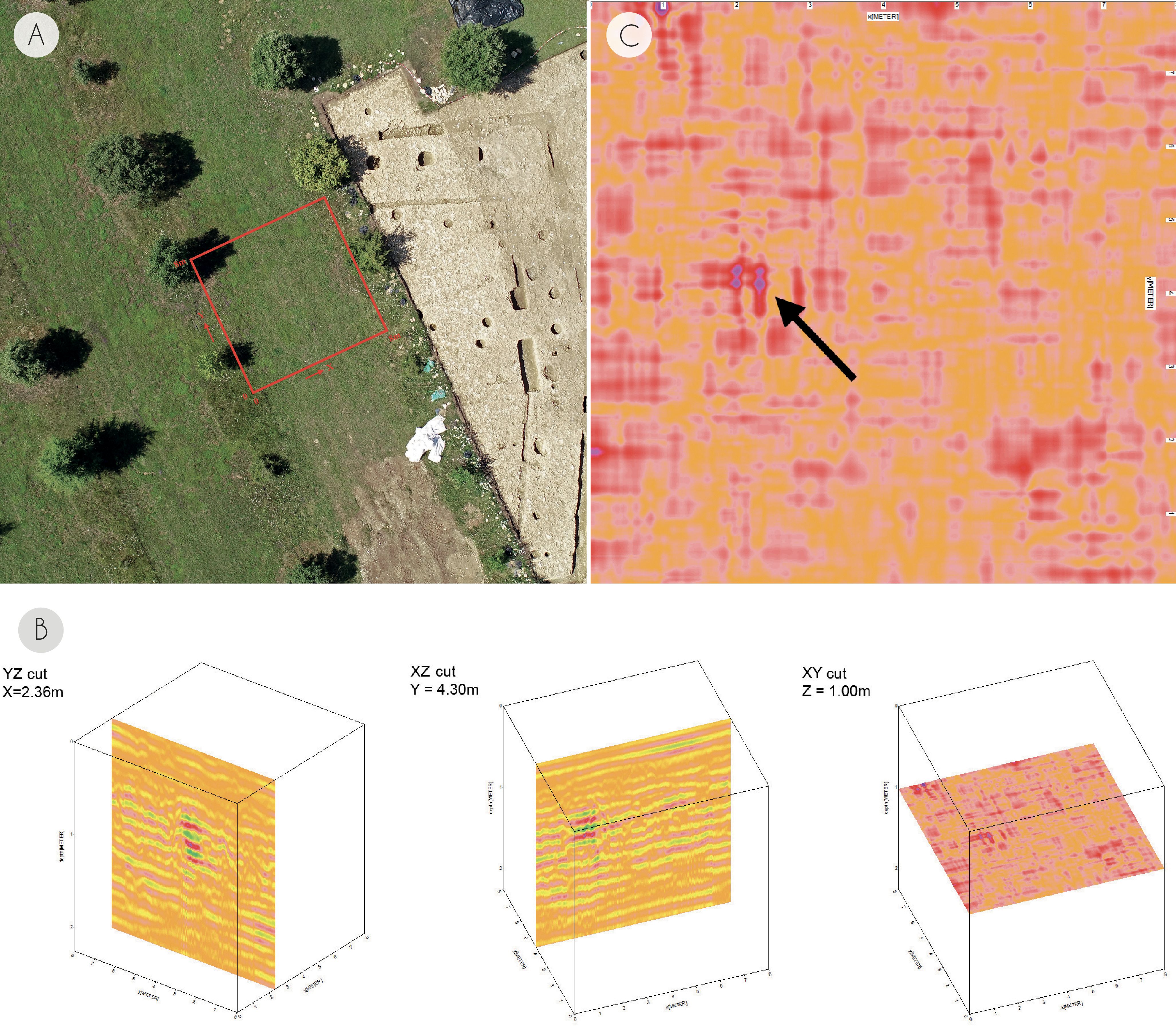
Within the framework of the archaeological operations carried out at La Peyrouse, a collaboration was set up between archaeologists and astrophysicists of the LAB (Laboratoire d’Astrophysique de Bordeaux, Université de Bordeaux). Within this framework, geophysical prospecting by georadar was carried out. These acquisitions focused on the center of the sanctuary, where magnetic surveys have revealed a set of four sub-circular anomalies with two pronounced poles. From an archaeological point of view, the aim is to document this central and strategic part of the sanctuary. We are looking for complementary data to better orientate the archaeological excavations that will target this sector in 2023. Radar techniques have been used for many years to probe subsurface structures down to tens of meters. They are especially efficient in dry environments, being used for archeological and hydrological prospecting47. From the perspective of astrophysical research, the goal is to develop a droneborne georadar for planetary exploration48. These new droneborne systems could also be of interest in the near future for archaeological prospecting: La Peyrouse is being used as a test site because it offers the opportunity to compare the geophysical acquisitions with exact stratigraphic data from the excavations.
In the first stage, subsurface data were acquired using a classical Ground Penetrating Radar (GPR). They will be used as reference for the calibration of the droneborne radar, but firstly already provide interesting results revealing buried features in the sanctuary. We used a SIR3000 system from GSSI together with a wide range 400 MHz antenna, in order to map a 8 by 8 m area in the central part of the sanctuary49.
Fig. 9, A shows the location and extent of the studied are. We acquired one GPR profile every meter in each direction, which makes a total of 18 profiles. The Reflex3DScan software by Sandmeier Geophysical Research [https://www.sandmeier-geo.de/index.html] was used to perform basic processing of GPR profiles: static correction, background removal, time to distance conversion. Using bilinear interpolation, a 3D data cube of radar reflectivity was produced, extending over 8×8 m in surface and down to 2 m in depth.
Fig. 9, B shows three cuts in the GPR data cube, the X-Y plane being the 8×8 m probed surface and Z representing the depth under the surface down to 2 m. We note the presence of several conductive anomalies (in red), whose location is consistent with those revealed by the magnetic surveys (fig. 8, A). These could correspond to the location of pits dug in the less conductive limestone bedrock. One can also observe a very strong reflector at X=2.36 m, Y=4.30m, Z=1.0 m, which very likely corresponds to a buried feature made of metal (only very conductive materials produce such high reflectivity radar signals). Fig. 9, C presents a zoom of a cut at the depth Z=1.0m, the arrow showing the high reflector with four strong scatterers located at the corners of a square, possibly the corners of a buried metal artifact(s). Future prospecting will be conducted using the droneborne system with a higher frequency 900 MHz antenna in order to better reveal the shape of the archaeological structures and buried features.
The archaeological excavations
The sanctuary of La Peyrouse
The archaeological excavations carried out by E. Hiriart from 2020 onwards targeted the quadrangular building revealed by the geophysical surveys, in the middle of a truffle tree plantation50 (fig. 10). The structure, located on the highest point of the site (170 m NGF), has a layout similar to the Iron Age sanctuaries documented in Gaul (e.g. Gournay-sur-Aronde, Corent or Tintignac). Common features include the quadrangular ditched structure (c. 27 m on a side), a central layout and the east-facing entrance. The excavations targeted the eastern part of the building in order to verify the religious function of the building and to collect chronological elements.
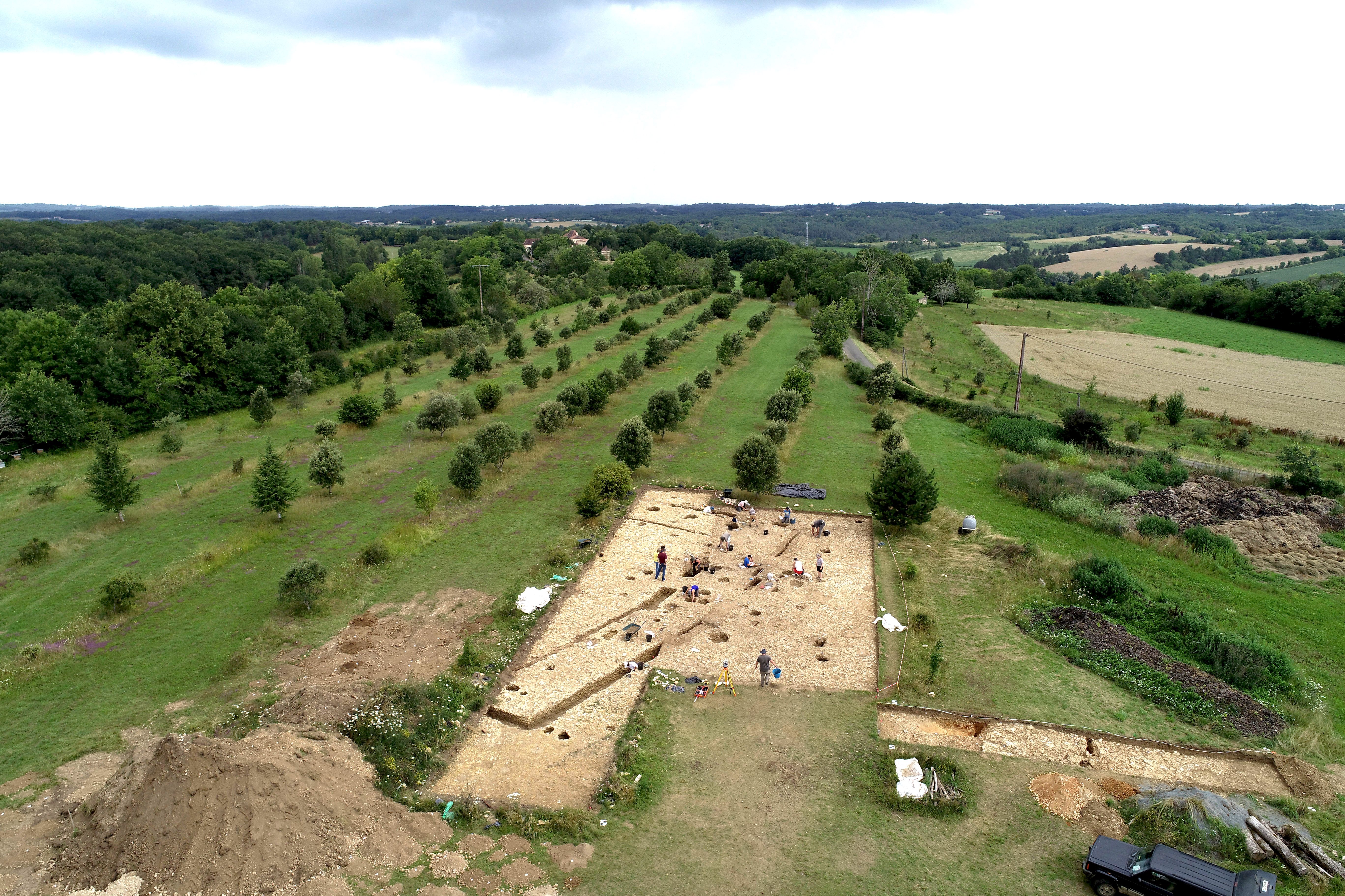
The limestone substratum lies some 20 cm below the present soil. Due to erosion, no occupation level could be observed. Several structures (ditches, pits, post holes) constituting the building were uncovered, all of which were dug into the bedrock. A superposition of geophysical acquisitions and an orthophotograph of the excavations illustrates the perfect complementarity of these data (fig. 11).

The quadrangular enclosure of the sanctuary was revealed at both ends of the test pit, on its northern, southern and eastern sides (fig. 12). The ditch is characterised by a U-shaped profile, with a preserved depth of 60-70 cm. All observations indicate that it corresponds to a palisade foundation ditch. In the inner space of the building and parallel to the main enclosure, two straight trenches of shallow depth (10-20 cm) allowed for a lighter wall.
Two large pits (F3 and F9) are reported on either side of the passageway to the interior of the building. These deep rectangular structures, with vertical walls and flat bottoms, correspond to large post holes, and represent the anchorage of the monumental entrance porch of the sanctuary (fig. 12).

The threshold is also framed by a less imposing porch, marked by four post holes (F228, F246, F212 and F233), which corresponds to a different architectural state.
Several postholes, some of them very large, are documented within the enclosure. For example, to the north of the pit, three large postholes (F12, F14 and F204) are noted, which appear to be related to a gallery arrangement.
The lack of soil levels makes it impossible to establish stratigraphic relationships between the various structures. The archaeological material refers mainly to a period between the middle of the 2nd century and the middle of the 1st century BC and does not allow a typo-chronological phasing to be established. Although the presence of different architectural states is confirmed, they cannot be precisely identified.
The excavations on the sanctuary have yielded an abundance of archaeological material which differs from that usually collected during pedestrian prospecting of the plateau (settlement area). Among the “exceptional” remains, we should mention the discovery of miniature vases, weapons (sword, shield orle, lance heel), arrowheads, mutilated pieces, fragments of human skulls, etc. These various clues closely resemble the furniture assemblage of other sanctuaries in the Celtic world. All the evidence gathered during the archaeological excavations carried out in 2020 at La Peyrouse confirms the building’s cult vocation. This constitutes the first discovery of its kind in Aquitaine, where no Celtic sanctuary has ever been found before.
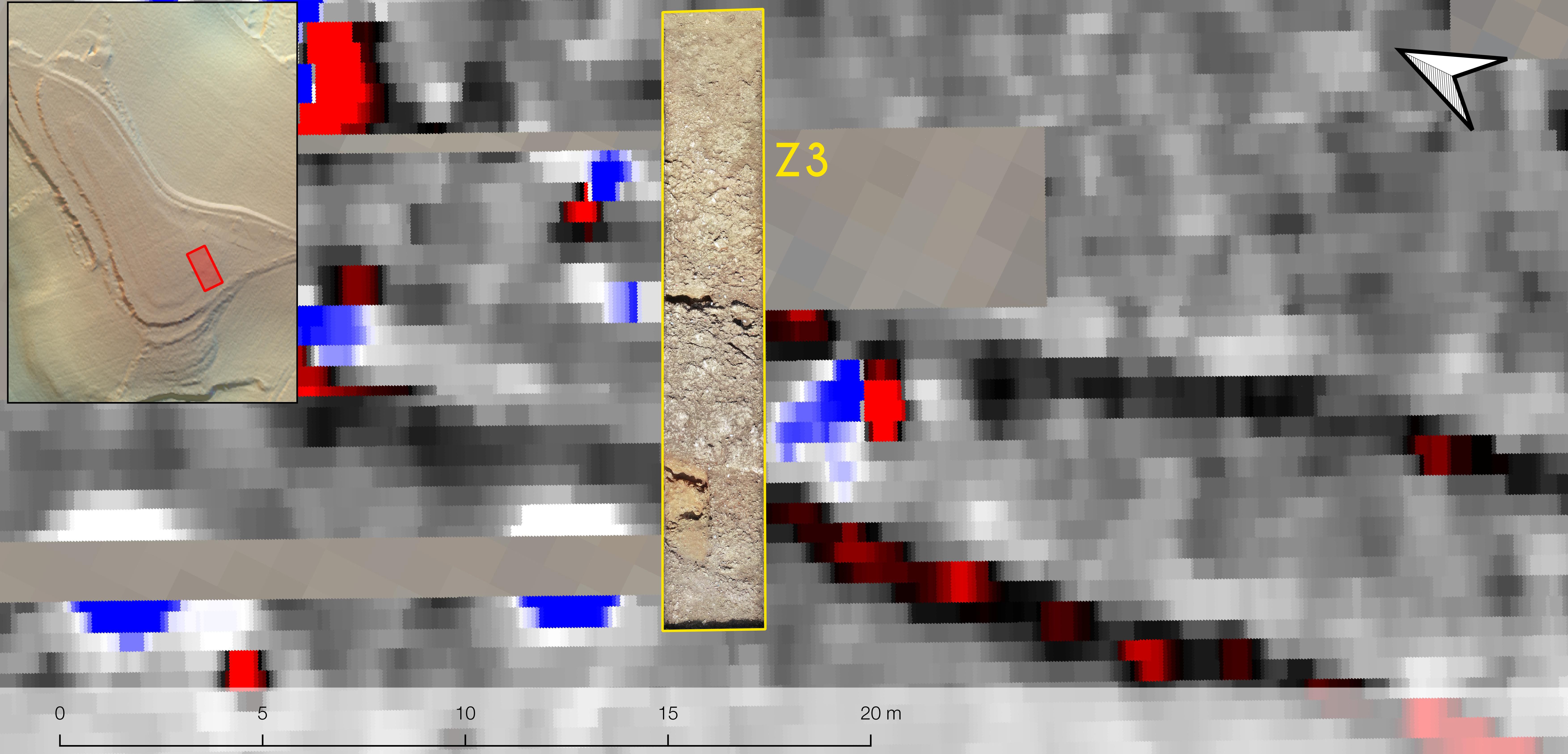
A possible road ?
Two parallel paths were revealed by the magnetic surveys facing the eastern side of the sanctuary (fig. 7). The aim of a sondage (Z3) was to understand the nature of this double linear anomaly. This claimed to complete the various measurements made by geophysics, in particular the electrical resistivity section. This suggests the presence of two parallel ditches, spaced almost 4 m apart, which bound a strong resistance anomaly features of this anomaly reminded us first an ancient road. But it was necessary to check this identification. Despite appearances, the archaeological excavation showed that these alignments are of geological origin and correspond to two faults in the limestone substratum (fig. 13).
We should emphasize that the direction of these two diaclases is strictly identical to those of the east and west sides of the sanctuary enclosure. Two hypotheses can be considered: that these geological features influenced the orientation of the sanctuary; that the workers exploited these natural substratum fractures to facilitate the digging of some of the ditches.
Possible kiln or heating structures
Two sondages (Z4 and Z5) targeted the northern part of the plateau and the potential habitat area. Here, geophysical surveys revealed a concentration of several large magnetic anomalies that could indicate the presence of heated natural materials (fig. 7). These anomalies could therefore indicate the remains of potential kilns. In order to verify this hypothesis, sondage Z4 (4 m x 4 m) was opened on one of these anomalies. This proved to be negative: the magnetic anomalies, due to natural iron concretions, were of geological origin. In addition, sondage Z5 revealed a large pit filled with material from the Second Iron Age.
These examples emphasize the need to combine the approaches (geophysics + excavation) to test our knowledge. They demonstrate that archaeological verification is essential to validate or invalidate our interpretations.

The site of Blis (Eymet, France)
General presentation of the site and history of research
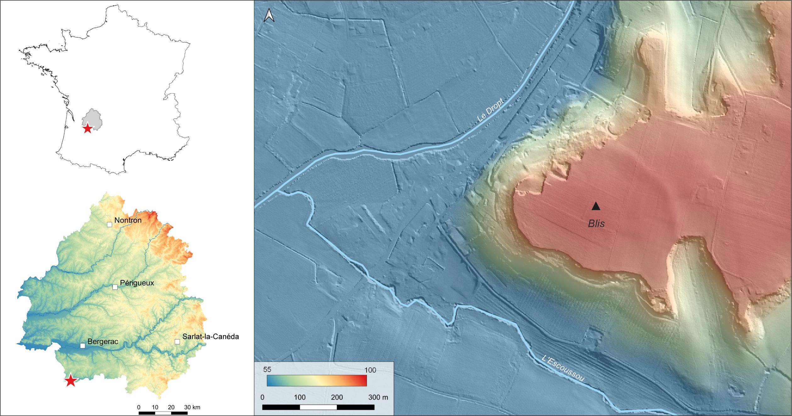
The site of Blis (Eymet, France) is located in the south of the Dordogne department (fig. 15). It is on a triangular promontory overlooking the confluence of the Dropt and Escoussou rivers. The headland is 100 m high and is surrounded by steep slopes on two of its sides. Its eastern part is bordered by a curved anomaly corresponding to a slight earthen embankment that can be seen in the landscape. This embankment and the slopes of the plateau delimit an area of about 8 hectares.
The landowner, Jacques Combaud, first mentioned the Blis site in 2017. He discovered a great quantity of ceramic and metal artefacts at the surface, including many celtic coins. From 2018, studies led by Thierry Mauduit and then Christian Chevillot (with the ADRAHP team) completed the collection by pedestrian prospections51. Specialized studies have revealed an occupation starting at the end of the Bronze Age with a progressive evolution during the Early Iron Age. Some elements already indicate a habitat context from the end of the Hallstatt period. The La Tène period (3rd – 1st century BC) is very well documented, especially by numerous celtic coins (121 pieces) dated between La Tène C and the first century BC. Finally, rubbly clay and limestone blocks were collected at the surface of the slope.
Given the nature, richness, and chronology of the inventoried material, the site of Eymet appears to be a commercial open agglomeration from the 3rd century BC. It was therefore included in the study corpus of RAPSODIE. In 2020, the site was subjected to a series of geophysical surveys. The same methodology as the one used at La Peyrouse (cf. infra) was employed to explore the Blis site: a first large-scale magnetic survey (vertical gradient) was carried out in order to map the presumed settlement features and specify its shape, extent, internal organization, and immediate surroundings52. In addition to the magnetic surveys, electrical surveys (mapping and ERT) were conducted, focusing exclusively on the embankment.
Evidence of a Celtic settlement
Artefacts collected on the Blis plateau have highlighted several chronological phases. The oldest elements date back to the end of the Bronze Age. The site was therefore already frequented during this period with a development during the early Iron Age. This first trend is represented only by a few fragmentary elements but already denotes a context of habitation. Some sherds of corded smooth ceramics, a biconical-headed pin dating from the Late Bronze Age to the early Iron Age transition, and two fibulae from the early Iron Age can be associated with this early phase.
The La Tène phase is the most well-represented, with a significant collection of objects dating from the 3rd to the 1st century BC. The majority of the corpus is composed of metallic objects. From this period, one can note:
- numerous adornments artefacts (bracelets, rings, fibulae and beads) and harness accessories (harness pendants, strap loops) made of copper alloys.
- several casting funnels made of copper-based alloys and bronze slag have been discovered, suggesting a metallurgical activity related to the production of copper alloy objects on the site.
- 121 Celtic coins whose chronological face refers to an early period (mainly the 3rd century BC). 4 silver ingots that can be attributed to this period were also discovered on the spur.
Ceramics are less prominent than metallic furniture. Some very fragmented shards of common Late La Tène ceramics, amphorae, and spindle whorls were found in regularly plowed vineyards.
The collected elements indicate that the site was part of a commercial network established in the 3rd century BC, as shown by the coin collection. The production of copper alloy objects dominated the site. The site was abandoned at the end of the 1st century BC. Only a few later anecdotal elements have been discovered on the site. No roman or medieval coins are present in the collection.
Main geophysical results
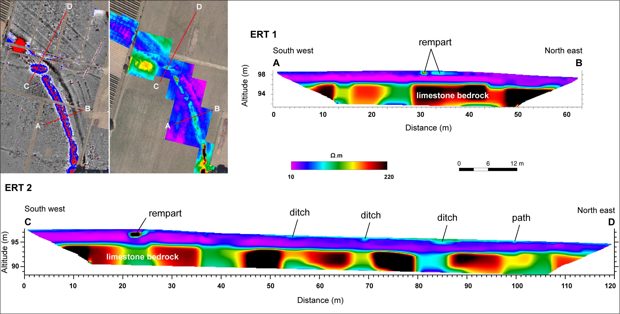
In the area surrounded by the earth embankment and the slopes, the results of the magnetic survey did not show any clear archaeological features (fig. 16, A). However, the magnetic records on the embankment show a strong dipole anomaly corresponding to the curved topographic anomaly. It is characterized by a considerable amplitude of the magnetic gradient. This anomaly could be compared to the signal of strongly heated material. This interpretation explains the concentration of burnt clay in the field, which extends along the entire length of the embankment. It suggests the presence of a burned rampart. The vines prevented us from conducting a magnetic survey in the northern part of the embankment. However, the concentration of micro fragments on the ground shows that the structure extends to this part. A power pole heavily disturbs the central part and the map is difficult to read at its location.
The magnetic signal is interrupted at two points, which probably mark two entrances. The first entrance is in the south, near the slopes, and the second in the middle of the line. An egg-shaped anomaly running east west, diverging from the rest of the line, suggests the remains of a monumental entrance (bastion gate). On the electrical resistivity map, the rampart appears as a resistive anomaly (fig. 16, B). The contrast is much more pronounced to the south, at the level of the break observed during magnetic prospecting. The electrical map exhibits the shape of an entrance with retracted wings. The reading of the map is more complex towards the north. In fact, vineyard ploughing disturbs heavily the embankment. Finally, the environment is strongly conductive.
In the outer part, investigations revealed several ditches on the earthen wall front, each 10 m apart (fig. 16). The nearest trench corresponds to a continuous magnetic anomaly. Parallel to it are three linear anomalies equidistant from each other, which are lost to the south. They are interrupted before the central entrance. New linear anomalies have been discovered in the north, but their features are not as regular as those in the south. Therefore, their continuity is not certain. They are also interrupted in front of the main entrance. Between the two groups of ditches, there is an arc-shaped ditch anomaly, which is oriented differently. Two other similar anomalies were discovered to the southeast of the map, with no clear connection to other anomalies. Finally, the linear anomaly north of the other ditches appears to correspond to an ancient road seen on the old maps.

The first ERT through the earthen wall and the outer trenches shows a resistant core preserved to a thickness of about 1.20 m (fig. 17). This core rests on a highly conductive horizontal layer. The homogeneity of this layer does not allow the identification of the wide ditch, embedded in the highly conductive signal. It is therefore impossible to estimate the dimensions of the structure. The second electrical section provided a first vertical view of the trenches to the north. They are trenches about 1 m deep, more or less wide, filled with a slightly more resistant material than the one present in the surrounding area.
The archaeological excavation in 2021
Geophysical surveys have provided a first image of a new fortification closing the spur on its eastern side. These results, in conjunction with the artefacts53, raise about the nature of the site. Indeed, the discovery of a fortification calls into question the occupation model of the site, which was first characterized as an open settlement in the 3rd century BC. Several configurations were possible: a fortified settlement throughout the occupation, an open settlement that was then fortified, or a fortified and then open settlement.
After the initial geophysical surveys, a first excavation campaign was carried out in 2021 under the direction of J. Hantrais and Q. Verriez54. This archeological exploration pursued several objectives:
- To clarify the chronology of the rampart in order to better understand the site occupation model,
- To document the ditch, the architecture and the materials used for the rampart,
- To compare the geophysical results with the archaeological data.
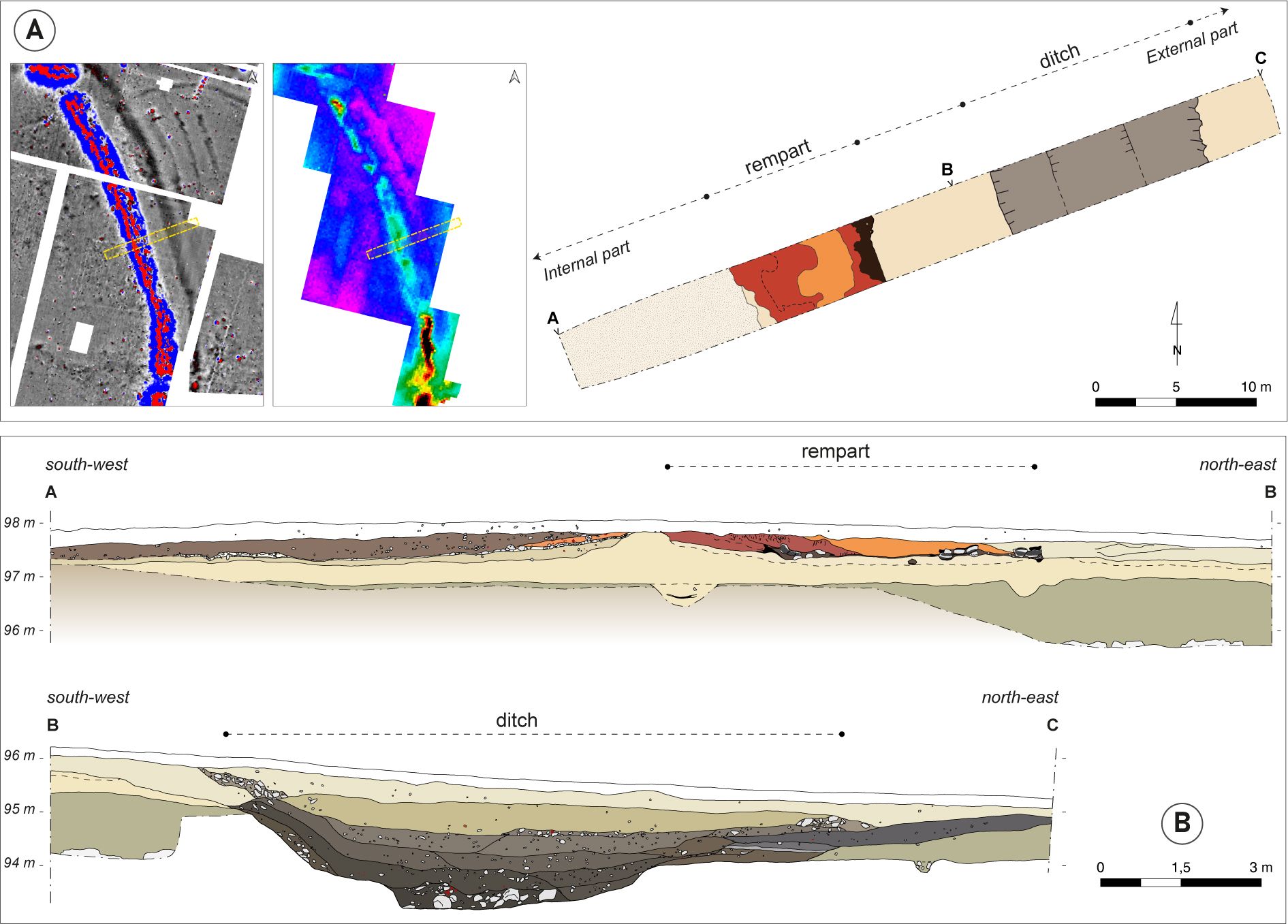
The hypothesis of a burnt rampart was quickly confirmed by the discovery of burnt clay and charred wood (fig. 18, A). The preservation allowed us to understand the original architecture and the materials used. It is a monumental construction built around a wooden structure and raw earth elements. The remains of the rampart are at the top of a sterile slope only of 1.15 m thick.
In the best-preserved areas, the excavation revealed a plane of charred longitudinal and transverse timbers, preserved horizontally over a width of 7 m55. According to the radiocarbon dating carried out on the wood, it seems to have collapsed in the First Iron Age without further precision. This horizontal timber arrangement was connected to rows of vertical pairs of posts. In fact, ten post-holes of depth of 0.20 to 0.40 m and a diameter of 0.25 m were uncovered.
These wooden elements are connected to a structure of raw dirt. The remains of it is a large clay mass that covers the charred wood. This clay layer is the source of the recorded magnetic signal. This layer, partially removed by agricultural work, is preserved to a maximum thickness of 35 cm. Traces of clay clods were found during the excavations. These observations indicate that originally one or more raw clay walls were built into the facade, which collapsed during the fire.
The main linear anomaly in the exterior was identified as a wide ditch at 8 m in front of the rampart (fig. 18, B). It opens to a width of 13 m and narrows to 4.50 m at the bottom. Its excavation reaches a maximum depth of 1.20 m (2.35 m below the surface). It completely cuts through a natural clay layer and intersects the limestone over 40 cm. It is a stair-like structure with a flat bottom. The eastern boundary has a sharply flared edge, while the wall becomes steeper towards the west.
The trench is filled with clayey material that does not contrast with the bedrock. This lack of contrast explains the absence of the ditch on the sections with electrical resistance hidden in an equally conductive medium. Below these fills is a very organic level that lies between the upper fills and thickens beyond the eastern limit of the trench. It is a spread consisting of numerous inclusions of charcoal, ceramics, fauna, slag and fragments of crucibles. It could be remains of a habitat or metallurgical workshops. This level is the origin of the magnetic anomaly, originally interpreted as one of the ditches parallel to the wider ditch.
The excavations have yielded an abundance of archaeological material in which La Tène artefacts are the most numerous. The collection came mainly from an abandoned layer on the inner side of the site and from the fillings of the ditch. There is a large quantity of ceramics, mainly from the Late Iron Age. Some shards are dated to the Late Bronze Age and the First Iron Age. Dressel 1B amphorae are very present, especially in the internal abandonment levels of the site. Contrary to the surface surveys, the excavation yielded an important batch of faunal bones, which would be domestic discards.
The metal furniture is very well represented by several iron elements (nails, tools, rings, …). The excavation of the outer ditch yielded a batch of crucibles and slag that confirms a metallurgical activity on the site.
The furniture and its chronology do not differ from that collected during the pedestrian prospections. It has all the characteristics of an agglomeration occupied since the First Iron Age. The C14 dates on the rampart seem to support this.
Conclusion and perspectives on the Blis site
The geophysical prospections provided a first plan and a first vertical view of an original fortification system consisting of a rampart and several external ditches. The richness of these results quickly led to an archaeological excavation. This confirmed the fire of the rampart, which was already suspected before the intervention. It shows an original architecture, which mixes raw earth and wood, dated to the first Iron Age. For now, this construction of raw earth has little comparison. Rare examples of the use of this material in monumental architecture are documented, especially in the west of France (Bouguenais56). On the other hand, several cases of burnt ramparts dated to the First Iron Age are known in the region and in Celtic Europe in general. A local example is the Niord rampart at St-Etienne-de-Lisse (Gironde), although in this case the architecture and the materials used are somewhat different57.
The functional and chronological data gathered during the excavation indicate the presence of a rampart as early as the First Iron Age. During this initial phase of occupation, the site may have been a fortified hill. However, there is no definitive evidence that indicates when the rampart was burned, making it difficult to determine if it was used during the Second Iron Age. Nonetheless, we are certain that the ditch is contemporaneous with the rampart based on comparisons with other examples of La Tène fortification. The ditch was filled in at the end of the Latin period, as evidenced by the majority of the material found in its fill. This suggests that the fortification was still present at the end of the Iron Age, and that the site was fortified throughout its occupation.
These findings challenge the initial identification of an open settlement based on the material found on the surface. In additional, the geophysical surveys did not reveal any additional features that would have contributed to the organization of a potential settlement, such as potery kiln or internal buildings. Therefore, there is no evidence to confirm the status of the site as an agglomeration. This example perfectly illustrates the biases that are induced by the different prospecting methods (pedestrian and geophysical).
The archaeological interest in the Blis site invites further investigation. Several questions remain unanswered. What are the type of entrance doors? Are the ditches contemporary? What is this fortification demarcated from? What is the nature of the site?
Conclusion
The first results of the RAPSODIE project illustrate the interest of integrated approaches to document settlements extending over vast areas. Here, they focus on settlements that developed from the 3rd century BC onwards in the southwest Gaul.
The approaches developed on the sites of La Peyrouse and Blis combine extensive non-intrusive methods that are complemented by invasive data from archaeological surveys or excavations.
On these two sites, the dialogue between these data has allowed us to renew our knowledge of the morphology and environment of these settlements, aspects that remained largely unknown.
The outcomes highlight the great potential of geophysical surveys for an efficient investigation of these sites. Indeed, the magnetic surveys at La Peyrouse and Blis allowed detecting many features of ancient occupations. At La Peyrouse, the most striking features are the discovery of a presumed mineral extraction area, potential artisanal production sites, a public enclosure and a religious building. At Blis, geophysical surveys revealed an unusual fortification whose characteristics suggest a burned out rampart.
The importance and complementarity of approaches combining geophysical and stratigraphical analyses must be emphasized. First of all, this allows to set up a reasoned strategy for the archaeological exploration of a site, especially if it covers several hectares. In other words, this promotes a reasoned control of time, issues and means (both material and human) implemented.
This research also illustrates that archaeological verification based on the geophysical date is essential. Thus, archaeological excavations provide chronological and functional elements that are missing from the geophysical data. Finally, they are needed to compare interpretations and understand the origin of the geophysical anomalies detected.
At La Peyrouse, the data relating to the morphology of the agglomeration has been coupled with environmental and geomorphological data. These allow a better understanding of its environment, the evolution of the environment and the settlement strategies. This aspect deserves to be developed in Blis.
It can also be seen that the methods used and the tools called upon must be adapted to the underlying research problems. While at La Peyrouse the presence of an open agglomeration with an artisanal and commercial vocation seems assured, the case of Blis raises questions. While the facies of the material collected is similar to that found in contemporary open settlements, the discovery of a rampart implies the existence of a fortified site. This example perfectly illustrates the methodological bias induced by the surveys, and confirms the interest of comparing data to document these Iron Age settlements. It also highlights the complexity of the possible configurations and life scenarios of the ‘settlements’ during the Iron Age.
Acknowledgments
The geophysical surveys were carried out within the framework of the RAPSODIE project, financed by the Nouvelle-Aquitaine Region as part of its ESR call for proposals. The archaeological excavations received financial support from the French Ministry of Culture (DRAC), the Dordogne Departmental Council (CD24), HADES Archéologie, the University of Bordeaux and the University of Bordeaux Montaigne. This study also received financial support from the French government in the framework of the University of Bordeaux’s IdEx “Investments for the Future” program / GPR Human Past.
We would like to thank all of the volunteers and the many colleagues who work in the framework of the research carried out on the sites of La Peyrouse and Eymet.
Finally, we would like to express our gratitude to the Gay and Combaud families who own the sites.
Additional content
Vue aérienne du sanctuaire de La Peyrouse (2022 ; prise vidéo par drone C. Coutelier).
References
- Ard, V., Mathé, V., Lévêque, F. and Camus, A. (2015): “A comprehensive magnetic survey of a Neolithic causewayed enclosure in West-Central France for the interpretation of archaeological features”, Archaeol. Prospect., 22, 21‑32, [online] https://onlinelibrary.wiley.com/doi/full/10.1002/arp.1495 [consulted 19/03/2023].
- Aspinall, A., Gaffney, C. and Schmidt, A. (2008): Magnetometry for Archaeologists, AltaMira.
- Barral, P., Bossuet, G., Daubigney, A., Camerlynck, C., Dabas, M. and Thivet, M. (2008): “Un exemple d’approche intégrée d’un établissement de la fin de l’âge du Fer : Authumes ‘Le Tertre’ (Saône-et-Loire)”, in: Blanchard & Izac-Imbert, ed. 2008, 33‑43, [online] https://www.researchgate.net/publication/281048675 [consulted 19/03/2023].
- Barral, P., Bossuet, G. Joly, M., Dabas, M., Camerlynck, C., Aubry, L. Daubigney, A., Thivet, M. and Alix, S. (2009): “Applied geophysics in archaeological prospecting at sites of Authumes (Saône-et-Loire) and Mirebeau (Côte-d’Or) (Bourgogne, Eastern France)”, ArchéoSciences, Suppl. 33, 21‑25, [online] https://doi.org/10.4000/archeosciences.1204 [consulted 19/03/2023].
- Bertrand, I., Duval, A., Gomez de Soto, J. and Maguer P., dir. (2009): Les Gaulois entre Loire et Dordogne, Actes du 31ecolloque international de l’AFEAF, Chauvigny.
- Beyrie, A. and Fabre, J.-M. (2021): “Mines et métallurgie du fer sur le site de La Peyrouse. Premières prospections sidérurgiques et potentiels d’études”, in: Hiriart & Chevillot 2021, 75‑134.
- Blanchard, J.-L. and Izac-Imbert, L., ed. (2008): L’exploitation agricole dans son environnement à la fin de l’âge du Fer. Nouvelles approches méthodologiques, Toulouse.
- Brunaux, J.-L. and Malagoli, C. (2003): “La France du Nord (Champagne-Ardenne, Ile-de-France, Pas-de-Calais, Picardie)”, Cultes Sanctuaires en France à L’âge du Fer, 60, 9‑73, [online] https://doi.org/10.3406/galia.2006.3295 [consulted 19/03/2023].
- Buchsenschutz, O., Colin, A., Krausz, S., Levéry, M., Soyer, C. and Villard, A. (1993): Le village celtique des Arènes à Levroux: description des structures, Levroux 2, Tours, [en ligne] https://www.persee.fr/doc/sracf_1159-7151_1993_arc_8_2 [consulted 19/03/2023].
- Chevillot, C. (2017a): “Enquête sur la voie gauloise de long parcours de Ouesona à Aginnum. 1. Le segment de Vergt à La Peyrouse”, Doc. D’Archéologie D’Histoire Périgourdines, 195‑216.
- Chevillot, C. (2017b): “La Peyrouse, un nouveau bourg Pétrocore sur la voie gauloise Ouesona/Aginnum (Saint-Félix-de-Villadeix, Dordogne)”, Doc. D’Archéologie D’Histoire Périgourdines, 31, 11‑68.
- Chevillot, C. (2021): “Enquête sur la voie gauloise de long parcours de Ouesona à Aginnum, 2. Le segment de La Peyrouse à Mouleydier”, Doc. D’Archéologie D’Histoire Périgourdines, 35.
- Chevillot, C. and Combaud, J. (2019): “Catalogue du mobilier du site gaulois de ‘Blis/Roc de Salomon’. Commune d’Eymet (Dordogne)”, Doc. Archéologie Hist. Périgourdines, 34, 53‑84.
- Chevillot C. and Hiriart, E. dir. (2019): Les opérations archéologiques menées à La Peyrouse (Saint-Félix-de-Villadeix, Dordogne) en 2019, Rapport final d’opération, SRA Nouvelle-Aquitaine.
- Chevillot, C. and Hiriart, E. (2020): “Les opérations archéologiques menées à La Peyrouse, Saint-Félix-de-Villadeix (Dordogne) en 2019”, Doc. Archéologie Hist. Périgourdines, 34, 85‑116.
- Colin, S., Glais, A., Leroyer, A. and Steinmann, R. (2021): “Approche paléoenvironnementale du site de La Peyrouse : la vallée du Caudeau en contrebas”, in: Hiriart & Chevillot 2021, 136‑161.
- Coutures, P. (2004): “Saint-Étienne-de-Lisse – Niord”, Bilan Scientifique Régional Aquitaine, 95‑96.
- Delrieu, F., Féliu, C., Gruat, P., Kurzaj, M.-C. and Nectoux, É. (2021): Les espaces fortifiés à l’âge du Fer en Europe, Actes du 43e colloque international de l’AFEAF, Puy-en-Velay.
- Denti, M. and Villette, M. (2019): Archéologie des espaces artisanaux : fouiller et comprendre les gestes des potiers, Actes du Colloque international de Rennes, Montpellier.
- Fernández-Götz, M., Wendling, H., K. Winge, ed. (2014): Paths to Complexity. Centralisation and Urbanisation in Iron Age Europe, Oxford-Philadelphia.
- Fichtl, S. (2013): “Les agglomérations gauloises de la fin de l’âge du Fer en Europe celtique (IIIe-Ier s. av. J.-C.)”, in: Garcia 2013, 19‑44, [online] https://www.academia.edu/3676333/ [consulted 19/03/2023].
- Fichtl, S. and Barral, P. (2019): “Conclusions. Quelques réflexions sur les agglomérations celtiques de La Tène moyenne et finale”, in: Fichtl et al. 2019, 439‑450.
- Fichtl, S., Barral, P., Pierrevelcin, G. and Schönfelder, M. ed. (2019): Les agglomérations ouvertes de l’Europe celtique : IIIe-Iers. av. J.-C., Strasbourg.
- Fichtl, S. and Trebsche, P. (2018): “L’agglomération celtique de La Tène moyenne de Haselbach (Basse-Autriche) : premiers résultats des campagnes de 2015 à 2017”, Bull. Assoc. Fr. Pour Létude Lâge Fer, 36, 25‑28, [online] https://hal.science/hal-02522856v1 [consulted 19/03/2023].
- Garcia, D. dir. (2013): L’habitat en Europe celtique et en Méditerranée préclassique – Domaines urbains, Paris.
- Gruel, K., Dabas, M. and Bernollin, V. (2009): “Contribution of large scale geophysical survey to analysis of the evolution of the western boundary of the city of Allonnes (Sarthes, France): Integration of Google images, the Napoleonic cadastre and large magnetic surveys”, ArchéoSciences, Suppl. 33, 179‑181.
- Hantrais, J., Mathé, V., Corfmat, P., Chapoulie, R. and Hiriart, E. (2021): “Regards croisés sur le sanctuaire laténien de La Peyrouse (Saint-Félix-Villadeix, Dordogne)”, ArchéoSciences, 45, 2, 43‑54, [online] https://doi.org/10.4000/archeosciences.10527 [consulted 19/03/2023].
- Hantrais, J., Verriez, Q., Chevillot, C., Mauduit, T. and Hiriart, E. (2022): “Un système de fortification original en terre et bois découvert sur l’agglomération celtique de Blis à Eymet (Dordogne) : résultats de la fouille 2021”, Bull. AFEAF.
- Hantrais, J., Verriez, Q., Mauduit, T., Chevillot, C., Mathé, V. and Hiriart, E. (2022): “L’éperon barré de Blis (Eymet)”, Doc. Archéologie Hist. Périgourdines, 36.
- Hiriart, E. (2019a): “Les agglomérations artisanales et l’apparition de l’usage monétaire dans le monde celtique (IIIe s. et début du IIe s. av. J.-C.)”, in: Fichtl et al. 2019, 419-436, [online] https://hal.science/hal-03155221 [consulted 19/03/2023].
- Hiriart, E. (2019b): “Les débuts de la monétarisation des échanges en Europe celtique (IIIe siècle-début du IIe siècle avant notre ère)”, Archéopages : archéologie & société, HS 5, 56-63, [online] https://doi.org/10.4000/archeopages.8959 [consulted 19/03/2023].
- Hiriart, E. (2022): Aux premiers temps de la monnaie en Occident. Pratiques économiques et monétaires entre l’Èbre et la Charente, Bordeaux.
- Hiriart, E., Smělý, T., Genechesi, J., Gruel, K., Nieto-Pelletier, S. and Wigg-Wolf, D. (2020): “Coinages and economic practices between the 3rd century and the beginning of the 2nd century BC”, in: Kysela & Pierrevelcin 2020, 181-212, [online] https://hal-u-bordeaux-montaigne.archives-ouvertes.fr/hal-02072189/ [consulted 19/03/2023].
- Hiriart, E. and Chevillot, C. dir. (2021): Le Projet Collectif de Recherche La Peyrouse (Saint-Félix-de-Villadeix, Dordogne), Rapport intermédiaire 2021 (1ère année), SRA Nouvelle-Aquitaine.
- Hiriart, E., Chevillot, C., Hantrais, J., Corbasson, C., Sarrazin, J.-C. and Mathé V. (2021): “Le sanctuaire celtique de ‘ La Peyrouse ’ à Saint-Félix-de-Villadeix (Dordogne) : résultats de la campagne 2020”, Bull. Assoc. Fr. Pour L’étude L’âge Fer, 39, 41‑44, [online] https://hal.science/hal-03282919 [consulted 19/03/2023].
- Hiriart, E., Chevillot, C., Hantrais, J., Bertaud, A., Brochot, M., Corbasson, C., Demierre, M., Fabiani, M., Loirat, D., Mounier, A., Olmer, F., Rolland, J., Rousseau, É., Sarrazin-Robert–Dejeans, J.-C., Valette, R. and Mathé, V. (2022): “Un premier sanctuaire celtique en Aquitaine. Résultats des fouilles menées en 2020 sur l’agglomération ouverte de La Peyrouse (Saint-Félix-de-Villadeix, Dordogne)”, Aquitania, 38, 7-51.
- Holzer, V. (2014): “Roseldorf – An Enclosed Central settlement of the Early and Middle La Tène Period in Lower Austria (Roseldorf Němčice Centre”, in: Fernández-Götz & Winger 2014, 122‑131, [online]https://www.academia.edu/16864469/V_Holzer_2014_Roseldorf_An_Enclosed_Central_settlement [consulted 19/03/2023].
- Křivánek, R. (2016): “Magnetometric survey”, in: Venclová 2016, 16‑22.
- Kysela, J. and Pierrevelcin, G. dir. (2020): Unité et diversité du monde celtique, Actes du 42e Colloque international de l’AFEAF, Prague.
- Maniquet, C. (2009): “Le sanctuaire gaulois de Tintignac (Corrèze)”, in: Bertrand et al. dir 2009, 121‑148, [online] https://www.academia.edu/19850104/Le_sanctuaire_gaulois_de_Tintignac_Corr%C3%A8ze_ [consulted 19/03/2023].
- Mathé, V., Camus, A., Mauné, S. and Bourgeon, O. (2019): “Apports des prospections magnétiques et électriques à la reconnaissance des ateliers de potiers antiques. L’exemple de l’Estagnola à Aspiran (Hérault)”, in: Denti & Vilette 2019, 359‑362.
- Mathé, V., Hantrais J. and Hiriart, E. (2020): “Prospections géophysiques dans le vallon situé entre Langlade et La Peyrouse”, in: Hiriart & Chevillot 2020, 129‑153.
- Mathé, V., Martinaud, M., Garmy, P. and Barraud, D. (2011): “L’agglomération antique de Brion à Saint-Germain-d’Esteuil (Gironde – France): Organisation de l’espace, structures et formes de l’urbanisme”, Aquitania, 27, 215‑242, [online] https://doi.org/10.3406/aquit.2011.953 [consulted 19/03/2023].
- Mathé, V., Pouponnot, G., Lévêque, F. and Camus, A. (2015): “Diagnostic archéologique et prospection géophysique : regards croisés sur une vaste occupation gauloise du second âge du Fer (Aiffres, Deux-Sèvres)”, in: 20e Colloq. Int. Groupe Méthodes Pluridiscip. Contrib. à L’Archéologie 2015, Besançon.
- Paillou, P. (2017): “Mapping Palaeohydrography in Deserts: Contribution from Space-Borne Imaging Radar”, Water, 9, 3, 194, [online] https://www.researchgate.net/publication/ [consulted 19/03/2023].
- Paillou, P., Lopez, S., Ruffié, G. and Delalée, F. (2021): “DRONESCAT : Système actif hyper-fréquences porté par drone”, Journ. Drones Capteurs Embarqués.
- Rémy, J. (2021): “De terre et de bois: un rempart du Hallstatt moyen/final à Bouguenais (Loire-Atlantique)”, in: Delrieux et al. 2021, 119‑122.
- Rolland, J. (2021): Le verre de l’Europe celtique: approches archéometriques, technologiques et sociales d’un artisanat du prestige au second âge du Fer, Leiden.
- Salač, V. (2012): “Les oppida et les processus d’urbanisation en Europe centrale”, in: Sievers & Schönfelder, ed. 2012, 319‑345, [online] https://www.academia.edu/10698676/ [consulted 19/03/2023].
- Steinmann, R. and S. Colin (2020): “Rapport de l’étude géoarchéologique du vallon de La Ruchelle”, in: Hiriart & Chevillot 2020, 109‑127.
- Venclová, N. , dir. (2016): Němčice and Staré Hradisko Iron Age glass and glass-working in Central Europe, Prague, [online] https://www.academia.edu/31782780/Venclov%C3%A1_N [consulted 19/03/2023].
- Verdet, C. and C. Sirieix (2019): “Mesures géophysiques sur le site de La Peyrouse (24) : secteur de la grotte”, in: Chevillot & Hiriart 2019, 163‑174.
Notes
- Salač 2012; Fichtl 2013.
- RAPSODIE project (Reconnaissance des Agglomérations Protohistoriques du Sud-Ouest: Dynamiques, Imagerie, Environnement), led by E. Hiriart in partnership with V. Mathé (LIENSs, University of La Rochelle), supported by the ESR 2019 call for projects, Conseil régional de Nouvelle-Aquitaine. (and co-funded by Université Bordeaux-Montaigne and Université de Bordeaux). J. Hantrais benefits from a PhD grant in the framework of the project.
- The open agglomeration mainly multiplied during the 2nd and 1st century BC (Fichtl & Barral 2019).
- Rolland 2021.
- The characterisation of these settlements is one of the key issues that now drives several researchers in the protohistorical community. Organised at Bibracte in 2015, the international round table “Celtic settlements of the 3rd-1st century BC” brought together numerous researchers around these themes and made it possible to establish the basis for a common reflection (Fichtl et al., ed. 2019). The RAPSODIE project is part of this momentum and focuses more precisely on the “first wave” of open agglomerations that developed from the 3rd century BC onwards.
- Hiriart 2019a ; Hiriart 2019b; Hiriart et al. 2020.
- Buchsenschutz et al. 1993.
- Barral et al. 2008; Barral et al. 2009.
- Porteur K. Gruel (AOrOc – UMR 8546 ENS-CNRS).
- Gruel et al. 2009.
- Holzer 2014.
- Fichtl & Trebsche 2018.
- Křivánek 2016.
- The chronology is determined by the artifacts (coins, metal or glass ornaments) collected during excavations or prospecting.
- Chevillot 2017a; Chevillot 2021.
- Programme led by E. Hiriart, financed by the Ministry of Culture and the Conseil Départemental de la Dordogne.
- Chevillot 2017b; Chevillot & Hiriart 2020.
- The Julio-Claudian period is the best represented.
- Olmer 2019.
- Hiriart 2022.
- Hiriart et al. 2022.
- Rolland 2019.
- Lack of fortification, occupation of several dozen hectares and structured organisation of the habitat.
- Several hundred reduction and forge slags have been found during excavations and archaeological surveys.
- Beyrie & Fabre 2021.
- Beyrie & Fabre 2021.
- These discoveries were made by the owner before 2014 and the start of archaeological investigations. Their precise location in the interior of the cave remains unknown. In the state, we cannot affirm if these vestiges were in primary position or if they were there because of colluvium.
- Verdet & Sirieix 2019. Another electrical profile, which is consistent with these observations, was produced by V. Mathé (Mathé et al. 2020).
- Steinmann & Colin 2020, 121-122.
- The valley is now dry in its upstream part.
- Chevillot 2017b; Hiriart & Chevillot 2020.
- Steinmann & Colin 2020.
- An archaeological diagnostic carried out in May 2022 clarified these observations. A superposition of soil levels was discovered between -3 m and -1.5 m below the current ground, covered by 1.5 m of colluvium.
- The aim is to see if there is a real issue in terms of remains or structures in place or if, on the contrary, the levels observed at the bottom of the valley are reworked layers due to colluvium.
- Colin et al. 2021.
- Tixier & Leroyer 2003; Leroyer & Allenet 2008.
- Colin et al. 2021, 156.
- Aspinall et al. 2008.
- Ard et al. 2015.
- Mathé et al. 2011.
- Mathé et al. 2019.
- Hiriart et al. 2022.
- Mathé et al. 2015.
- Chevillot & Hiriart 2020.
- Hantrais et al. 2021.
- Brunaux & Malagoli 2003; Maniquet 2009.
- A microwave pulse, of frequency ranging from MHz to GHz, is emitted into the soil and is reflected by changes in geometry and electrical properties. The frequency controls the penetration depth as well as the size of scatterers to be detected: higher frequencies allow a better resolution while lower frequencies allow to probe deeper. Dry and homogeneous soils are in general best suited for such techniques and many results were obtained over desert areas (Paillou 2017).
- Compact and light sensors are now being tested onboard drones (Paillou et al. 2021).
- Considering a mean dielectric constant around 9 for the soil leads to a penetration depth of 1-2 meters for the used frequency (two-way travel time of 50 ns), with a resolution depth of the order of 5 cm.
- Hiriart & Chevillot 2020; Hiriart et al. 2021; Hiriart et al. 2022.
- Mauduit 2018; Chevillot & Combaud 2019.
- Hantrais et al. 2022.
- Chevillot & Combaud 2019.
- Hantrais et al. 2022; Hantrais et al. 2022.
- Hantrais et al. 2022.
- Rémy 2020.
- Coutures 2004.