


Introduction
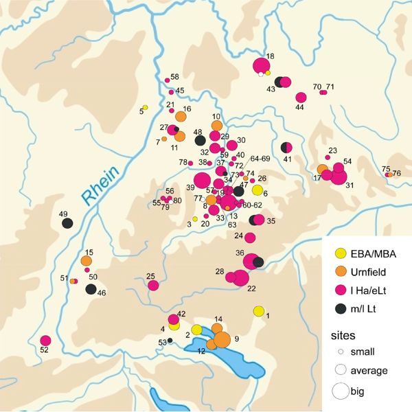
For many years archaeologists have focused on central places, also called ‘princely sites’, when dealing with the Early Iron Age. This interest was triggered by rich graves. More recently, a research project supported by the DFG has looked again at these central places. Breisach, the Heuneburg, the Ipf, Hohenasperg, Bad Dürkheim and the Glauberg were all regarded as central places in southwest Germany and nearby (Fig. 1, Kimmig 1969). The main aim now is not to find rich treasures but to gain information about Iron Age society, political structures, economics and culture. For such questions, biological remains – not only human and animal bones, but also plant macrofossils and pollens – are of particular interest. For evidence about population density and land-use intensity perhaps off-site pollen profiles are the best proxy. The situation in central places can only be understood by comparison with rural sites. Rescue excavations at many Iron Age rural sites during the last decades have provided the opportunity to sample plant remains.

Some of the central sites themselves prove less suitable for archaeobotanical studies because of poor preservation as well as taphonomic and stratigraphic problems.
Material and methods
The on-site plant macrofossil data were processed using the ARBODAT data base programme (Kreuz & Schäfer 2002). Material from about 80 sites dated between the Early Bronze Age and the late La Tène were evaluated (Fischer et al. 2010). The number of features, samples and plant remains at the sites differs considerably. The sites are not evenly distributed across the area (Fig. 2). Many are agglomerated in the middle Neckar region and nearby. Smaller agglomerations are to be found in Kraichgau, Hohenlohe/Taubergebiet, around the Ipf and Heuneburg, in southern Hochrhein and – mostly from the Bronze Age – by the Bodensee (Lake Constance).
The pollen data, both on-site and off-site, were recorded using the TAXUS programme and evaluated using Tilia (Grimm, E., https://www.ncdc.noaa.gov/paleo/tiliafaq.html, 30.12.2016). With on-site material, several hundred pollen grains were analysed in each sample. The off-site lake profiles were sampled continuously in 1 cm or 0.5 cm steps. The analysis of each sample was continued until an arboreal pollen sum of 1000 was achieved. The time-linear evaluation of the profiles is based on Bayesian time models with an input of at least 20 radiocarbon dates in each profile (BronkRamsey 2009).
Results
Crop diversity
Compared with the Early Bronze Age, cereal diversity in general expanded with the introduction of millets (Fig. 3). A group of six cereals was available and cultivated: Hordeum, Triticum spelta, Triticum dicoccon, Triticum monococcum, Triticum aestivum/durum, Panicum miliaceum and Setaria italica. A possible role of Triticum ‘New type’ is unclear. Traces of Avena and Secale cereale are not regarded as evidence of their cultivation (Behre 1992). Changes between LBA and late LT are inconspicuous. Differentiating between rural and central sites for the late Hallstatt and early La Tène period reveals stark contrasts (Fig. 3): whereas the rural sites are very similar to LBA and LT, Hordeum prevails in the central sites. Triticum spelta is as abundant as in the other periods, but all other cereals are very rare.
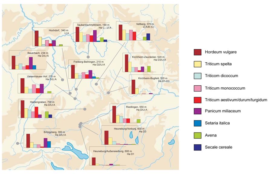
This picture is summarized in figure 4, with a focus on Iron Age sites with well represented plant macrofossils. Of these sites Heuneburg/Außensiedlung, Heuneburg/Vorburg and Kirchheim-Bugfeld were regarded as central sites; Kirchheim-Zaunäcker and Hochdorf as in-between; and the others as rural. In terms of evenness, the best statistical expression of crop diversity, the central sites have the lowest values, the rural sites the highest, and Kirchheim-Zaunäcker and Hochdorf lie somewhere in between. Similar considerations hold for other crops. For example, pulses were common during the Iron Age and especially in LBA, but during the late Hallstatt and early La Tène they were much more common in rural sites than in central sites.

Weeds, soil and crop production
Apart from the crops, crop weeds are of particular interest because they reflect the ecological and economic conditions of agriculture better than the crops themselves (Willerding 1986). As annuals, the crops need an optimal start (achieved by tillage and sowing), protection from stronger competition to get enough light, space and water (achieved by tillage and weeding) and sufficient mineral supply. Demand for nitrogen is high and is the limiting factor for plant production in many soils.
Nitrogen comes from the air and must be fixed by microorganisms. Some of these live in the soil, others in the plant roots, especially pulses. Nitrogen is stored in the organic matter (humus) of the topsoil. To make it available for plants, this organic matter must be mineralized, which is also done by soil microorganisms. This microbial process is triggered by air and warmth but hampered by excessively wet or dry soil, by the cold, or lack of oxygen. In addition to nitrogen, phosphorus and potassium are dissolved in water and therefore available for plants. Unfortunately, dissolved nutrients disappear with runoff water from the soil, which is always a major problem for farmers. Therefore, no long-term storage of plant-available nutrients in the soil is possible, at least not in wet, temperate climates. The mobile nutrients must be freshly provided each season by mineralizing the soil’s organic matter, and this organic matter must be replenished by manuring or leaving the land fallow. During fallow phases under permanent vegetation cover, organic matter is accumulated in the topsoil replenishing the stock of non-plant-available nutrients.
From LBA at the latest, farmers managed to keep the soil fertile through extensive ard cultivation with a highly sophisticated system of tillage, fallow and crop rotation including pulses. From using fallow land as pasture for domestic livestock and thereby accelerating the metabolic rate of organic matter it was a further step to collect, concentrate and compost animal dung and apply it to the field. So extensive outfield areas were used for collecting nutrients and transferring them to the field in what Menke (1995) termed a nutrient redistribution system. But systematic manuring by application of organic matter from elsewhere was most probably not practised before the late La Tène or Roman period (Tserendorj et al. 2021).
The N-indicator values as evaluated by Ellenberg et al. (1992) and displayed as weighted medium values for sites (Fig. 5) show no severe shortage of N supplies for LBA and Iron Age agriculture, in contrast to the early medieval period, a result in close agreement with N-isotope evidence (Styring et al. 2017). Clearly Iron Age agriculture was efficient.

Other on-site evidence of the Iron Age landscape
Iron Age central sites are famous for their burial mounds which – among other treasures – yielded rich bronze vessels. Most of them were excavated in times when art-history considerations prevailed in archaeology, and the question of the vessels’ original contents was perhaps never asked, or in any case never answered. This situation had fortunately changed by the 1970s when the burial mound of Hochdorf was excavated and the late Udelgard Körber-Grohne did great work analysing the biological remains of this site (Körber-Grohne 1985; Körber-Grohne & Vorwohl 1985). She showed that the huge cauldron was originally filled with about 300–400 l of a freshly prepared mead, containing between 73 and 292 kg of honey. The contents of other Iron Age bronze vessels have been analysed: the spout as well as the tube pitcher of the Glauberg, the cauldrons of Hohmichele and Speckhau tumulus 17, and a ladle from a woman’s grave at Niedererlbach/Bavaria (Rösch 1999, 2002, 2005, 2014). Depending on the pollen sum, pollen diversity is very high at all sites, indicating honey from wild bees by foraging – wild bees that had collected their pollen in a rather open cultural landscape exhibiting wide ecological and floristic diversity. It comes as no great surprise that, among the most common pollen types, bee-pollinated taxa prevail (Figs 7, 8, 9). Many taxa indicate dry, unfertilized grassland or forest edges. Looking at the modern distribution of these taxa, the regular and common occurrence of Jasione montana is striking. Jasione montana is nowadays a rare and endangered plant, with scattered occurrences in dry grassland on sandy, more or less acidic soils (Sebald et al. 1990-1998, Haeupler & Schönfelder 1988). During the Iron Age it was evidently rather common.

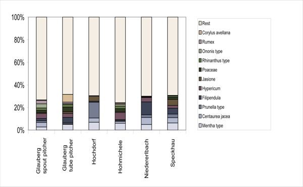


According to an ecological classification of pollen types (Fig. 10), bees used different parts of the cultural landscape as a pasture to produce honey. They flew and collected in shrubland and woodland, especially in spring when nothing flowered in grassland and fields, but also in wet meadows, dry pastures, cultivated and fallow fields, and even in settlements.

Apart from indications about former landscapes, the pollen content of these vessels yields other information. A single bee colony produces about 10-15 kg of honey per year. This would have been enough to fill the Glauberg pitchers and the Niedererlbach ladle, but not huge cauldrons. Clearly then these contained a mixture of different honeys. At the Glauberg, the pollen diversity points to a mixture containing honey produced quite some distance away (Rösch 2002). The Glauberg pitchers differ considerably in their contents. The spout pitcher, like all the cauldrons, contained a freshly prepared, unfiltered mead. Judging from its low pollen concentration, the tube pitcher contained mead that had already fermented in another vessel and was afterwards transferred to the tube pitcher.
Bee-keepers or honey foragers normally remove honey from the combs by heating/melting, pressing or gravimetry, and nowadays with a honey centrifuge. This separation is never perfect and honey invariably contains traces of bees-wax. The bees-wax content of the Iron Age vessels is so high, even keeping in mind that it has increased along with the pollen content by the disappearance of water and sugar, that it cannot be explained by insufficiently thorough separation of combs and honey, but instead by no separation at all. This makes sense, because the honey would be dissolved in water, and when the mead was ready, the separation could be done by decanting it from the fermentation vessel into another vessel. But this step was not done in the case of the burial vessels, except for the Glauberg tube pitcher.
Environmental differences of the central sites
An important question seldom asked in archaeology is why people settled where they did and not elsewhere, and why an agglomeration developed in one place and not another. Has the vicinity of these central sites some special environmental quality making it different from other places so that people chose this place and not another? Some archaeologists emphasize circulation, for example, but many if not all roads led to Rome, and the Alps could be crossed by many passes, and many streams and rivers flowed, and so on.
Why is the Heuneburg in a region which is today far from central, and why was it not founded for example where Ulm, which is the capital of this region today, was founded in the early medieval period? We have no ready answers, but we can assume that a complex pattern of different qualities, the capacity for high agrarian production, easy access to natural resources and so on prompted the choice of place. Focusing on agrarian production, we can stress marked differences among the different central sites of the Iron Age in Germany. Placing circles of 5 km radius around each central site and looking at the soils and their fertility, the potential maximum food production differs considerably (Fig. 11). Hohenasperg, the Glauberg, Bad Dürkheim and Breisach lie in or very close to loess regions with very fertile soils (Fischer et al. 2010). The number of people that could be nourished at these sites was double that at the Heuneburg and Ipf where the soils were poorer and much of the land was too steep or wet for ploughing.

On-site and off-site pollen data at the Heuneburg
The Heuneburg is the central site that provides the best environmental data set. Pollen spectra from different features throw light on the site’s vegetation. The degree of – anthropogenic – deforestation can be inferred from the relation between arboreal pollen (trees and shrubs) and non-arboreal pollen (herbs and grasses) using a correlation curve (Rösch 1994). In this relation, arboreal percentages below 30% point to a total lack of woodland; above 95% to closed woodland covering the entire land surface.
In the uppermost layers of the cauldron’s filling, in Speckhau tumulus 17, a concentration of moss was detected, perhaps from caulking between the cauldron and a non-preserved lid. It was identified as Thuidium delicatulum mixed with some Thuidium tamariscinum and traces of Leucodon sciuroides. This material was most probably collected from extensive pastures near the Speckhau tumuli. Arboreal pollen accounts for about 40% of the composition, which points to an openness of more than 80% and a woodland coverage of less than 20%; perhaps a pasture with isolated trees and shrubs (Fig. 12). In the outer ditch of the Heuneburg, the arboreal percentage is even lower (Fig. 12), indicating woodland cover of not much more than 10%. In two profiles from the inner ditch, the arboreal pollen count is even lower, suggesting woodland cover below 10%, perhaps approaching zero. We can conclude that, in contrast to the present-day situation, the vicinity of the Heuneburg was largely deforested.
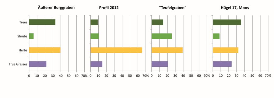
What kind of trees and shrubs were to be found, albeit in small quantities? In the ditches of the Heuneburg, Salix is the most common, most probably growing in the ditches themselves as an obstacle to crossing (Fig. 13). Rather common are the pioneers and shrubs Betula, Corylus, Alnus, Sambucus nigra/racemosa, among trees Quercus and Pinus, both with high pollen production and dispersion.
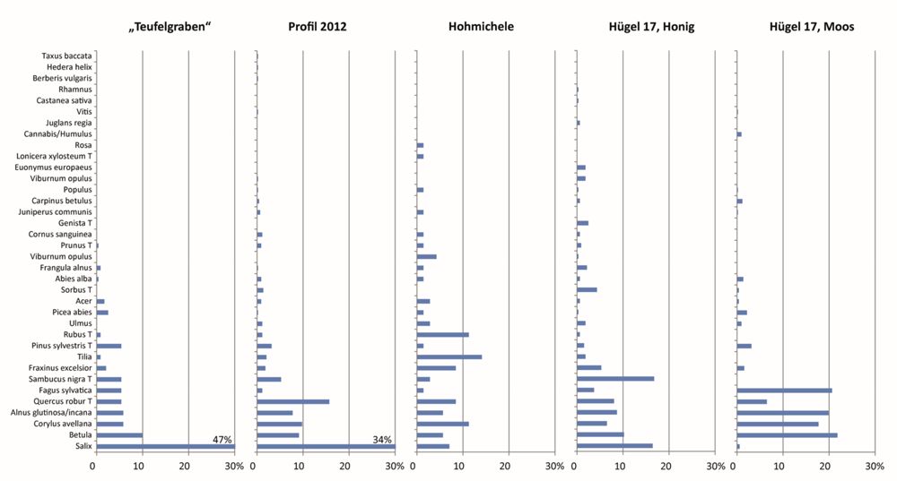
The honey residue of the Hohmichele cauldron contains a lot of Tilia, Rubus and Salix (Fig. 13). This pollen was used and collected by bees, together with Viburnum lantana and some less frequent types. It is difficult to say whether the wind-borne Corylus, Quercus, Fraxinus, Alnus and Betula pollens were also collected because in spring bees’ food is still rare, or whether they came by chance into the cauldron. In general, arboreal pollen is less common in such honey residues than pollen from bee-pollinated grasses. In the Speckhau tumulus 17 cauldron, Sambucus nigra/racemosa and Salix are the most common arboreal pollens (Fig. 13). Among the moderately common types only Maloideae are bee-pollinated, the others wind-pollinated.
The arboreal pollen composition is totally different. The pollen content of the moss from the Speckhau tumulus 17 cauldron differs considerably from all other on-site pollen spectra (Fig. 13). Here arboreal pollen clearly prevailed and it would also have dominated in lake sediments or peat of this period with Betula, Fagus, Alnus, Corylus and Quercus.
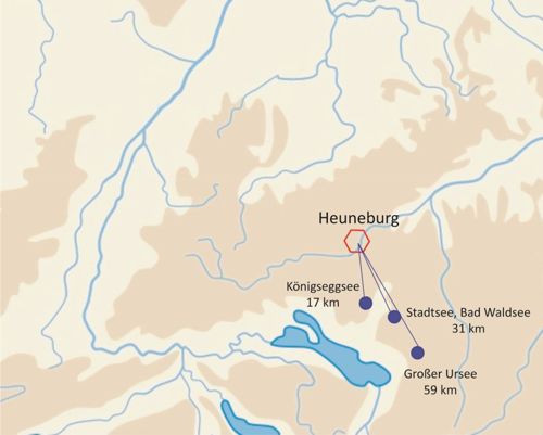
At the Heuneburg no off-site pollen analysis is possible because suitable sites are lacking (Smettan 2010). Sites can be found in the region of Oberschwaben which was covered by ice during the Weichselian, at a distance of at least 12 km to the south and south-east. In the Federsee basin, 15 km to the east, a lot of pollen analytical work has been done (Liese-Kleiber 1990, 1993). Large but shallow lakes and mires often cause stratigraphic and taphonomic problems. To avoid these, we focused on central cores from small, deep lakes. They are some distance from the Heuneburg (Fig. 14). For the moment, profiles from three lakes are available: Königseggsee, 17 km away, Stadtsee of Bad Waldsee, 31 km away, and Großer Ursee, 59 km away (Fischer et al. 2010, Rösch et al. 2020). Further profiles such as Zellsee/Bad Schussenried, Schreckensee, Obersee/Kisslegg, Ruschweiler See, Olzreuther See and Bodensee-Gnadensee are in preparation. They will form two transects from the Heuneburg to the south-east and to the south. They will enable us to check the influence of the Heuneburg as a central place in the space, and so its status and importance. When we assume that the Heuneburg as a central place had a higher population density, a more robust economy and greater demand for food than the surrounding countryside, which must have been met by food imports, we would expect a negative gradient of landscape openness with increasing distance. If this expectation does not apply, either landscape openness is no measure for population and economic power, or the Heuneburg is not as special as often thought by archaeologists.
At Königseggsee, during the Iron Age, the NAP percentages are between 10 and 20%, indicating 20-40% deforestation (Fig. 15). There are three maxima, interrupted by phases with partial reforestation (Betula-peaks). The first maximum corresponds to the Hallstatt, the second shorter one to the early La Tène, and the third to the late La Tène.
At Stadtsee two very distinct land-use phases in the Iron Age are visible (Fig. 16). During both, a NAP increase to 25% indicates deforestation of 50%. The older phase dates from 700 to shortly after 600 BC, the younger one from 300 to 200 BC.
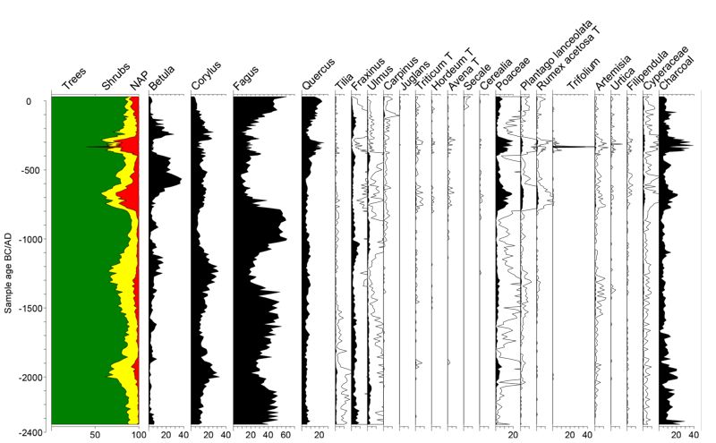
At Großer Ursee four NAP peaks are visible during the Iron Age (Fig. 17). The first dates to the Hallstatt period and is slight and brief (maximum 8.3% NAP). The second and third, separated only by a slight dip in NAP, have 11.3% and 14.4% NAP as maxima. They date from the early La Tène period. The fourth, lasting into the middle or late La Tène, scores 22.1%. They indicate 10%, 18%, 25% and almost 50% deforestation.

Discussion
Iron Age crop farming
Mining, early industrial activities and craftsmanship notwithstanding, the basis of Iron Age economics was agriculture. The traditions of crop production went back to LBA, using a broad mixture of cereals, pulses, and oil- and fibre plants. Beside at least seven different cereals, five pulses were in use, in addition to the long-known Pisum sativum and Lens culinaris, Vicia faba – since LBA – and, rather surprisingly – Vicia ervilia and Cicer arietienum, which are thought to need warm climates during their vegetation period. Pulses have not only the advantage of high protein content, but also of supplying themselves with nitrogen and furthermore increasing the soil’s fertility. To use this quality, it is necessary to cultivate them not separately in gardens but in the field, integrating them into a crop rotation system. But mixed cultivation together with cereals is also possible. Besides, after the Neolithic-grown Linum usitatissimum and Papaver somniferum, Camelina sativa became very important during the Iron Age.
Crop production took the form of extensive ard cultivation. Soil fertility was maintained by crop rotation, short fallow phases with animal browsing, but most probably without manuring, i.e. application of organic matter obtained from animal dung and organic litter by composting (Tserendorj et al. 2021). Obviously, rather long fallow phases enabled the soil to recover its fertility by accumulation of organic matter, creating less strained conditions for crop cultivation than in historical times.
The wet conservation conditions in the Heuneburg ditches yield evidence of garden plants and garden culture. Besides Anethum graveolens, Apium graveolens and Petroselinum crispum, in use in central Europe since the Late Neolithic, Satureja hortensis and Ruta graveolens were cultivated. Evidence for fruits and nuts is rare. Apart from – most probably imported – Ficus carica at Hochdorf (Schatz & Stika 2009), there is pollen evidence of Juglans regia at the Glauberg and Heuneburg. A grain of Castanea sativa in the Speckhau tumulus 17 cauldron should be regarded with restraint. Evidence for Vitis vinifera originates most probably from wild grapes.
It is difficult to determine whether all plants mentioned were produced and consumed in all sites and regions, because evidence is lacking. In comparison with the medieval situation, we can suppose common knowledge of useful plants and also widespread cultivation, but with different emphasis, depending on the local climatic and edaphic situation. Similar patterns had occurred in LBA, when for example Hordeum and millets were more common in warm and dry climates, versus Triticum spelta in colder climates (Rösch 1996).
Crop and animal husbandry with extensive ard cultivation and extensive woodland grazing caused deforestation in the Iron Age as in the Bronze Age and in historical periods. In the pollen record, deforestation is indicated by an increase in non-arboreal pollen and a decrease in arboreal pollen. Until the beginning of the Neolithic, Central Europe was totally covered by woodland, resulting in non-arboreal pollen of 5% and less. In a totally deforested European landscape with only small groups or single trees and shrubs left, arboreal pollen still accounts for between 30 and 50%, because most trees and shrubs have a much higher pollen production and dispersion than most herbs.
Looking at the on-site pollen spectra of the Heuneburg, deforestation between more than 80% and nearly 100% can be deduced (Fig. 12). But with on-site pollen it is difficult to assess the area represented. A comparison with off-site results is often difficult. At the Ipf, 28% NAP in the Trochtelfingen profile indicates deforestation of nearly 50% (Krause et al. 2010). We must keep in mind, that – in contrast to the Heuneburg and Oberschwaben pollen analyses – Poaceae are excluded from the pollen sum. If included, the degree of deforestation would be much higher, about 80% or more.
In the limnic profiles from Königseggsee, Stadtsee and Großer Ursee, deforestation rates for the Hallstatt period between 10 and 50% can be estimated (figs 15-17). On the Wetterau plain, near the Glauberg, the Mönchborn profile, close to the Vogelsberg mountains, indicates 29% NAP (without Poaceae) and so deforestation of about 90% and the Salzwiese profile with 43% NAP (without Poaceae) perhaps 100% deforestation (Stobbe 2008). Working with fen peat, it is necessary to exclude the Poaceae from the pollen sum, because they are partly local. When they are excluded, the indicated deforestation is too low, because a not exactly known part of them originate from the surrounding landscape, indicating its partial openness. A direct comparison in terms of deforestation with pollen results from lakes or bogs, where the Poaceae are included in the pollen sum, is difficult. Until recently, no limnic sediments with a good pollen record from the warm landscapes with fertile soils of the region occupied by the western Hallstatt culture were known.
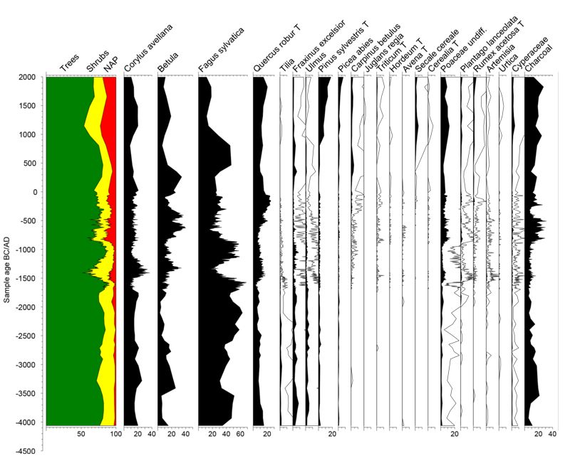
Now we can argue using such a profile. A few years ago, we took cores from ponds of the monastery of Maulbronn to study the medieval landscape by pollen analysis (Rösch 2013, Rösch et al. 2017). This monastery is situated on the boundary between the Stromberg Keuper (Triasic) hills and the loess-covered Kraichgau plain. In the largest of these ponds, the Aalkistensee, sedimentation began as early as the late third millennium BC. Obviously the monks enlarged and deepened an already existing natural lake, formed in an outwash hollow of Triassic sediments. With the exception of the Migration Period where the NAP percentages dropped briefly to 15%, and the MBA, where they dropped briefly to 7%, they are always between 25 and nearly 65%, Poaceae included. Apart from the medieval period, the highest NAP percentages occur during EBA and Ha C (more than 50%). During the Hallstatt C and La Tène periods, the NAP percentages are about 25%, indicating about 50% deforestation. Looking at southwest German landscapes with good off-site pollen evidence, we can observe, at western Bodensee, Hallstatt and La Tène NAP between 10 and 30% in eight profiles showing a very different pattern in time (Rösch et al. 2014). In the northern Schwarzwald (Black Forest), seven profiles from small lakes show NAP between 10 and 20%, again not correlated in time (Rösch et al. 2014). The estimated deforestation would have been between 20 and 60% at the Bodensee and 20 to 40% in the northern Schwarzwald. Preliminary results from the southeastern and southern Schwarzwald indicate even less deforestation than in the northern Schwarzwald (Knopf et al. 2019).
To sum up, there was intense deforestation in the Iron Age in southwest Germany resulting in 20 to 60% open land and even more in the loess landscapes. The differences between landscapes suitable for agriculture and landscapes less suited to it like the Schwarzwald are smaller than expected. In the northern Schwarzwald the surprisingly intense deforestation was caused by mining, especially by the subsistence husbandry of the miners (Gassmann et al. 2006).
The main difference between agrarian landscapes, perhaps to be called ‘central landscapes’ to distinguish them from marginal landscapes, is less the degree of maximum deforestation and more the chronological patterns of deforestation and resilience. Whereas in the marginal landscapes short-term clearing phases of a few centuries or even less were regularly interrupted by phases of woodland regeneration, in the central landscapes human impact remained strong, often for several centuries or more, and no woodland regeneration is visible. The length of regeneration phases can be evaluated by vegetation regeneration phases indicated in the pollen record (Müller 1962). The first clearly visible stage is a Betula peak. Betula is a woodland pioneer that can colonize abandoned fields. First, short time stages with ruderals and/or Salix and Rubus may be lacking or are often not visible in the pollen record. Betula has a life span of a century or less, but even after ten years, long-lived forest trees like Fagus or Abies can germinate and develop under the canopy of Betula. After several decades they overgrow and replace Betula. Therefore a regeneration phase between two clearing phases indicated only by a Betula peak lasted for a time of less than one century, most probably not much more than 50 years. When a Fagus or Abies phase follows between the Betula and the next clearing phase, the regeneration phase was longer, perhaps a century or more. To determine its length, a good time model based on radiocarbon dates or on annually laminated sediments is necessary.
References
- Arnold, B. and Murray, M.L., ed. (forthcoming): “A Landscape of Ancestors: Archaeological Investigations of Two Iron Age Burial Mounds in the Hohmichele Group”, Baden-Württemberg, Forschungen und Berichte zur Vor- und Frühgeschichte in Baden-Württemberg, Stuttgart.
- Behre, K.E. (1992): “The history of rye cultivation in Europe”, Vegetation History and Archaebotany, 1, 141-156.
- Brombacher, C., Jacomet, S. and Haas, J.N., ed. (1993): “Festschrift Zoller, Beiträge zu Philosophie und Geschichte der Naturwissenschaften, Evolution und Systematik, Ökologie und Morphologie, Geobotanik, Pollenanalyse und Archäobotanik”, Dissertationes Botanicae, 196.
- Bronk Ramsey C. (2009): “Bayesian analysis of radiocarbon dates”, Radiocarbon, 51, 1, 337-360.
- Drauschke, J., Prien, R. et Reis, A., ed. (2014): Küche und Keller in Antike und Frühmittelalter, Tagungsbeiträge der Arbeitsgemeinschaft Spätantike und FrühmittelalterStudien zu Spätantike und Frühmittelalter Hamburg 6.
- Ellenberg, H., Weber, H.E., Düll, R., Wirth, V., Werner, W. and Paulißen, D. (1992): “Zeigerwerte von Pflanzen in Mitteleuropa”, Scripta Geobotanica, 18.
- Fischer, E., Rösch, M., Sillmann, M., Ehrmann, O., Liese-Kleiber, H., Voigt, R., Stobbe, A., Kalis, A.E.J., Stephan, E., Schatz, K. and Posluschny, A. (2010): “Landnutzung im Umkreis der Zentralorte Hohenasperg, Heuneburg und Ipf. Archäobotanische und archäozoologische Untersuchungen und Modellberechnungen zum Ertragspotential von Ackerbau und Viehhaltung”, in: Krausse, ed. 2010, 195-265.
- Fiorentino, G., Caracuta, V., Primavera, M. and Bittmann, F., ed. (2021): Proceedings of the 18th IWGP conference Lecce 2019, Vegetation History and Archaeobotany, [online] https://doi.org/10.1007/s00334-020-00814-x [consulted on March 4, 2021].
- Gassmann, G., Wieland, G. and Rösch, M. (2006): “Das Neuenbürger Erzrevier im Nordschwarzwald als Wirtschaftsraum während der Späthallstatt- und Frühlatènezeit”, Germania, 84, 2, 273-306.
- Grimm, E. (2016): Paleoclimatology Data, [online] https://www.ncdc.noaa.gov/paleo/tiliafaq.html [consulted on March 4, 2021].
- Kimmig, W. (1969): “Zum Problem späthallstattzeitlicher Adelssitze”, in: Otto & Herrmann, ed. 1969, 95-113.
- Knopf, T., Bosch, S., Kämpf, L., Wagner, H., Fischer, E,. Wick, L., Millet, L., Rius, D., Duprat-Qualid, F., Rösch, M., Feger, K.H. and Bräuning, A. (2016): “Archäologische und naturwissenschaftlichen Untersuchungen zur Landnutzungsgeschichte des Südschwarzwaldes”, Archäologische Ausgrabungen in Baden-Württemberg, 2015, 50-55.
- Knopf, T., Fischer, E., Kämpf, L. Wagner, H., Wick, L., Duprat-Qualid, F., Floss, H., Frey, T., Loy, A. K., Millet, L., Rius, D., Bräuning, A., Feger, K.-H. and Rösch, M. (2019): “Archäologische und naturwissenschaftliche Untersuchungen zur Landnutzungsgeschichte des Südschwarzwalds”, Fundberichte aus Baden-Württemberg, 39, 19-101.
- Körber-Grohne, U. (1985): “Die biologischen Reste aus dem hallstattzeitlichen Fürstengrab von Hochdorf, Gemeinde Eberdingen, Kreis Ludwigsburg”, Hochdorf 1, Forschungen und Berichte zur Vor- und Frühgeschichte Baden-Württemberg, 19, 85-265.
- Körber-Grohne, U. and Vorwohl, G. (1985): “Wieviel Honig war in dem Kessel?, Hochdorf 1, Forschungen und Berichte zur Vor- und Frühgeschichte Baden-Württemberg, 19, 98.
- Krause, R., Stobbe, A., Euler, D. and Fuhrmann, K. (2010): “Zur Genese und Entwicklung des frühkeltischen Fürstensitzes auf dem Ipf bei Bopfingen (Ostalbkreis, Baden-Württemberg) und seines Umlandes im Nördlinger Ries”, in: Krausse, ed. 2010, 169-207.
- Krausse, D., ed. (2010): Fürstensitze und Zentralorte der frühen Kelten, Forschungen und Berichte zur Vor- und Frühgeschichte in Baden-Württemberg 120, Teil 2.
- Kreuz A. et Schäfer, E. (2002): “A new archaeobotanical database programme”, Vegetation History and Archaeobotany, 11, 177-179.
- Liese-Kleiber, H. (1991): “Züge der Landschafts- und Vegetationsentwicklung im Federseegebiet, Neolithikum und Bronzezeit in neuen Pollendiagrammen”, Berichte der Römisch-Germanischen Kommission, 71, 58-83.
- Liese-Kleiber, H. (1993): “Pollenanalysen zur Geschichte der Siedlungslandschaft des Federsees vom Neolithikum bis ins ausgehende Mittelalter”, in: Brombacher et al., ed. 1993, 347-368.
- Menke, B. (1995): “Vegetations- und Bodenentwicklung im Bereich der celtic fields im Gehege Ausselbek bei Ülsby, Kreis Schleswig-Flensburg”, Offa, 52, 7-28.
- Müller, H. (1962): “Pollenanalytische Untersuchung eines Quartätprofils durch die spät- und nacheiszeitlichen Ablagerungen des Schleinsees (Südwestdeutschland)”, Geologisches Jahrbuch, 79, 493-526.
- Nessel, B., Heske, I. and Brandherm D., ed. (2014): Ressourcen und Rohstoffe in der Bronzezeit, Nutzung – Distribution – Kontrolle, Arbeitshefte zur Bodendenkmalpflege in Brandenburg, 26.
- Oeggl, K., ed. (2005): A tribute to Sigmar Bortenschlager on the occasion of his 65th birthday, Vegetation History and Archaeobotany Heidelberg 14.
- Otto, K.H. and Herrmann, J., ed. (1969): Siedlung, Burg und Stadt. Studien zu ihren Anfängen (Festschr. P. Grimm), Deutsche Akademie der Wissenschaften, Schriften der Sektion Vor- und Frühgeschichte 25.
- Rösch, M. (1994): “Gedanken zur Auswirkung (prä)historischer Holznutzung auf Wälder und Pollendiagramme”, in: Lotter & Ammann, ed. 1994, 447-471.
- Lotter, A.F. and Ammann, B., ed. (1994): “Festschrift Gerhard Lang, Beiträge zur Systematik, und Evolution, Floristik und Geobotanik”, Vegetationsgeschichte und Paläoökologie, Dissertationes Botanicae, 234.
- Rösch, M. (1995): “Archäobotanische Untersuchungen in der spätbronzezeitlichen Ufersiedlung Hagnau Burg (Bodenseekreis)”, Siedlungsarchäologie im Alpenvorland, 4 / Forschungen und Berichte zur Vor und Frühgeschichte Baden Württemberg, 47, 239 313.
- Rösch, M. (1999): “Evaluation of honey residues from Iron Age hill-top sites in south-western Germany: implications for local and regional land use and vegetation dynamics”, Vegetation History and Archaeobotany, Heidelberg, 8, 105-112.
- Rösch, M. (2002): “Der Inhalt der beiden Bronzekannen”, in: Das Rätsel der Kelten vom Glauberg, Glaube – Mythos – Wirklichkeit, 119-120.
- Rösch, M. (2005): “Pollen analysis of the contents of excavated vessels – direct archaeobotanical evidence of beverages”, in: Oeggl, ed. 2005, 179-188.
- Rösch, M. (2013): “Die Weiher des UNESCO-Welterbes Kloster Maulbronn als wirtschafts- und umweltgeschichtliche Archive”, Archäologische Ausgrabungen in Baden-Württemberg, 2012, 71-75.
- Rösch, M. (2014): “Direkte archäologische Belege für alkoholische Getränke von der vorrömischen Eisenzeit bis ins Mittelalter”, in: Drauschke et al., ed. 2014, 305-326.
- Rösch, M., Fischer, E., Kleinmann, A., Lechterbeck, J., Tserendorj, G. and Wick, L. (2014): “Bronzezeitliche Landnutzung im diachronen Vergleich – Fallbeispiele aus Südwestdeutschland”, in: Nessel et al., ed. 2014, 13-27.
- Rösch, M., Fischer, E. and Kury, B. (2017): “Die Maulbronner Klosterweiher – Spiegel von vier Jahrtausenden Kulturlandschaftsgeschichte”, Denkmalpflege in Baden-Württemberg, 46/4, 282-287.
- Rösch, M. (forthcoming): “Pflanzenreste aus Tumulus 17, Grab 1”, in: Arnold & Murray, ed. forthcoming.
- Rösch, M, Stojakowits P. and Friedmann A (2020): “Does site elevation determine the onset and intensity of human impact? Pollen evidence from southern Germany”, Vegetation History and Archaeobotany, [online ] https://doi.org/10.1007/s00334-020-00780-4 [consulted on june 2 2021]
- Schatz, K. and Stika, H.-P. (2009): “Hochdorf VII, Naturwissenschaftliche Untersuchungen zur frühen Eisenzeit im mittleren Neckarraum”, Forschungen und Berichte zur Vor- und Frühgeschichte in Baden-Württemberg, 107.
- Schönfelder, H. and Haeupler, P. (1988): Atlas der Farn- und Blütenpflanzen der BRD, Stuttgart.
- Sebald, O., Seybold, S., Philippi, G. and Wörz, A. (1990-1998): Die Farn- und Blütenpflanzen Baden-Württembergs, I-VIII, Stuttgart.
- Smettan, H. (2010): “Die Landschaftsgeschichte im Umfeld der Heuneburg/obere Donau. Ein Beitrag zur Wald, Moor- und Besiedlungsgeschichte”, Fundberichte aus Baden-Württemberg, 31, 115-264.
- Stobbe, A. (2008): “Die Wetterau und der Glauberg – Veänderungen der Wirtschaftsmethoden von der späten Bronzezeit bis zur Frühlatènezeit”, in: Frühe Zentralisierungs- und Urbanisierungsprozesse, zur Genese und Entwicklung frühkeltischer Fürstensitze und ihres territorialen Umlandes, Kolloqium des DFG.Schwerpunktprogramms 1171 in Blaubeuren, 9.-11. Oktober 2006, Forschungen und Berichte zur Vor- und Frühgeschichte in Baden-Württemberg, 101, 97-114.
- Styring, A., Rösch, M., Stephan, E., Stika, H.P., Fischer, E., Sillmann, M. and Bogaard, A. (2017): Centralisation and long-term change in farming regimes: Comparing agricultural practices in Neolithic and Iron Age south-west Germany, Cambridge University Press, [online]
https://www.cambridge.org/core/journals/proceedings-of-the-prehistoric-society/article/centralisation-and-longterm-change-in-farming-regimes-comparing-agricultural-practices-in-neolithic-and-iron-age-southwest-germany/360AC876635642E5A833A23D13132729 [consulted on march 4 2021]. - Tserendorj, G., Marinova, E., Lechterbeck, J., Behling, H., Wick, L., Fischer, E., Sillmann, M., Märkle, T. and Rösch, M. (2021): “Intensification of agriculture in southwestern Germany between Bronze Age and Medieval period, based on archaeobotanical data from Baden-Württemberg”, Vegetation History and Archaeobotany, 30.
- Willerding, U. (1986): “Zur Geschichte der Unkräuter Mitteleuropas”, Wachholtz, 382.