


Introduction
This chapter presents the results of recent extensive high-resolution magnetic surveys of the landscape associated with the princely site of Vix and Mont Lassois with its remarkable architectural remains and submontane necropolis. Current investigations focus on the area around this ancient trading hub from the Late Bronze Age through the Hallstatt Culture and into the La Tène period.
So far, archaeological investigations have shaped detailed ideas about the development of society and its ritual and mortuary practices, but most of the landscape between the monuments has not been explored thoroughly.
Nowadays, a set of state-of-the-art methods and tools is available with which to identify hidden structures in a cost-effective and, at the same time, non-destructive way. While early aerial photography paved the way, enhanced by satellite imagery and LiDAR, geophysical surveys provide insights into internal structures of monuments and – on a landscape level – into large and complex systems originally shaped to express power and ritual beliefs.
The results of large scale area surveys also contribute to our understanding of needs for the future management of the properties and highlight the challenges of making these hidden landscapes visible to the public at large. Geophysical anomalies can be caused by different archaeological and non-archaeological features and their interpretation and dating rely on comparisons and results from other techniques such as field walking and excavations. The interpretations presented here are based on current archaeological knowledge and may change as and when new data become available.
As part of the Programme Collectif de Recherche (PCR) “Vix et son environnement”, the German Archaeological Institute (DAI) began large-scale, high-resolution geomagnetic prospections at Vix in 2013, continuing through 20171 (Fig. 1).

Based on known features and evidence from remote sensing, the aim was to cover as much of the immediate vicinity of the known monuments as possible and investigate the surroundings in a comprehensive way to identify not only representative monuments but also any other features related to the princely site. However, the detailed selection of fields to survey often depended on accessibility with respect to permissions and farming activities.
During its long research history, Mont Lassois has been the focus of different excavation and survey projects.2 The DAI was able to build on the resulting vast archaeological knowledge when looking for hitherto unknown features. The geomagnetic survey data together with parts of the LiDAR data and aerial imagery collected during the last decades were analysed as part of a master’s thesis.3
Equipment and Data Processing
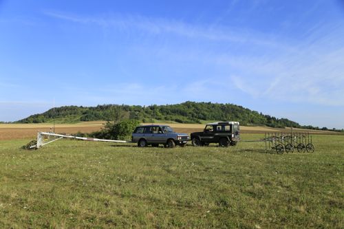
The extensive coverage of the recent investigations was made possible thanks to a vehicle-towed 16-probe SENSYS MX® V2 fluxgate magnetometer system,4 which had previously been used successfully at several other well-known sites, e.g. the World Heritage Sites of Stonehenge and Avebury in the UK.5 The complete system consists of 16 fluxgate gradiometer probes mounted onto a carrier of nonferrous material, which can be attached to an all-terrain vehicle via a 7 m long drawbar.
With its precise DGPS positioning (precision of about ±1 cm), 4 m span, 25 cm crossline sensor spacing, and its measurement frequency of 20 Hz, enabling a potential operational speed of up to 18 km/h, this system allows fast, precise and high-resolution geomagnetic prospection. Daily coverage can reach up to 28 ha, but normally varies between 10 and 20 ha since the size and shape of the survey area, as well as ground conditions, impact the survey speed considerably.
Since 2017 the DAI has used a second MX® V3 magnetometer system. The technical specifications are mostly the same, but the sampling rate has been enhanced to 200 Hz. Significant changes, however, include a much lighter frame and shorter drawbar, allowing more precise manoeuvring and easier handling. The system is also convertible into different configurations, including a five-probe hand-pushed version. For the first time, in 2017, the DAI conducted a survey in ’duplex mode’, i.e. running two systems at the same time (Fig. 2).
The data processing is managed by the manufacturer’s proprietary software6 or alternatively by a tool set developed by the DAI, which allows for direct integration into open source GIS, simultaneously allowing the application of various filtering techniques.7 Combination or blending of the dynamically adjustable magnetograms with other sources, e.g. aerial images or LiDAR, thus becomes an easy task and achieves results of additional value.
Necropolis
On the left bank of the Seine
The area between the southern foot of Mont Lassois and the Seine, on the land plots Les Tillies and Les Herbues, has been at the centre of archaeological interest ever since R. Joffroy discovered the richly furnished burial in Tumulus 1 in 1953. It has therefore been the focus of frequent aerial and geophysical surveys.8 The latest summary and map overview of the known archaeological features in this area was published by F. Cruz.9 The purpose of the DAI survey was to identify the total extent of the necropolis and search for further burials (Figs 3; 4; 5; 6). Tumulus 1 itself (T1) has already been described at length in various publications10 and remains poorly visible in the magnetic data.11 Tumulus 5 (T5) is known from Von der Osten-Woldenburg’s survey but so far undated. Tumulus 7 (T7) was detected by aerial photography and confirmed by geomagnetic surveys and excavation by F. Cruz in 2009, dating it to 2684 ±32 calBP (95.4%).12 The circular ditches of Tumulus 5 and Tumulus 7 are clearly visible as positive anomalies in the magnetogram. There is another much fainter, circular, positive anomaly (T10) which might indicate a small burial mound with an outer diameter of 10.8 m, about 70 m north of Tumulus 7. Further north, a cluster of small, round positive anomalies, identifiable as pits, appears, that probably indicate a burial mound with a surrounding stone circle (T11). A third tumulus, 80 m south of Tumulus 5, is visible as a semi-circular anomaly of changing magnetic values (T12).


Tumulus 2 is visible in the magnetogram (T2), together with traces of its excavation,13 especially the cross section of the trench and several survey pins. Southeast of the tumulus several strong round anomalies (P1), most probably pits filled with highly magnetized material may be interpreted as the remains of fireplaces.
The same area was also used as a burial place during the La Tène period. The ditched enclosure (E9) near Tumulus 1, which is very prominent in the magnetic data, was already known from earlier geomagnetic surveys.14 Judging by its dimensions and layout, it is most likely a La Tène period burial enclosure, comparable to those observed a few hundred metres further upstream on the Seine.
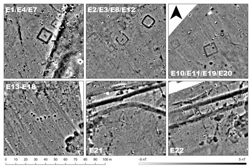
Here, in the field called Les Tillies, nine square enclosures dating to the La Tène period are visible in the magnetogram (E1-E4, E7-E8, E10-E12; Figs 4; 7). All of them were already observed in other surveys. Two further enclosures (enclos 5-6) in the area were excavated15 and do not appear in the magnetic data. The latest geomagnetic survey does not indicate that this La Tène necropolis continues westwards, but in the south-eastern corner of the field, close to Tumulus 2, are three quite strong anomalies of similar appearance (E13-E15). Another group of fainter features (E16-E18) may represent three further enclosures of the same type, indicating that the cemetery continues in the direction of the river. Next to the two enclosures near the road (E10-11), which are known from earlier surveys, two more enclosures of similar dimensions appear in the new data (E19-E20). Near them several pit like structures, possibly indicating burials, become apparent, as has already been observed in the southern part of the necropolis. This cluster of now four enclosures suggests that the La Tène necropolis extends further north into the field across the road.
There are several linear features in the magnetic data that indicate ditches. It has previously been speculated that the most notable of these (D1) was the enclosure of the necropolis. As the geomagnetic survey shows, it continues farther in a south-westerly direction than expected. Since the necropolis does not appear to extend this far, a connection between the necropolis and the ditch seems questionable. North of Tumulus 2, two parallel lines seem to connect with D1 (D2-3) but are much fainter and might indicate an old field path. A second, long ditch-like feature (D4) runs SW-NE but it too fails to correlate with any of the modern field boundaries, while several other features of ditch-like appearance seem to be aligned with field boundaries visible in old photographs
(D5-9).
Further up the Seine, near Sainte-Colombe, an aerial photograph taken by René Goguey in 1991 shows an enclosure, clearly visible as a snow mark. This enclosure was investigated through a sounding carried out by F. Cruz in 2009 dated by 14C to 204 ± 38 calBP (94.4%), but not containing any finds from which its function might be interpreted.16 A feature in the magnetogram of the adjacent area can be interpreted as a ditch forming a roughly rectangular enclosure of 23.7 x 32 m in field 2016-12 (E24). The shape and size of this structure are similar to the La Tène enclosure sounded by Cruz.
Extension on the right bank of the Seine
To date, archaeological investigations have concentrated on the left bank of the Seine. However, on the other side of the river, an aerial photo taken by R. Goguey in 1993 shows at least three vegetation marks, indicating the circular ditches of a burial mound of 8-11 m in diameter.17 These three features are, however, not visible in the magnetic data, although two other quite clear (T13-14, Figs 3; 6) and two more vague (T15-16) rounded ditches were detected in the same field (2017-09). They do not correlate with those visible in the aerial image in either size or position, and in one case they even intersect.
The hypothesis of a necropolis on the right bank of the Seine is supported by two features visible in the magnetic data of field 2015-10 (E21-22). Two faint positive features indicate ditches, each roughly forming a square with sides 9-11 m long. The size and shape are comparable to the known La Tène period enclosures from the Les Tillies necropolis (cf. E2-4). This would show that the right bank necropolis exhibits the same diachronic pattern of usage as the left bank necropolis.
About 850 m downstream, in a field called Le Buisson Richard, two aerial images taken by R. Goguey in 1996 show several positive crop marks, indicating, among other things, two large, curved features, representing circular ditches and a couple of small features, indicating pits. The corresponding magnetogram shows some of these features, although not as clearly (Figs 5; 6) and generally indicates that the crop marks were more likely caused by geomorphological structures. Several new features are visible in the geomagnetic survey. In the southern part of the field, a D-shaped structure indicates a ditch (D10). In the vicinity of the eastern part of this ditch, there are several probable pits, arranged in two dense clusters (P2). Two more or less parallel linear ditches are visible further north, again with several probable pits around them (P3). The most interesting anomalies are two round ditches, one forming a circle, the other being partly visible in the northern half (T17-18). Magnetic values and dimensions of these features are comparable to the circular ditches around smaller burial mounds known from the other bank of the Seine. A quite faint roundish feature further south might indicate a third, somewhat larger tumulus (T19).
The La Garenne and La Butte tumuli
The magnetogram of field 2013-03 shows the remains of the Tumulus de la Butte (T20) with the same detail as earlier surveys18 (Figs 8; 9), proving that the large, high-speed MX system achieves at least the same level of detail as manual systems. The burial mound appears as two concentric semicircles of slightly lower magnetic values of 26 m and 36–38 m in diameter, respectively. An opening in the north-eastern circular structure was probably caused by the excavation trench. Two roughly circular positive features within the tumulus correspond to similar features visible in the resistogram by H. von der Osten-Woldenburg and are probably part of the internal construction, possibly two separate burial chambers.19 A third positive, circular feature of 10 m in diameter on the southern edge of the burial mound corresponds to a feature of higher electrical resistance in the resistogram. H. von der Osten-Woldenburg interprets this as a dump of stones left there after the excavation of 1863, but in combination with the clear circular anomaly visible in the magnetogram this may equally reflect the remains of an earlier burial mound, on top of which the larger tumulus, which is still visible today, was erected, as was the case with Tumulus 2.

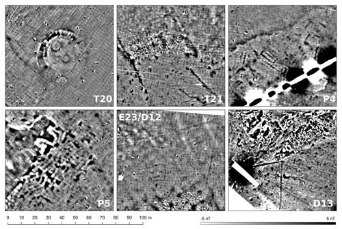
The la Garenne burial mound could be located based on the Napoleonic Cadastral Map20 and should be visible in the magnetogram of field 2013-02. At the exact location given by Stréer and Chaume no anomaly indicates a tumulus. The small rectangular feature (E23) in this spot probably represents an enclosure of later date. The only feature vaguely similar to a tumulus apparent in the magnetic data lies about 70 m south-west of the location derived from the Napoleonic map (T21). Here, a 2.6 m wide negative anomaly forms a segment of a circle with a positive anomaly on its inner side. The structure of these anomalies is quite similar to the outer ring of the Tumulus de la Butte and the diameter of the reconstructed circle (40 m) seems to fit the description of the Tumulus de la Garenne.21 Since the geomagnetic anomaly is right on the edge of a large geological structure, its interpretation remains uncertain. Further investigations with GPR should be considered for the small area covering both possible locations of the tumulus.
Two more features of unclear origin can be observed in this area, both distinct clusters of mostly positive anomalies (P4-5), one in each field of the area. P4 shows three features of rectangular appearance. A ditch-like anomaly forms an open square with sides about 9 m long, which might represent another burial enclosure dating to the La Tène period. To its south-west is a second rectangular ditch-like anomaly of 10.8 x 4.7 m with a linear positive anomaly in its centre, running parallel to the long sides. This might represent a two-naved building without identifiable post holes. Directly south of this structure is a rectangular cluster of small, round, positive anomalies, which might represent post holes. In this case, the entire structure could represent a second two-naved building of similar dimensions. In the case of P5 no clear structures become apparent, but here, too, several large pit-like features reflect archaeological structures.
There are several linear ditches visible in the area. Three segments of ditch-like anomalies form a large right angle (D11) on the southern border of 2013-02, probably indicating the boundaries of an old field parcel, although they do not correspond to the field borders visible in the IGNF orthophoto of 1953. A second ditch can be observed on the northern edge of 2015-03, forming an acute angle (D12). Apparently enclosed within this ditch is a smaller enclosure forming an open rectangle (E23), possibly a burial enclosure or small building. A third angled ditch is visible in the south-western curve of the same field (D13), where the orthophoto shows a small copse.
It seems reasonable to assume that the other ditches (D14-17) reflect old field boundaries, since they are very long and straight, but they do not correspond to the field boundaries of the 1940s and 1950s. There is another linear feature visible as a strong dipole anomaly in field 2013-03 (H1). The orthophoto revealed this feature to be an old track, still in use in the 1950s, which seems to have been paved with slag from the iron refining factory adjacent to the field; remains of this can still be found in large quantities in the field. The part south of the path was incorporated into the recent field later, and traces of agricultural activities are clearly visible in the magnetogram of this section.
There are several other modern disturbances in the area, the most obvious being the elongated dipole anomaly (H2) caused by a modern gas pipeline connected to the iron factory, running straight through the potential archaeological site P4.
Cérilly
The Tumulus la Motte de Cérilly is located 5 km south-west of Mont Lassois and, with an estimated original maximum diameter of 60 m and a height of 14-15 m, is considered one of the largest Iron Age period burial mounds in Europe. However, it was severely damaged by deliberate levelling and agriculture. Although it has been sounded twice, in 1863 and 1965, its precise dating is still unknown.22 Since the general structure of the tumulus is already well known from intensive geophysical surveys by Harald von der Osten in 1998,23 the main purpose of the DAI’s survey was to search for any traces of further human activity in its surroundings. In 2017, 65.4 ha were surveyed covering the burial mound itself and areas mainly towards its north, east and south (Fig. 10), showing a clear image of the tumulus (T22) with a distinct, slightly oval ditch of 74 x 72 m (T22a) annexed by a square enclosure of 22 x 22 m in the north (T22b). The internal structure appears as a round cluster of both negative and positive anomalies surrounded by a faint linear feature of 55 m in diameter, which most probably originates from a wall thought to belong to the first phase of the mound.24 The anomalies inside are probably caused by internal features within the mound. The most apparent is the linear negative anomaly running from the south-west into the centre of the tumulus (T22c), which can be identified as the trench of the excavation by J. Joly in 1965.

The area shows prominent geological features, which coincide with a suspected old river bed already observed in the magnetograms near Étrochey. The Roman road, known to run in a south-west to north-east direction less than 100 metres north of the tumulus, is visible only as a long stretch of small dipolar anomalies, probably of modern origin, since a recent gravel track follows the direction of the ancient road. A small Roman building was detected in the northernmost corner of the surveyed area (see below).
Veuxhaulles
Several fields in the communities of Veuxhaulles-sur-Aube and Montigny-sur-Aube were surveyed during the last days of the campaign in 2017, focusing on the surrounds of the large Tumulus du Fourneau, which is thought to be a marker of Mont Lassois territory.25 A sounding of this burial mound in 1881 revealed a robbed central grave within a stone chamber of 10 m in diameter, a circular ditch, and a stone packing surrounding the mound, as well as a secondary grave without grave goods.26 The remaining goods of the central grave provided a dating to Ha D2/D3.27 No further investigation of this grave has been conducted and several questions regarding its inner structure remain unresolved.
The magnetogram (Figs 11; 12) revealed the underlying geology corresponding to the Carte Géologique de la France as well as several archaeological features. The prominent burial mound (T23) is visible as a faint, circular, positive structure of approximately 7 m in diameter surrounded by a slightly more positive feature of 12-13 m in diameter. The magnetogram resembles the description by M. Magdelaine, whose 2 m-wide excavation trench also becomes visible in the data, but there are no traces of the stone covering of the central tumulus in the magnetic data, probably because it was removed by the excavators. However, a new structure becomes apparent in the magnetic data, which does not seem to fit the nineteenth-century description of the monument. South-west of the tumulus, a broad, C-shaped negative feature (T23a) seems to indicate a large stone structure, possibly a pavement surrounding the tumulus. On the north-eastern side, the feature is less clear, but the structure may extend in this direction as well. Inside this C-shape is a faint positive anomaly, possibly representing another trench surrounding the known tumulus. Most prominent and surprising is a circular, negative feature of 11 m in diameter on the south-western edge of this structure with an oval, negative anomaly in its centre (T23b). It remains unclear whether these anomalies are traces of a preceding or secondary burial, perhaps with a stone burial chamber, or traces of earlier excavation/robbery activities. But well-known examples of multi-phased tumuli, like Tumulus 2 near Mont Lassois or the similar structure near the Tumulus de la Butte allow speculation about a second, perhaps undisturbed phase of this monument.
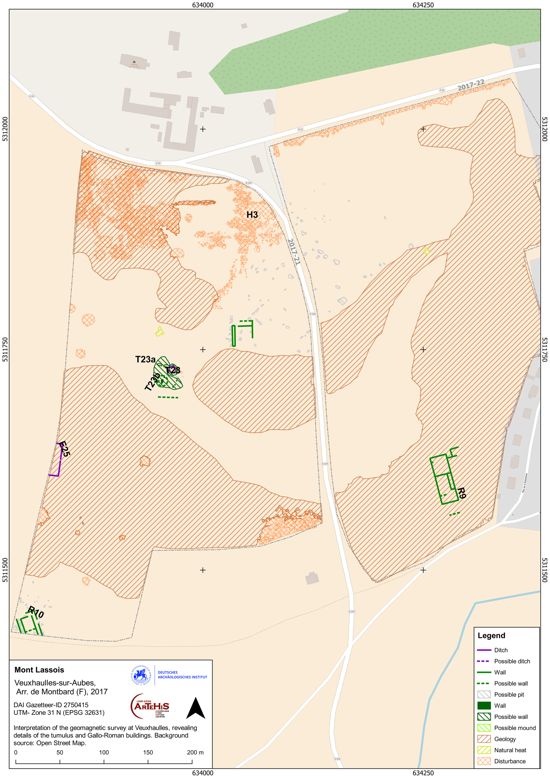
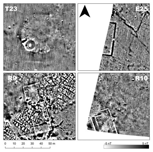
Apart from this tumulus no burial structures become apparent in the near vicinity. However, there are several unambiguously archaeological features apparent in the magnetic data. On the western edge of the survey area, parts of a rectangular enclosure (E25) were discovered. One side was fully recorded measuring 36 m in length (measurements were taken at the centre of the anomaly) and 0.8-1.8 m in width. It shows an opening or entrance of 2.3 m in width on this side. The similarity with the famous cult structure of Les Herbues,28 found at the foot of Mont Lassois, seems striking, although the newly discovered enclosure appears to be larger. The entire area is spotted with strong dipole anomalies, which are clustered most densely in the northern part of the eastern field (H3). These anomalies seem mostly to be caused by dense accumulations and scatters of slag from the iron production that must have taken place here judging from the place name Fourneau. This slag could also be seen on the ground, when surveying the field.
Settlement traces
There has been a lot of speculation about the existence and possible position of a lower or open settlement belonging to the Mont Lassois hilltop settlement. Although several places have been suggested,29 no larger settlement could be identified with certainty in any of them.30 The first real hint of a settlement extra muros was the excavation at Le Breuil by B. Chaume, N. Nieszery and W. Reinhard between 2013 and 2015,31 following an indication by an aerial photograph taken in the particularly dry summer of 2011.32 They uncovered traces of a Hallstatt period habitation and a possible La Tène period Viereckschanze, but given the comparatively small size of the excavation, it is still difficult to determine its size and function. One possible and well suited method of detection would be large-scale geophysical surveys, like the one conducted by the DAI.
The magnetic survey of field 2016-01 took place after the final campaign of these excavations (Figs 3; 13). The magnetogram shows only very faint features that could be interpreted (with much doubt) as ditches, were it not for the fact that their existence was confirmed by the excavation. A number of well identifiable pits, some of considerable size, could be detected (P6). Most interesting are three clusters of small positive features, indicating postholes, forming rectangular structures (B1-B3). B1 exhibits a weak signature but seems to form a part of the Hallstatt period building partly excavated in 2014/2015, suggesting a trapezoidal layout, measuring 8.5 x 5.2-6.2 m. Seven metres to the south-east, building B2 is indicated by at least 10 possible postholes forming a rectangular ground plan with a narrow rectangular expansion on its north-western edge of 14.8 x 4.7-6.3 m. The third building B3 – only 3.6 m from B2 – is indicated by eight small positive anomalies, forming a rectangle of 4.8 x 3.5 m. The size and general layout could point to an Iron Age date, but it is difficult to distinguish on the basis of these rather faint magnetic anomalies alone.
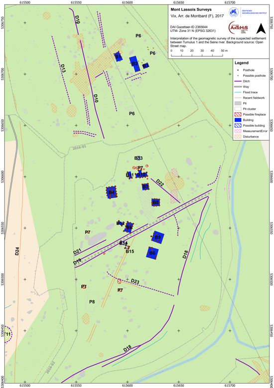
The most important discoveries made by the DAI surveys are traces of several other buildings in the adjacent field
2016-03. These buildings appear as clusters of postholes, though these are much clearer than the features described above. This discovery came as a surprise since no settlement had been indicated by aerial images or other means in this field before. At least 10, possibly 12 buildings are visible in the magnetogram, covering an area of about half a hectare. Including the three buildings observed in field 2016-01, the extent of the entire settlement would amount to approximately 200 x 100 m. A typological interpretation of geomagnetic features must naturally remain preliminary until confirmed by other methods.
However, when comparing the reconstructed ground plans from the magnetograms with typical Hallstatt period houses, strong similarities become apparent.33 The buildings of the Hallstatt period, known from other sites, can be summarized as one- to three-naved rectangular buildings of medium size (most commonly 77-100 m²) or small two-naved buildings.34 The two Hallstatt period buildings excavated on the plateau of Mont Saint-Marcel fall into the latter category35 and can be seen as the best comparable examples, since they are spatially closest and resemble B7 and B8 closely in both layout and dimensions. Based on this comparison it is assumed that the newly discovered buildings represent a Hallstatt period settlement.
Four types of buildings become apparent in the data which shall be discussed briefly (Figs 13; 14). Type A is a rectangular or square, three-naved building with densely set postholes (B4-B6). In the case of B4 at least 23 postholes could be identified, while B5 and B6 are less easily recognizable in the magnetic data and show only 14 and 10 postholes. Their sizes are quite uniform at 9.7-10.6 m long and 9.34-9.5 m wide, resulting in areas of 92-101 m². B4 stands out especially by its strong anomalies, indicating more massive post holes. This, together with the dense setting of the posts and the apparent lack of a fireplace, suggests it was a storage building.

Type B encompasses rectangular or square two-naved buildings (B7-B9), which are smaller than Type A measuring 6.3-10.2 x 5.8-6.9 m, covering an area of 36-70 m², and feature 9 (B7) to 14 (B9) postholes. They are therefore similar to the Maisons 1 and 2 discovered on the plateau. Based on the ground plan reconstructed from the excavation and the magnetogram, B1 probably falls into this category, too. Cluster B9 additionally contains a slightly larger and stronger positive anomaly near its western edge that may have been caused by a fireplace. This is the only possible fireplace within a building in this area and may hint at a residential function.
The two non-rectangular buildings B2 and B10 can be assigned to type C. Both have a long, narrow, one-naved basic layout, measuring 12-14.8 x 4.5-4.9 m. Both buildings have an additional annex, although in the case of B2 this might equally well be an incompletely preserved second nave, or an annex. B10, too, seems to have two additional posts in the middle of its northern façade, possibly forming a square annex of 3.6 x 4 m.
Type D contains two to five quite small rectangular buildings, constructed with four or six posts (B3, B11-B15). The buildings measure between 3.3 m and 6.5 m in length and between 2.6 m and 4 m in width and are comparable to the small four- and six-post storage buildings that were common in the Hallstatt period,36 but also in other periods.
Around the buildings several small, round, positive features indicate pits, as would be expected in a settlement context. Yet, some of the features show considerably higher readings than a ’usual’ pit (P7). These features might represent heated structures, most likely fireplaces. They are different from the ovens observed on the eastern foot of Mont Lassois37 probably because they derive from open fireplaces on a stone or earth bed rather than high-temperature ovens built out of baked clay. Another explanation may be, however, that these are indeed pits containing a particularly magnetized filling. A cluster of four large pit-like features with comparatively high readings on the western edge of field 2016-03 (P8) also indicates heated features, or large pits filled with such material.
Two linear features stand out for their very distinctive readings. One runs parallel to the modern course of the Seine for nearly 250 m with a quite regular width of 1-2 m (D18). This feature follows the course of a step in the terrain that is noticeable in the field and on the LiDAR. This step is assumed to have been formed by the Seine, while the linear, ditch-like feature may be the result of human activity, especially since both the step and the magnetic feature appear only in the area of the settlement. The feature may therefore represent the remains of a flood protection or construction stabilizing the bank. The second linear feature (D19) meets D18 at its northernmost point. It is formed by two parallel, ditch-like features enclosing an area of slightly lowered magnetic values, quite similar to the possible track D20. This potential traffic route does not appear in any aerial picture and therefore must have been abandoned before 1948; but since it does not align with the buildings of the settlement, and even crosses some of them, they are probably not contemporaneous. The linear, ditch-like feature D21 runs parallel to D19 and might therefore be contemporaneous with it, while D22-D23 run parallel or at right angles.
There are two features of similar appearance in the magnetogram of 2016-02 (Fig. 3). The western anomaly (D24) corresponds to an old field boundary visible in an aerial picture and was probably caused by a ditch marking this boundary. The other structure (D20) is far more regular, its edges running parallel at a distance of 4.9 m for more than 300 m and seems to continue to the south where it is visible as a crop mark in aerial photographs from 1963. The feature was interpreted by Cruz38 as an ancient, paved road, but von der Osten-Woldenburg saw it as a more recent field track or even a natural gravel accumulation washed up by the Seine.39 Considering the size and shape of the feature, interpretation as a track is more likely, but its dating would have to be assessed by excavation.
Synopsis of non-Iron Age features discovered
Traces of Roman settlements
The large-scale geomagnetic surveys revealed structures from different periods of time, ranging from Neolithic enclosures to modern mining pits and drainage systems. Since the scope of this paper is limited, only the Gallo-Roman features shall be highlighted. After the apparent reduction of settlement activities during the La Tène period,40 the area around Mont Lassois was settled again more densely during Gallo-Roman times,41 resulting in a comparatively large number of small, rural Gallo-Roman buildings scattered across the entire Châtillonnais, as well as several larger villae rusticae.42 Several of these sites were erected on top of earlier La Tène farmsteads and often combined architectural elements of both traditions.43 Gallo-Roman buildings are densely distributed in the region at almost regular intervals of about 1-1.5 km44 and connected by a tight network of roads and tracks that is known from this period, first mapped by R. Paris.45
Some Gallo-Roman remains were also found on Mont Lassois itself in different excavation trenches on the plateau and the slopes.46 Also, as indicated by the discovery of burials, Roman sherds and foundations, the village of Étrochey is most likely built on top of a Gallo-Roman settlement.47
The Gallo-Roman building (R1) next to the famous Tumulus 1 is visible in both earlier aerial and geophysical images;48 it was investigated by Olivier Dumay in 2003 and dated to the first to third centuries AD.49 Similar buildings are quite common in the region, where high-quality limestone is easily available. Dumay described a small earth cellar (1.6 x 1.5 m) discovered 40 m from the building. The magnetogram (Figs 3; 15) reveals several distinctive, positive pit-like features of about the same dimensions (P9) in the vicinity of the building, that indicate more storage pits or cellars. A linear structure (D25) running from the building in a NW-SE direction was interpreted by von der Osten-Woldenburg as a sewage ditch.50

A linear feature running through fields 2015-10 and 2015-12-15 appears to be an old road (Fig. 3), made up of a linear structure with slightly lowered magnetic readings and one – possibly two – parallel lines with raised magnetic values (R2) which can be interpreted as a street paved with diamagnetic material and a roadside ditch. It matches a linear structure of slightly raised elevation which becomes visible in the LiDAR-Scan. The map by R. Paris shows a Roman road crossing this area, but the survey data helped to determine its course more accurately.
A Gallo-Roman villa about 150 m south-west of Courcelles was discovered by René Goguey during an aerial survey in 1964.51 The image shows four rectangular structures (R3) visible as negative marks in the ripening crop, indicating shallow buried walls arranged around a central courtyard or building. The site was walked by Dumay in 2003/2004, who found bricks, limestone building elements, and pottery dating to the first half of the first century and to the fourth century CE.52
The geomagnetic survey (Fig. 15) confirms the building complex visible in the aerial image and helps clarify the architectural structure. As with the building near Tumulus 1, the limestone walls show up as negative linear anomalies in the data. Two rectangular structures in the western half of the building appear very clearly and are of identical proportions of 7 x 5 m. While the course of the walls can be tracked well for the south-western corner, the northern corner appears more like one solid anomaly, probably indicating parts of the collapsed wall that are still in place. The south-eastern part of the building becomes much less apparent than in the aerial photograph but is still visible as a faint, slightly blurred negative anomaly indicating another rectangular building or room of 6.3 m in width protruding 2.7 m from the central court. The north-eastern corner – already difficult to interpret from the aerial image – on the other hand appears very different in the magnetogram. The structure from the aerial survey interpreted as a rectangular room approximately twice the size of the other rooms does not show up in the magnetic data except for a large linear feature with blurred edges running along the entire eastern part of the building. This is most probably the trace of the outer eastern wall, although a rectangular corner at its southern edge might indicate a second court or large building, the remainder of which is not preserved.
The magnetogram reveals some architectural details that were not visible in the aerial image. On the northern side a rectangular protuberance of 3.4 x 5.3 m can be distinguished, although the full extent of this structure is not traceable in the magnetic data. This building confirms the original interpretation of four small rooms, one in each corner of the central courtyard/room. This courtyard appears more diverse in the geomagnetic survey, comprising a small rectangular feature on the western side and a wall running parallel to the southern outer wall of the courtyard.
Outside the building only a linear positive anomaly with a rectangular layout, corresponding to the south-western corner of the building, might represent a surrounding ditch. Its further course is difficult to trace but the very faint, linear feature running in an easterly direction might be its continuation. A second, much clearer linear feature running in the same direction can be observed about 10 m to the south.
In the eastern part of the field two linear positive anomalies mark two ditches running parallel at a distance of approximately 8 m (R4). The nature of the features and the distance suggest they can be interpreted as road side ditches. Since the course of this potential traffic route runs close to the Gallo-Roman farm building and leads to the north in the direction of the known Roman road from Lingonae (Langres) to Tornodurum (Tonnerre), it is very likely that it forms a connection between the farm and the main road.
Crop marks visible in aerial images of a field on the southern edge of Étrochey by R. Goguey in 1982 also seem to prove the existence of Gallo-Roman buildings. Therefore, in 2015 the DAI surveyed three fields (2015-22-24) in the area to shed new light on this possible settlement (Fig. 15). The structure R5 in field 2015-23 appears as one large cluster of linear, negative features, which – like the crop marks – seem to indicate walls, in this case probably made from local limestone. However, the features still do not form clear building floor plans as observed in fields mentioned above. There are also several positive features of approximately rectangular shape which again could derive from pits of old storage cellars. However, the entire area’s magnetic data is severely disturbed by underlying geological structures with similar anomalies. The long linear feature R6, on the other hand, appears clearly as a negative anomaly corresponding to the interpretation as a wall. An anthropogenic origin of these structures is very likely. Since the geological feature underlying the cluster contains high quality limestone that has evidently been mined in the Roman period, it may be some kind of mining structure perhaps containing workshop buildings. Features of similar appearance also group in a small cluster in field 2015-22.
In the northernmost corner of the surveyed area at Cérilly a small, square building of 13 x 13 m appears outlined in negative linear anomalies with a ditch on its western side, possibly indicating an enclosed area belonging to the building (R7; Fig. 15). On the building’s southern edge, three rooms of 3-4 m side length and with dark anomalies in their centres may indicate small storage rooms with cellars. Similar square, positive anomalies in the surroundings of the building could represent further cellars. Such cellars were observed e.g. at the small Gallo-Roman building near the Tumulus princier.
Traces of a possibly Roman structure have been located right below the northern summit of Mont Lassois (R8). In this area an almost E-W-oriented ditch-like structure, measuring 54 x 45 m and what appear to be limestone walls about 10 m apart on its eastern side, possibly represent a Gallo-Roman ferme indigène.
The survey near Veuxhaulles also shows at least two buildings (R9-R10) of considerable size (R9 approximately 55 m long, R10 > 30 m long), most probably dating to the Roman period (Figs 11; 12). Both buildings are visible as clear negative features, which can be associated with limestone architecture and reveal some details of their inner structure. If the dating to the Roman era proves to be correct, these buildings would show that the Roman vicus discovered and mapped by aerial archaeology53 extended further to the north than has been assumed until now.
Summary
The large-scale geomagnetic surveys conducted by the DAI in the vicinity of Mont Lassois have proved very efficient in terms of coverage and discovery. Overall, 80 field plots covering a total area of 690 ha were covered in 50 days in the field,54 during five campaigns. The high coverage rate and precision of the multi-sensor system resulted in high-resolution magnetograms of several large areas concentrated in the area south of the hill. These revealed 108 features, 80 of which were hitherto unknown (Fig. 16), increasing the number of sites in the area by about 80%. These date from the Neolithic to the modern period with a focus on several, probably Bronze Age/Iron Age cemeteries and settlements.

The most important results include the discovery of (1) a settlement of at least nine pole buildings, probably dating to the Hallstatt period at Le Breuil, (2) the confirmation of at least three burial mounds on the right bank of the Seine, accompanied by two La Tène period enclosures, as well as (3) at least five new La Tène period grave enclosures at the necropolis of Les Tillies. In combination with the Hallstatt and La Tène period settlement traces discovered during an aerial survey in 2011, and partly excavated in 2014/2015, the new settlement features at Le Breuil clearly indicate that an outer settlement to the Hallstatt period hilltop site indeed existed. Its exact function – dwelling, storage or market site – has to be determined through excavation.
The geomagnetic survey showed that Iron Age habitation of the Seine valley was far more intense than previously thought, despite very intensive archaeological work in this area and especially thorough and extensive aerial surveys. The environment, without any doubt, was more than a place for representative graves, but also background and support for the seat of power on top of the hill. Although the geomagnetic survey is not a representative sample of the whole region, since most of the survey fields were very close to the River Seine, it appears that the Iron Age sites cluster around the south of Mont Lassois, in the immediate vicinity of running water. Whether this observation is due to a higher rate of discovery in these areas, the economic importance of the river, or to cultural preferences of the Iron Age people, remains to be validated through further investigations, ideally on a supra-regional scale.
References
- Bénard, J., Mangin, M., Goguey, R. and Roussel, L., ed. (1994): Les agglomérations antiques de Côte-d’Or, Annales littéraires 522, Paris.
- Bersu, G. (1930): “Vorgeschichtliche Siedelungen auf dem Goldberg bei Nördlingen”, in : Rodenwaldt, ed. 1930, 130‑143.
- Brun, P. and Chaume, B., ed. (1997): Vix et les éphémères principautés celtiques : les VIe et Ve siècles avant J.-C. en Europe centre-occidentale, Actes du colloque international de Châtillon-sur-Seine, 27-29 octobre 1993, Archéologie d’aujourd’hui, Paris.
- Chaume, B., ed. (unpublished): Rapport d’activité triennal du PCR Vix et son Environnement 2013-2015.
- Chaume, B. (1997): “Vix, le Mont Lassois. État de nos connaissances sur le site princier et son environnement”, in : Brun & Chaume, ed. 1997, 185‑200.
- Chaume, B. (2001): Vix et son territoire à l’âge du fer : fouilles du mont Lassois et environnement du site princier, Protohistoire européenne 6, Montagnac.
- Chaume, B., Coudrot, J.-L. and Provost, M. (2009): “Châtillon-sur-Seine”, in: Provost 2009b, 155‑161.
- Chaume, B., Haffner, A., Nieszery, N. and Reinhard, W. (2011a): “L’organisation spatiale du plateau Saint-Marcel. Un habitat urbanisé de la fin du premier âge du Fer”, in: Chaume & Mordant, ed. 2011, 367‑381.
- Chaume, B. and Mordant, C., ed. (2011): Le complexe aristocratique de Vix : nouvelles recherches sur l’habitat, le système de fortification et l’environnement du mont Lassois, Art, Archéologie et Patrimoine, Dijon.
- Chaume, B., Nieszery, N. and Reinhard, W. (2011b): “La partie médiane et la façade à antes du grand bâtiment absidial”, in: Chaume & Mordant, ed. 2011, 429‑478.
- Chaume, B., Olivier, L. and Reinhard, W. (2000): “L’enclos hallstattien de Vix ‘Les Herbues’. Un lieu cultuel de type aristocratique ?”, in: Janin, ed. 2000, 311‑327.
- Chaume, B. and Provost, M. (2009a): “Cérilly”, in: Provost 2009b, 140‑141.
- Chaume, B. and Provost, M. (2009b): “Veuxhaulles-sur-Aube”, in: Provost 2009c, 381‑383.
- Chaume, B. and Provost, M. (2009c): “Vix”, in: Provost 2009c, 417‑426.
- Cordier, A. (2012): “Archéologie aérienne en Côte-d’Or en 2011. Les aléas d’une sécheresse précoce”, RAE, 61, 371‑383.
- Cruz, F. (2012): L’environnement du site princier de Vix (Côte d’Or, France). Une Approche géoarchaeologique, Thèse de doctorat, Université de Bourgogne. Printed with different paging (2019): L’environnement du site princier de Vix (Côte-d’Or) au premier âge du fer, Drémil-Lafage, Archéologie du Paysage 3.
- Cruz, F., Pertlwieser, T., Chateau-Smith, C., Petit, C., Mordant, C. and Chaume, B. (2014): “Erosion of the defensive system of the ‘princely’ site of Vix (France). A geoarchaeological approach”, in: Meylemans et al., ed. 2014, 73‑86.
- Darvill, T., Lüth, F., Rassmann, K., Fischer, A. and Winkelmann, K. (2013): “Stonehenge, Wiltshire, UK: High Resolution Geophysical Surveys in the Surrounding Landscape, 2011”, EJA, 16, 1, 63‑93.
- Ducke, B. (2015): “High-fidelity Processing of Geophysical Data in Free and Open Source GIS. Talk held at the 20th CHNT in Vienna, November 3rd 2015”, [online] https://www.chnt.at/high-fidelity-processing-of-geophysical-data-in-free-and-open-source-gis [consulted on March 10, 2021].
- Dumay, O. (2006): “Étude des établissements ruraux gallo-romains du Châtillonnais”, Bulletin archéologique et historique du Châtillonnais 8e série, 9, 33‑47.
- Galopin-Labrely, G. (1888): “Cimetière gallo-romain d’Étrochey, Châtillon-sur-Seine”, Bulletin archéologique et historique du Châtillonnais 8e série, 8, 431‑444.
- Gersbach, E. (1996): Baubefunde der Perioden IIIb-Ia der Heuneburg: Heuneburgstudien X, Römisch-germanische Forschungen 56, Mainz.
- Goguey, R. (1968): De l’aviation à l’archéologie. Recherches sur les techniques et les méthodes de l’archéologie aérienne, Paris.
- Goguey, R. (1997): “Les données de l’archéologie aérienne sur le site et son environnement”, in: Brun & Chaume, ed. 1997, 179‑184.
- Goguey, R. (2003): “Archéologie aérienne en pays Châtillonnais”, Dossiers d’archéologie, 284, 43‑61.
- Goguey, R. (2009): “Archéologie aérienne en Côte-d’Or. Un demi-siècle de recherche”, in: Provost, ed. 2009, 152‑167.
- Goldmann, L. (2021): New glimpses of a hidden landscape in the surroundings of Mont Lassois. Analyses of survey data in the proximity of the Iron Age sites at Vix with special consideration of the geomagnetic surveys of the German Archaeological Institute 2013-2016, Drémil-Lafage, Archéologie du Paysage 4.
- Janin, T., ed. (2000): Mailhac et le premier âge du Fer en Europe occidentale. Hommage à Odette et Jean Taffanel, Actes du colloque international de Carcassonne, Montagnac.
- Joffroy, R. (1954): “Das Oppidum Mont Lassois, Gemeinde Vix, Dep. Côte-d’Or”, Germania, 32, 59‑65.
- Joffroy, R. (1960): L’oppidum de Vix et la civilisation hallstatienne final dans l’Est de la France, Paris.
- Joffroy, R. (1979): Vix et ses trésors, Paris.
- Joly, J. (1964-1965): “La Motte de Cérilly”, Bulletin de la Société Archéologique et historique du Châtillonais, série 4, 5-6, 161-182.
- Krausse, D., ed. (2010): “Fürstensitze” und Zentralorte der frühen Kelten Abschlusskolloquium des DFG-Schwerpunktprogramms 1171, 12-15/10/2009 Stuttgart, Forschungen und Berichte zur Vor- und Frühgeschichte in Baden-Württemberg 120, Stuttgart.
- Magdelaine, M. and Boutequoy, M. (1881): “Fouilles du tumulus du Fourneau de Veuxhaulles”, Bulletin archéologique et historique du Châtillonnais série 1, 1, 109‑116.
- Meylemans, E., Poesen, J. and In’t Ven, I., ed. (2014): The Archaeology of Erosion, the Erosion of Archaeology. Proceedings of the Brussels Conference 28/04-30/04/2008, Relicta Monografieën 9, Bruxelles.
- Mötsch, A. (2011): Der späthallstattzeitliche “Fürstensitz” auf dem Mont Lassois. Ausgrabungen des Kieler Instituts für Ur- und Frühgeschichte 2002-2006, Universitätsforschungen zur Prähistorischen Archäologie 202, Bonn.
- Mötsch, A. and Grübel, T. (2010): “Ausgrabung des Kieler Instituts für Ur- und Frühgeschichte am Mont Lassois in den Jahren 2002 bis 2006”, in: Krausse, ed. 2010.
- Paris, R. (1953): “Tumulus et voies antiques. Recherches faites dans le Châtillonnais », RAE, 4, 242‑246.
- Parzinger, H. (1998): Der Goldberg: die metallzeitliche Besiedlung, Römisch-Germanische Forschungen 57, Mainz.
- Passaqui, J.-P. (1996): “Mines et minières de Côte-d’Or au XIXe siècle”, Mémoires de la Commission des Antiquités de la Côte-d’Or, 37, 379‑396.
- Posselt, M., ed. (2007): Geophysik und Ausgrabung: Einsatz und Auswertung zerstörungsfreier Prospektion in der Archäologie, Internationale Archäologie-Naturwissenschaft und Technologie 6, Rahden/Westf.
- Provost, M., ed. (2009a): La Côte-d’Or. D’Agencourt à Alise-Sainte-Reine, CAG 21‑1, Paris.
- Provost, M., ed. (2009b): La Côte-d’Or. D’Allerey à Normier, CAG 21‑2, Paris.
- Provost, M., ed. (2009c): La Côte-d’Or. De Nuits-Saint-Georges à Voulaines-les-Templiers, CAG 21‑3, Paris.
- Provost, M., (2009d): “Montliot-et-Courcelles”, in: Provost 2009b, 579‑581.
- Provost, M. (2009e): “Pothières”, in: Provost, ed. 2009c, 69‑70.
- Rodenwaldt, G., ed. (1930): Neue deutsche Ausgrabungen, Deutschtum und Ausland 23/24, Münster.
- Rolley, C., ed. (2003): La tombe princière de Vix, Paris.
- Schefzik, M. (2001): Die bronze- und eisenzeitliche Besiedlungsgeschichte der Münchner Ebene. Eine Untersuchung zu Gebäude- und Siedlungsformen im süddeutschen Raum, Internationale Archäologie 68, Rahden/Westf.
- Stréer, J. and Chaume, B. (2007): “À la recherche du tumulus de la Garenne à Sainte Colombe-sur-Seine”, Bulletin archéologique et historique du Châtillonnais 6e série, 10, 29‑38.
- von der Osten, H. (2003): Geophysikalische Prospektion archäologischer Denkmale unter besonderer Berücksichtigung der kombinierten Anwendung geoelektrischer und geomagnetischer Kartierung, Aachen.
- von der Osten, H. (2007): “Zur Filterwirkung des Hp-Horizontes auf geomagnetische Anomalien. Grabungsbegleitende Prospektionen am Mont Lassois (Burgund, Frankreich)”, in: Posselt, ed. 2007, 55‑68.
- von der Osten-Woldenburg, H. (2011): “Prospections géophysiques du complexe aristocratique de Vix/le mont Lassois”, in: Chaume & Mordant, ed. 2011, 113‑139.
- Winkler, A. and Della Casa, P. (unpublished): “Rapport de synthèse des campagnes 2013 à 2015 de l’Université de Zurich, Institut für Archäologie, Fachbereich Prähistorische Archäologie, au lieu-dit ‘Les Renards’ (Vix, Côte-d’Or, France)”, in: Chaume, ed. unpublished, 241‑250.
Notes
- The surveys were continued in the following years, but the latest results came after the deadline for this publication.
- For the general history of research, see Chaume 2001, 1-88. See also Cruz 2012, 11f., 83-94. On earlier geophysical surveys, see Von der Osten 2003, 98, 129-137; 2007; Von der Osten-Woldenburg 2011. On aerial surveys see Goguey 1968, 114-121; 1997; 2003; 2009; Cordier 2012.
- Goldmann 2021. The limited extent of this article allows only for the most important results to be discussed. For more details and discussion of post-Roman or geological features please refer to this dissertation. For an overview of the most important discoveries see figure 17. A vast set of GIS data including the mentioned records will be published online in the near future.
- For detailed system information, see: www.sensysmagnetometer.com
- Darvill et al. 2013.
- See: https://sensysmagnetometer.com/products/software/magneto-processing-software.
- Ducke 2015.
- Goguey 1997, 180f.; Von der Osten-Woldenburg 2011, 115f.
- Cruz 2012, 185-191. For an extensive description, see Chaume 2001, 212-270.
- Joffroy 1954; 1960, 34-43; 1979, 43-100; Chaume 2001, 272-273; Rolley 2003; Chaume/Provost 2009b, 417-420.
- Cf. Von der Osten 2003, 98; Von der Osten-Woldenburg 2011, 116.
- Cruz 2012, 187, 353.
- Chaume 2001, 221-233.
- Von der Osten 2003, 98.
- Chaume 2001, 242-254.
- Cruz 2012, 333-341.
- Goguey 1997, 182; Provost 2009d, 580.
- Von der Osten-Woldenburg 2011, 135f.
- Cf. Chaume 2001, 205f.
- Stréer & Chaume 2007; Chaume et al. 2009, 157f.; Pers. comm. B. Chaume.
- Chaume et al. 2009, 157. Earlier descriptions, however, indicate a diameter of 70 m (ibid.).
- The original documents of the 1863 excavation by Colonel Stoffel are missing. See Joly 1964-1965; Chaume 2001, 207-212 for further information on the tumulus.
- Chaume 2001, 207-212; Von der Osten-Woldenburg 2010, 54f.
- Chaume/Provost 2009a, 140f.
- Chaume 2001, 346.
- Chaume & Provost 2009c, 382; Magdelaine & Boutequoy 1881.
- For the inventory catalogue, see Chaume 2001, 481.
- Chaume et al. 2000; Chaume 2001, 254-270.
- Joffroy 1979, 38f., Cruz et al. 2014, 83., Chaume 2001, 72-75; Provost 2009e, 70.
- Chaume 2001, 72-75. See also Cruz 2012, 148-152.
- For the results see the triennial report of the PCR ’Vix et son Environnement’ from 2015.
- Cordier 2012, 372-374.
- The best examples for Hallstatt period architecture are known from the Goldberg in Baden-Württemberg (for interpretation and typology see Parzinger 1998; Bersu 1930, esp. 138-142.), the Heuneburg hilltop settlement in Baden-Württemberg (see Gersbach 1996) and the settlements of the Münchner Schotterebene (see Schefzik 2001).
- Schefzik 2001, 111.
- Chaume et al. 2011a, 375-377.
- Parzinger 1998, 83.
- Visible in the geomagnetic data by the DAI as well as in the excavation. See Winkler & Della Casa unpubl.
- Cruz 2012, 187.
- Von der Osten 2003, 98.
- Cruz et al. 2014, 75.
- Cruz 2012, 106-108.
- See Dumay unpubl. For a summary of this unpublished master’s dissertation see Dumay 2006.
- Goguey 1997, 182; Goguey 2003, 56f.; Cruz 2012, 172.
- Cruz 2012, 172.
- Paris 1953.
- Joffroy 1954, 60f.; 1979, 206f.; Chaume 1997, 189-191; Chaume et al. 2011b, 476f.; Mötsch & Grübel 2010, 381; Mötsch 2011, 16-20.
- Cruz 2012, 183; Goguey 2009, 157; Chaume et al. 2009, 155; Galopin-Labrely 1888.
- Chaume 2001, 271f.
- Dumay 2006, 34.
- Von der Osten 2003, 98.
- Provost 2009d, 580.
- Dumay 2006, 42.
- Bénard et al. 1994, 171-174.
- Note that two fields had to be measured twice in different years to correct corrupted measurements from earlier campaigns. These redundant measurements were excluded from this sum.