
In this paper we present the main results linked to the analysis of the territory of Iliturgi, with special emphasis on the impact and transformations arising from the siege of this Iberian oppidum in 206 BC during the Second Punic War. This research forms part of the studies of this conflict in the Upper Guadalquivir, the main objective of which is to develop an interdisciplinary methodology for its analysis and interpretation. It also seeks to understand the impact and consequences of the conflict on the local communities, focusing on the evaluation of the social and cultural transformations that took place after the Roman victory and during the wider Roman conquest. The tasks of photointerpretation, digital terrain modelling, geophysical surveying and archaeological surveying and excavation, along with a critical review of the classical texts, have revealed a complex situation in the historical trajectory of Iliturgi, characterised by the presence of two different locations for its capital. During the 6th and 3rd centuries BC it would have been on the hill known as Cerro de la Muela. However, at the end of the 2nd century BC, following a profound demographic and social crisis in the territory, it was on another hill, Cerro Maquiz, where it was laid out according to the urban guidelines of the Roman world and acquired its own legal status and citizenship rights.
Iliturgi; conflict archaeology; Second Punic War; Iberian societies; oppidum; Roman conquest; civitas
Introduction
For more than a decade, the University Research Institute for Iberian Archaeology at the University of Jaén1 has been developing a line of research focused on the study of conflict scenarios related to the Second Punic War2. The spatial scope of this research line is the Western Mediterranean and, specifically, the Upper Guadalquivir, a territory of enormous importance during the course of that conflict. The time frame is defined as between the mid-3rd century BC, with the emergence of Romans and Carthaginians in the geopolitics of the Iberian Peninsula, and the 1st century AD, with the definitive implantation of the Roman way of life. This allows us to complete our knowledge of the Iberian societies, as well as to reach a better understanding of the conquest and Romanisation of the Upper Guadalquivir. The experience gained in the analysis of the battles of Baecula (Santo Tomé, Jaén)3, Numistro (Marco Lucano, Italy)4 and Metauro (Fossombrone, Italy)5, as well as the attestation of a specific siege at one of the gateways to the oppidumof Puente Tablas (Jaén)6, has allowed us to define and enrich an analytical methodology that has become a benchmark for the study of conflict in antiquity7. Currently, this analysis focuses on the definition and characterisation of the historical process undergone by a territory, the capital of which was the oppidum of Iliturgi (Mengíbar, Jaén)8 (fig. 1). Classical references alluding to its siege and destruction by Roman troops under Scipio the African in 206 BC show the abrupt and traumatic end to one of the most important Iberian territories in the Upper Guadalquivir9.

In this proposal we seek to analyse the historical evolution of a territory of great significance in this region. Its geographical situation, on one of the physical boundaries of the different social, political, cultural and, finally, administrative areas of the Upper Guadalquivir, make it a dynamic territory, especially in its relations with other territorial and cultural areas10. In our proposition, the conflict linked to the Second Punic War is understood from a local perspective, assuming its traumatic nature as an event that broke with the social dynamics and traditional settlement patterns, as well as pausing the development of the cultural and identifying characteristics of the population. Furthermore, this analysis is also applied on the regional scale of a global conflict. The confrontation between the Romans and Carthaginians over control of the Mediterranean would reach its peak in the Upper Guadalquivir, with the Iberian territories participating directly or indirectly in the conflict11.
The microhistory of this oppidum, which presents different phases of spatial and temporal development between the 7th century BC and the 1st century AD, becomes a frame of analytical reference analysis for the study of the Iberian world in the Upper Guadalquivir. Its historical evolution reveals some interesting occupation dynamics, characterised mainly by the change in location of the urban framework between two nearby contexts that have a recurring dialogue in this territorial area. Those two scenarios are the hills of Cerro de la Muela and Cerro Maquiz, located a mere 500 m apart. The dialectic between the two locations corresponds directly to the consequences of the siege of Iliturgi in 206 BC. The Iberian oppidum, located on Cerro de la Muela between the 6th and 3rd centuries BC, was demolished after that conflict episode12. From then on the territory would undergo a social and demographic crisis as a consequence of the elimination of the political centre of reference. We must not forget that the oppidum, in addition to being a fortified hilltop settlement, was the backbone of the Iberian era political, social and cultural relations13.
This void in the urban fabric would have been filled at the end of the 2nd century BC when a Roman town was founded ex novo on Cerro Maquiz14, opposite the ruins of the ancient Iberian oppidum on Cerro de la Muela. The coercion and effective control that Rome would exercise in this territorial area is evident, not only in the destruction of its capital, but also in the establishment of an already fully Roman town facing its ruins. The silencing of the ancient Iberian town can be seen as a symbol of Roman triumph and as a means of eliminating any type of local insurgency15.
In search of the Iberian oppidum of Iliturgi
There have been constant bibliographic references to the Iberian oppidum of Iliturgi since the 16th century16, partly due to its frequent mentions in classical texts that refer to the Second Punic War (especially those compiled by Livy). The debate over its location has been complex and conditioned to a large extent by a general absence of scientifically guaranteed archaeological information. The finds of documentation, both epigraphic17 and sculptural18, at Cerro Maquiz, allowed this wide-ranging historiographical debate to be finalised. It subsequently led to four excavation campaigns being undertaken by the German Archaeological Institute and the University of Seville19. The excavations carried out in this context during the late 1980s revealed an initial occupation of the site in the 7th century BC, without being able to establish the exact entity and extent of the site at that time. The research team explained the hiatus observed between the 6th and 2nd centuries BC as a result of the siege episodes, as well as the evidence of the demolition of the Iberian period levels for the establishment of a new Roman town at the end of the 2nd century BC20.
However, this hiatus appeared to contradict the study of the finds from various collections. They include those of the Ricardo Marsal Monzón Fund21 and the Cores-Uría Collection22, that contain items from the Los Chorrillos and La Gravera necropolises, located in the immediate vicinity of Cerro Maquiz. In the case of Los Chorrillos, the finds evidence a long occupation sequence between the 7th century BC and the 1st century AD. The funerary area of the La Gravera necropolis, meanwhile, appears to have been used between the 6th and the 3rd centuries BC. Although these necropolises have been systematically plundered since the second half of the 20th century, making it impossible to fully interpret their contexts and finds23, the stylistic analyses reveal an undoubted Iberian occupation between the 6th century BC and the 1st century AD. A broad chronological framework is presented, exceeding the temporal limits defined by the 1980s excavation. It reveals the reality of a historical process that began, according to the established paradigms, with a population concentration around the oppidum as a distinctive element of the Iberian territories in the 6th century BC24. This historical process ended, according to the finds in these collections, in the Imperial period, in a fully Romanised context.
The analysis of the collections, although burdened by the ghost of the plundering, focused on that apparent stratigraphic gap found at Cerro Maquiz. Did the founding of the Roman town really remove all traces of the Iberian past? To answer this question, a combined methodological strategy was designed, integrating photointerpretation, digital terrain modelling25, geophysical surveying, and archaeological surveying and excavation. The results revealed a more complex situation than expected from the theoretical models known in other areas of the Upper Guadalquivir, such as Puente Tablas (Jaén)26 and Cástulo (Linares), territories that border our case study. Iliturgi would have followed a complex local development characterised by the dialogue between two settlements: Cerro Maquiz and Cerro de la Muela (fig. 1). In the first case, as we have seen, after an initial pre-Iberian occupation in the 7th century BC, there was a hiatus between the 6th and 3rd centuries BC. It was reoccupied, under the parameters of the Roman world, at the end of the 2nd century BC with the founding of a new Roman town. Facing Cerro Maquiz, at a distance of just 500 metres on the opposite bank of the Guadalbullón river, is Cerro de la Muela, a hill occupied by the Iberian oppidum between the 6th and the 3rd centuries BC27. The corroboration that there were two sites for the capital in the Iberian and Roman periods, on Cerro de la Muela and Cerro Maquiz, is a distinctive element of Iliturgi. It is possibly an illustrative picture of its historical development, not only from the local perspective, but also as part of the broader dynamic encompassing the historical process of the Iberian societies of the Upper Guadalquivir as a whole.
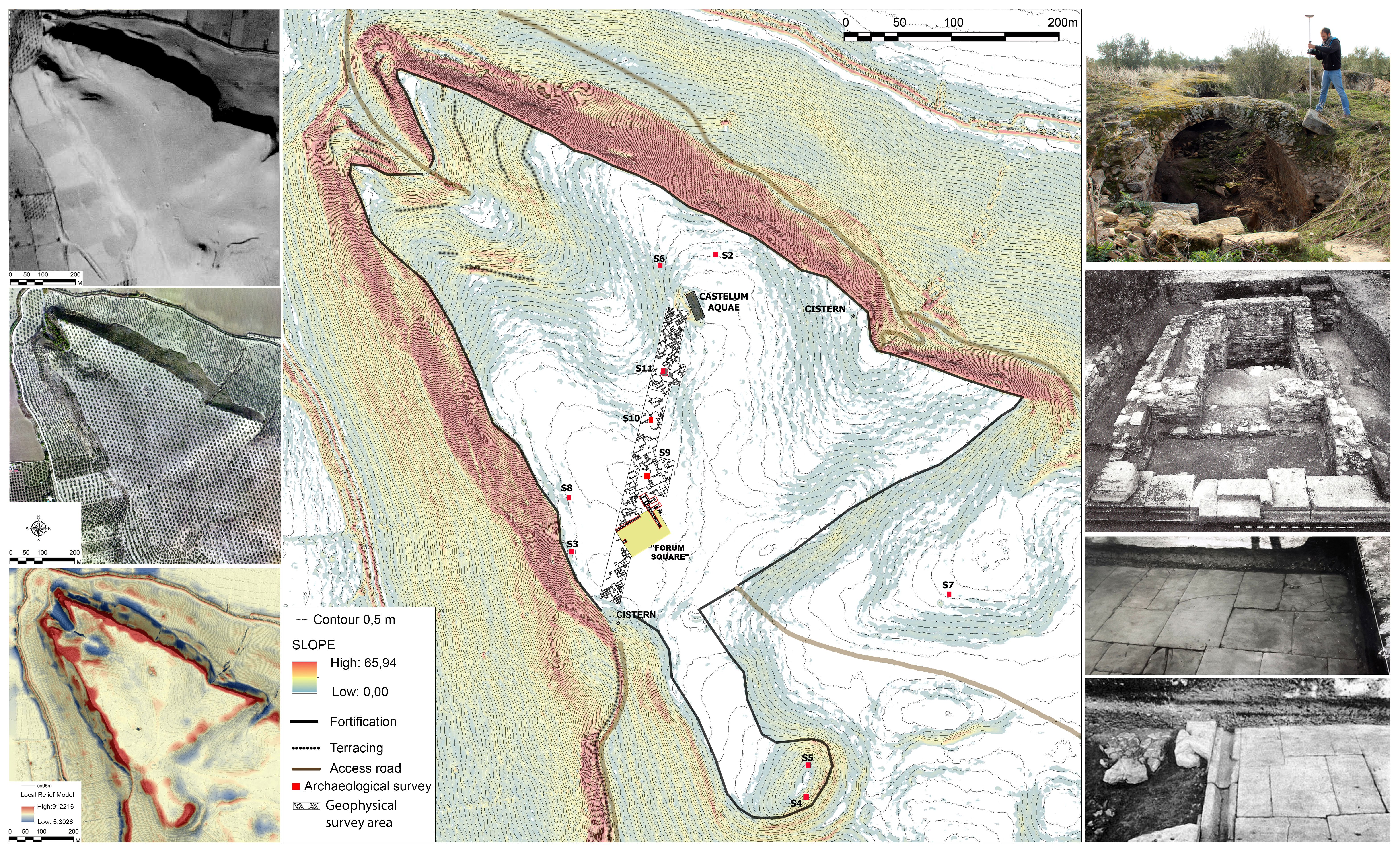
Focusing our attention on the Iberian site of Cerro de la Muela, the different studies of this location have revealed a walled perimeter demarcating an interior urban area of approximately 14 ha28 (fig. 2). These characteristics of a fortified hilltop place it in the category of an Iberian oppidum. This category, which alludes to a settlement pattern and, by extension, to a political instrument based primarily on population and resource concentration29, became the pre-eminent distinction of the Iberian territories, including that of Iliturgi. The size of this oppidum also makes it one of the largest oppida in the Upper Guadalquivir, along with Castulo (Linares, Jaén), Giribaile (Vilches, Jaén)30 and Los Turruñuelos-Baecula (Villacarrillo-Úbeda, Jaén)31.
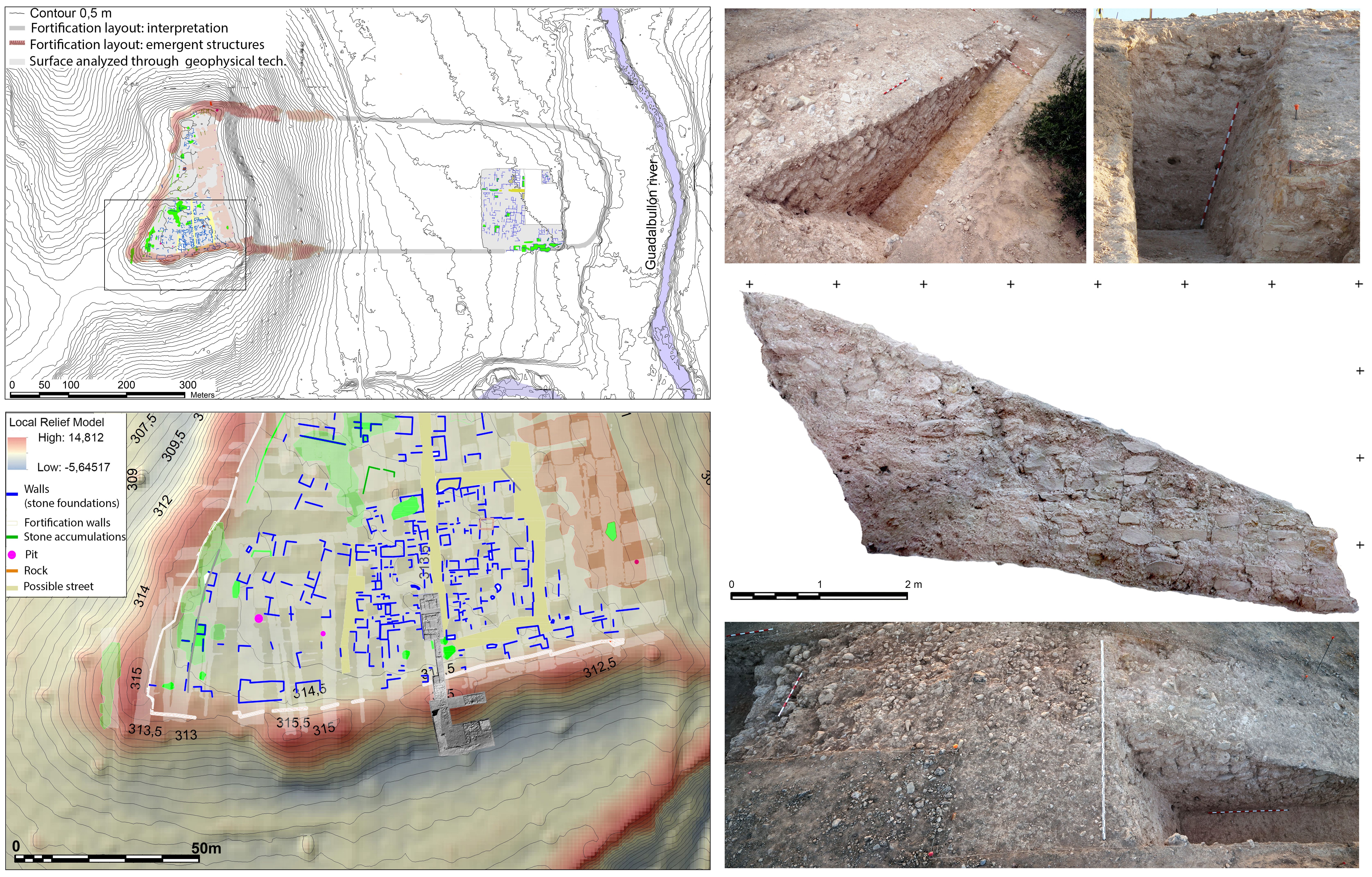
Modern road, industrial and residential development has significantly altered the original site occupied by this oppidum and its peri-urban territory. Nevertheless, the characteristics of the defensive system that would have delimited the Iberian urban area have been accurately documented at its western end. The microtopographic footprint defined by the defensive layout has made it possible to identify eleven emerging anomalies that show continuity from the linear layout of the fortification. Two of the eleven anomalies have been excavated, confirming that they were bastions adjoining the wall32. An acropolis area can be precisely defined inside the fortification, along with the fossilised footprint of the terracing system that would have connected it to the lower part of the oppidum, in a clear west-east orientation (fig. 2).
In terms of the urban planning and interior occupation, geophysical surveying at different points has revealed evidence of an urban framework characterised by a parallel and perpendicular layout of streets that would have bordered successive blocks of domestic structures33 (fig. 2). This rational, organic urban planning designed to follow the orientation of the fortification has been attested at other oppida in the vicinity of Iliturgi, including Puente Tablas34, highlighting the value placed on urban planning in the Iberian socioeconomic structure. The results obtained from the application of these non-invasive recording techniques have been ratified by the different archaeological surveys carried out at various points in the oppidum. Domestic units, the defensive wall and the two aforementioned bastions have been documented. The different contexts analysed show a sequence of occupation dated between the 6th and 3rd centuries B.C. The archaeological record shows that the oppidum came to a traumatic end when the fortification was levelled. The documented finds indicate that this would have taken place during a conflict episode related to the Second Punic War and, specifically, to Scipio the African’s siege of Iliturgi35.
As such, the data obtained at Cerro de la Muela has allowed us to assign a value to the decontextualised materials from the aforementioned necropolises. If we extend our focus of attention from the oppidum to the immediate territory, we observe a series of interesting characteristics, all linked to the spatial location of the different elements analysed. Thus, we observe that Los Chorrillos necropolis is located on the right bank of the Guadalbullón River, south of Cerro Maquiz. The chronology provided by the study of the finds shows that the cemetery would have been associated with the first occupation of Cerro Maquiz in the 7th century BC. The continuity of its use until the 1st century AD shows its role in the reconfiguration mechanisms of the tradition and memory of the territory and its Iberian identity, as we will see later. For its part, the funerary landscape of La Gravera is on the left bank of the Guadalbullón, north of Cerro de la Muela. Its chronology, framed between the 6th and the 3rd centuries BC, shows its direct connection with the Iberian oppidum and its end coincides with the traumatic event associated with the siege of the Iberian town36.
Both necropolises are indisputably associated with an essential element of Iberian culture: the river, together with the oppidum, was the mainstay of the social, political and cultural relations in the Iberian era37. The river (or rivers) played an essential role in Iliturgi. Its location, where the Guadalbullón flows into the Guadalquivir, and its proximity to the mouth of the Guadalimar, gave it a privileged position on the communications hub defined by those three rivers. Thus, from the 6th century BC, this oppidum occupied an optimum strategic position for exploiting the resources and controlling the territorial communications. In that context, the territory and oppidum of Iliturgi would have been key to the ordering of the main communication axes of the chronological period we are addressing in this study. The main artery in the Iberian period would have been the Via Heraklea or Hannibal’s Way. In the Roman period, as we will see, the route of the Via Augusta would become one of the most outstanding landmarks38.
The privileged location of Iliturgi was a catalyst for the development of this Iberian territory between the 6th and the 3rd centuries BC and would be of major strategic importance to the Roman and Carthaginian armies that sought to control the Upper Guadalquivir during the Second Punic War. Among other factors, the support of the oppidumfacilitated troop movements and the supply of resources. The stances adopted by Iliturgi during the conflict would become, in the year 206 BC, the casus belli of its siege.
Iliturgi delenda est… the siege and destruction of an Iberian oppidum and its territory
The archaeological excavations carried out on the oppidum acropolis show a restructuring of the defensive system at the end of the 3rd century BC, attesting an extension of the excavated bastions. Especially relevant is the reconfiguration of the bastion that protects one of the entrances to the town, possibly the weakest from a defensive point of view. In addition to the considerable size of this bastion, which exceeds those known to date in the Upper Guadalquivir, a moat of almost 3 metres deep was dug in front of it39.
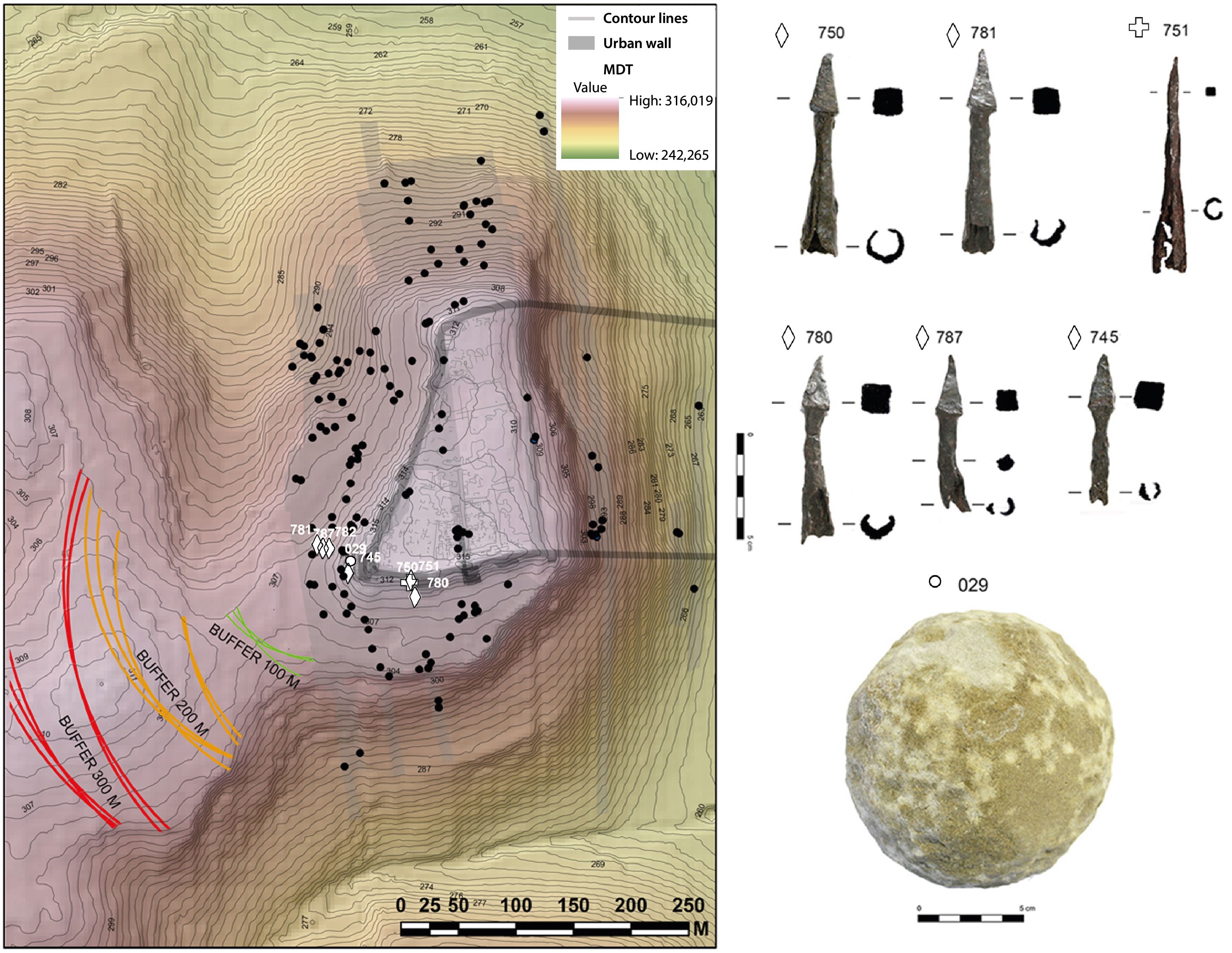
The stratigraphic contexts associated with this chronology correspond to a sudden and traumatic end in 206 BC, during the Second Punic War. This can be seen, for example, in the Hispano-Carthaginian coins documented in the fortification collapse levels. On the exterior, a rapid collapse of the elevation is identified next to the bastions. It is especially evident on the exterior of the large bastion, the collapse of which appears to have filled the moat with adobe and masonry40. It was in these levels that we documented a stone artillery projectile (lithobolos) that, together with a small metallic projectile (pila catapultaria) documented at ground level inside the fortification, point to a traumatic and violent end. This end is associated, as we will see, with a formal siege by assault and the scaling and taking of the walls41 (repentina oppugnatio)42.
These scarce but representative projectiles stratigraphically documented in the fortification collapse and abandonment levels are consistent with the surface metallic archaeological record. This was identified through a combined methodological strategy based on surface archaeological surveying using a metal detector and GPS georeferencing for the analysis of the spatial dispersion. This methodological strategy was designed and tested in other Second Punic War contexts in the Upper Guadalquivir, e.g. the Battle of Baecula (Santo Tomé, Jaén) (208 BC)43 or the attack on the oppidum of Puente Tablas44. It has been shown to be remarkably effective in the documentation and analysis of episodes characterised by a specific archaeological record, linked to very precise episodes45.
The finds associated with this conflict episode were located mainly outside the acropolis. The spatial dispersion of the materials shows a limited attack on the northern and southern slopes of the acropolis, right at its weakest point due to the oppidum gateway. The attack on the oppidum’s defensive structures thus required the use of specific weapons to facilitate the assault on the walls. These included projectiles (especially arrowheads) that account for 60% of the total record, compared to close combat weapons, such as the pilum, that represent only 8% of the total. The type of attack can be seen from the use of scorpio-type catapult projectiles, in addition to the ballista-type projectile (lithobolos) documented between the different silting levels of the moat. This type of projectile could only be launched using torsion (tormenta) artillery pieces (fig. 3). This is a tremendously important fact, since the classical texts that describe the taking of Qart-Hadasht by Scipio the African in 209 BC narrate in detail the capture of a large number of artillery machines (Liv. XXVI, 47), which from that moment on were available to the Roman army. The ascent to the fortification was harassed by the defenders with different degrees of intensity, as indicated by the varying concentrations of projectiles, mainly lead sling bullets and iron bipyramidal arrowheads found at the optimal range to have been fired from the fortification46.
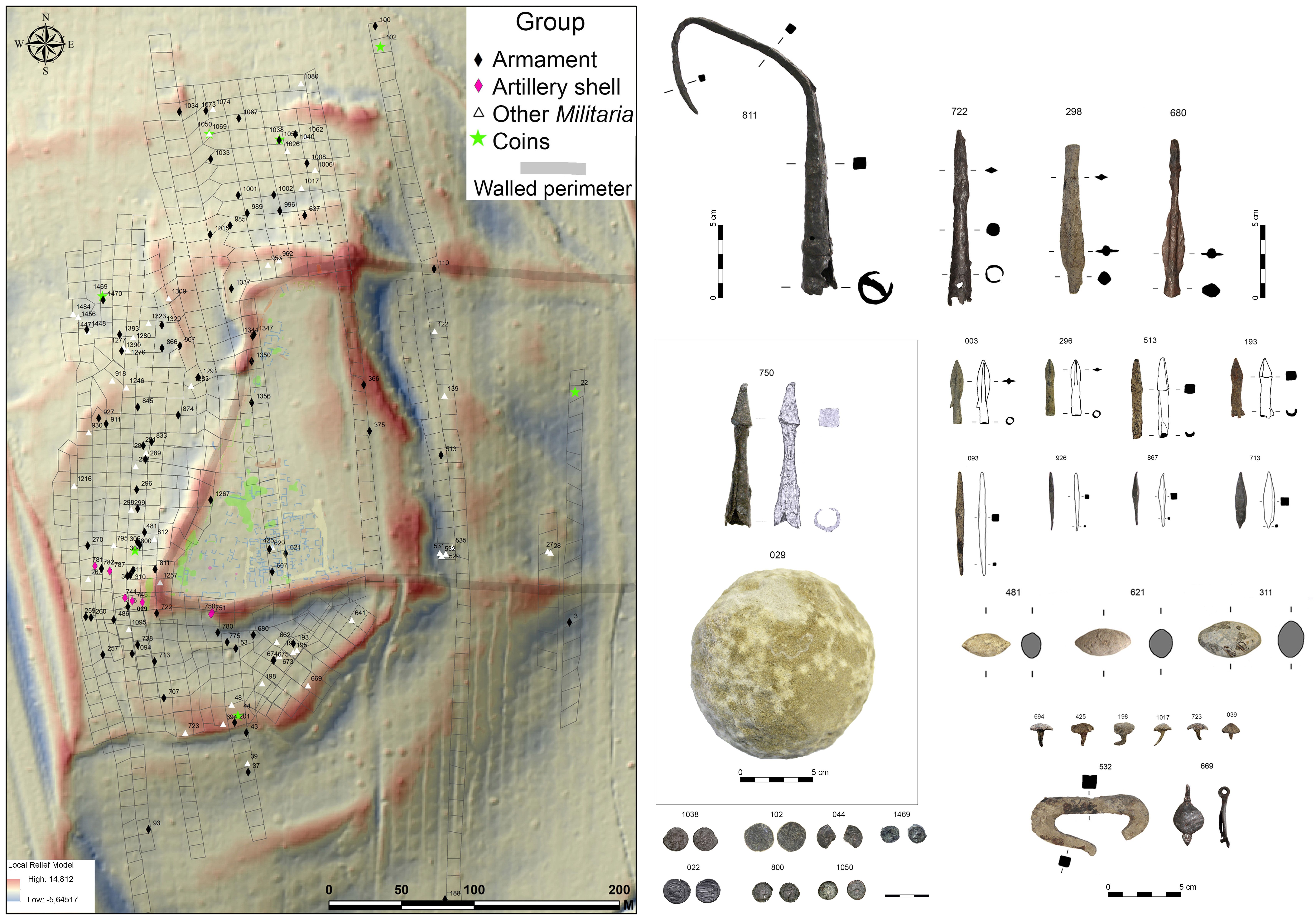
With regard to the spatial location of the heavy artillery, the restoration of the topography prior to the most recent alterations (in particular the construction of a dual carriageway), enabled this matter to be determined precisely. The Roman army placed its artillery pieces on a narrow hill in front of the acropolis and almost on the same level. This is demonstrated by the GIS analysis based on the identification of the point of impact of the projectiles launched with this type of machine, which is limited exclusively to this southwestern corner of the fortification47 (fig. 4).
According to the classical sources, the attack on the town was an act of revenge and retaliation by the Roman army after Iliturgi had denied aid to the Roman troops after the defeat at Ilorci in 212 BC, which led to the deaths of Publius Cornelius Scipio and Gnaeus Cornelius Scipio, father and uncle respectively of Publius Cornelius Scipio the African48. Scipio the African took revenge through this military action that is recorded thus in by Livy:
“…it became clear that the attack on the town was due to rage and hatred. No one thought of taking prisoners, no one thought of loot despite the fact that everything was offered for looting; they indiscriminately slashed the throats of those who bore weapons and those who were unarmed, women and men; in their angry cruelty they even killed young children. Then they set fire to the houses and destroyed what could not be consumed by the flames, they had such an urge to erase even the traces of the town and erase the memory of the place where their enemies resided” (Livy XXVIII 19 and 20).
All the elements discovered in the archaeological survey and, as we have already mentioned, the excavations, confirmed the demolition of the town walls, an action that not only implies the impossibility of defence, but also highlights the dismantling of one of the oppidum’s symbols of identity from the conceptual point of view. However, taking into account the partial nature of the record we currently have, we cannot state that the oppidum was completely abandoned after the attack. The presence of a series of data, both indirect, from archaeological surveys in the lower area of the town next to the river valley, and direct, the record associated with the last excavation campaign carried out in July 2021, reveal a possible residual continuity of the habitat. A life among ruins that illustrates the new period that began after the conflict, characterised by the social, cultural and identity survival of the local population, in the midst of a context that had completely broken with the previous security structures and uses, paradoxically mediating elements to ensure the maintenance of the new socioeconomic structure.
The pax romana. The disappearance of the oppidum and the construction of a new town and a new territory
A profound demographic and social crisis is attested after 206 BC. It involved a total dismantling of the power structures linked to the oppidum and, therefore, of the settlement and population concentration patterns that had characterised the previous period. So far, we have indirect indicators that tell us of a scattered occupation, possibly associated with the survivors of the conflict, but without a political entity or a socioeconomic structure that would have guaranteed their social development49. From the end of the 3rd century BC, there is an obscure period in the archaeological record, the form and structure of which is difficult to identify. This period appears to come to an end in the late 2nd century BC, at which time we see a series of political, social, ideological and religious transformations that gave rise to a complex process that would culminate in the definitive implementation of the Roman ways of life in the 1st century AD. This process, characterised by the phenomena of hybridisation, change and resistance detected in the material culture, is eloquently reflected in the foundation of the Iberian-Roman town of Cerro Maquiz, located on the right bank of the Guadalbullón River, opposite the ancient Iberian oppidum destroyed by Scipio the African’s troops. The new town, which preserved the place name of the Iberian habitat, was built, consciously or unconsciously, on the ruins of the 7th-century-BC proto-Iberian settlement50. According to the evidence from the excavations in the 1980s, it was founded at the end of the 2nd century BC51. Its location, on the right bank of the Guadalbullón River, just 500 m from Cerro de la Muela, respected the communication hub defined by the three rivers and, at the same time, became the direct interlocutor of the destroyed Iberian oppidum. In this way, a landscape of destruction and life was defined that sent an eloquent message to all those settlements that dared to challenge the power of Rome (fig. 5).
In the funerary area, despite the partial nature of a totally decontextualised record, a continuation in the use of Los Chorrillos necropolis can be observed. It became a fossilised landscape of memory that structured processes of continuity before and after the Roman conquest. A new necropolis is attested on the northern slope of Cerro Maquiz, near one of the entrances to the town. Closely linked to the Guadalquivir River, it represents a break, from the spatial point of view, with the axis defined by the Guadalbullón, a break that would be ratified from the change of era with the new Roman necropolis of Cortijo de Maquiz52. Associated with this necropolis are the so-called “Maquiz Bronzes”53, linked to one or more funerary chariots. These bronzes, along with other types of finds, show that the refoundation of Iliturgi, opposite the ruins of the ancient Iberian town, was made possible by, among other factors, establishing a framework of hybrid relationships in which Roman elements became increasingly frequent, but in which, without doubt, the Iberian component was essential. In this context, the position of the new power structures was based on Iberian tradition and memory, a cultural identity that went beyond the use of certain symbols and acquired its own personality during that period of change and fluctuation between the past and the present. The iconography of the bronzes reflects that moment, with special emphasis on the role of water and rivers in the construction of the mythology and history of Iliturgi54.
According to the finds deposited in the Ricardo Marsal Monzón Archaeological Collection of the Junta de Andalucía, a peri-urban sanctuary would have been located next to this necropolis. In it, of particular note is the deposition of stone votive offerings closely linked to late-period rituals55. The iconography of these votive repertoires reveals the complex context of hybridisation, integration and assimilation to which the foundation of the Iberian-Roman town of Cerro Maquiz would be associated between the late 2nd century and the last quarter of the 1st century BC56. The monumentalisation of Cerro Maquiz around elements of Iberian identity can also be seen in the area of the economy, with the issue of coinage from the Iliturgi mint. The proposed chronology for the beginning of the coinage, the 2nd century BC57, underlines the scenario of hybridisation we have been showing. In this context, the town’s elites chose, once again, an iconography that would have been easily recognised by the local population: the heroic figure on horseback. This type of representation, a symbol of prestige in Iberian society, became an icon of social representativeness in this context. A representativeness that is underlined by the inscription that maintains the toponym of the Iberian oppidum, but now reformulated in the Latin alphabet.
This period, characterised by a certain political entity of specific Iberian cultural elements, ended in the last third of the 1st century B.C. This is when, according to Pliny (HN III, 10), Iliturgi acquired a privileged status, that of Forum Iulium58, which would have been essential for the subsequent development of the Roman civitas. This moment clearly corresponds with the results of the excavations at Cerro Maquiz, where a small sacellum temple was documented59 in one of the corners of a large paved public square surrounded by monumental public buildings60 (fig. 5). The elements documented in this large square could associate it with the forum of the Roman town, which, as we have been able to define thanks to remote sensing and microtopographic analysis, covered an area of almost 17 ha61.
The architectural and structural characteristics of the town documented in these excavations show that it was fully integrated into the Roman social, political and religious structures. This new social organisation model coincides with the definitive abandonment of Los Chorrillos necropolis and the rise of new forms of funerary representation, as illustrated by the finds from the new necropolis on the Maquiz estate, which was established as a funerary road into the town from the Guadalquivir River from the turn of the era, following the Italic model62. The funerary epigraphy of this context alludes to the origo Iliturgitana63 and is further evidence of full adaptation to the Roman social and cultural forms in the Roman civitas of Iliturgi.
Along with all this, the situation of Iliturgi as a crossroads would be maintained in the administrative reform promoted by Augustus in the 1st century BC with the development of the Via Augusta in the vicinity. The archaeological identification of its layout, some 4 km northeast of Iliturgi, has allowed us to characterise this new road network, which runs to the north of the Via Heraklea used during the Iberian period. At the same time, as part of the research into the route of this road we have been able to archaeologically document the remains of an early Roman building complex conceived as a monumental landmark on the border between the provinces of Baetica and Tarraconensis. The excavation carried out in this context has made it possible to identify a monumental Augustan arch and altar, conceived as a gateway to Baetica province, of which only the foundations and few architectural elements remain, due to its intentional dismantling in Late Antiquity. The geophysical survey carried out in the surroundings of these elements revealed the existence, about 20 m below the arch and the altar and over the course of the Guadalquivir River, of a bridge and a possible service area. Archaeological surface surveying indicated a use that can be dated to between the 1st and 2nd centuries AD, which we interpret as consistent with this same process. This same interpretation could be made of a building documented by geophysical and archaeological surveying about 230 m west of the arch64.
The entire monumental complex of the Ianus Augustus, with its arch, altar, bridge and service buildings, would have been included in the power discourses associated with the so-called pax augustea, which would have been assumed and promulgated by Augustus in his role of maintaining peace within the Roman borders65. Its construction marked the end of a complex post-conflict process and is the most representative landmark of a period that began with the destruction of the Iberian oppidum and the dismantling of its traditional borders, a demographic and social crisis far removed from the intended image of peace and stability promulgated by Roman propaganda.
Conclusions. Iliturgi, the town of the three rivers
The methodological strategy defined in Iliturgi, indebted to the experience acquired in similar areas, such as Baeculaor Metauro, highlighted the need to integrate complementary analytical tools into archaeological research. The application of a comprehensive archaeological methodology that includes a thorough bibliographical and historiographical review, a critical analysis of classical sources, the application of photo-interpretation, digital terrain modelling, geophysical surveying and archaeological surveying and excavation, has proved its effectiveness in the analysis of complex historical processes. The data obtained, integrated and systematised through a geographic information system, shows more than the brief history, the event that determined the traumatic abandonment of Iliturgi at the end of the 3rd century BC as a result of the Second Punic War. Its application has allowed us to define precisely a) the settlement patterns that characterised this territory over a long period, from the 6th century BC to the 1st century AD; b) it has added to our knowledge of this conflict in the Upper Guadalquivir through the documentation of a conflict episode associated with a siege (with special interest in the artillery armament linked to the attack on a fortification); and c) it has allowed us to evaluate the impact of the war and the Roman conquest, characterised by the painful and complex period marked by the progressive disarticulation of the local Iberian ways of life within the Roman organisational structures.
The evolution of Iliturgi over time, as well as in space, evidences the key milestones in the conceptualisation of its landscape, with the identification of the elements that mark the transition between the Iberian and the Roman territory and identity. It was a traumatic and painful transition for the local population, not exempt from political use for the reconfiguration of the territory in a period as complex and delicate as the one defined after the war. Other elements, such as the rivers, remain undisturbed over time, silent narrators of the memory of this place. It is precisely its privileged strategic location, at the confluence of three rivers (Guadalbullón, Guadalimar and Guadalquivir), that has largely determined its historical evolution, its local development. The symbolism that two of these rivers (the Guadalbullón and the Guadalquivir) would come to represent over time would also be fundamental for the population concentration around the two sites of Iliturgi. The dialectic established between Cerro Maquiz and Cerro de la Muela, located on different sides of the Guadalimar River and barely 500 m apart, would be intense and marked by an alternative and, at the same time, complementary occupation (fig. 6).
Especially interesting, due to its complex nature and the context in which it is integrated, is the period between the end of the Iberian oppidum of Cerro de la Muela and the beginning of the Roman civitas of Cerro Maquiz. The demographic and social crisis that took place after the Second Punic War is evident in different elements of the archaeological record and is a significant example of the traumatic period associated with that moment. In this respect, the semantics that occur between the two spatial contexts, including funerary areas and other elements of representation, allow us to evaluate the impact of the landscape and its monumental landmarks on the configuration of the new socioeconomic model introduced by Rome. The narrative that emerges places us in a period defined by the hybridisation of its cultural traits, especially significant with regard to the reconfiguration of a profoundly damaged Iberian identity that had lost its reference contexts, its safety net, i.e. the oppidum (fig. 6).

Bibliography
- Arteaga, O., Blech, M. (1987a): “Excavaciones en el Cerro de Maquiz (Mengíbar, Jaén), Campaña de 1985”, Anuario Arqueológica de Andalucía 1985, II, 169-172.
- Arteaga, O., Blech, M. (1987b): “La romanización en las zonas de Porcuna y Mengíbar”, in: Los asentamientos ibéricos ante la romanización, Ministerio de Cultura, Madrid, 89-99.
- Arteaga, O., Blech, M. (1992): “Notas sobre las excavaciones arqueológicas sistemáticas en el yacimiento Cerro de Maquiz, en el término municipal de Mengíbar (Jaén)”, Anuario Arqueológico de Andalucía 1990, II, 230-233.
- Baena, L. (1982): “Esculturas romanas de Mengíbar”, Boletín del Seminario de Estudios de Arte y Arqueología, 48, 111-120.
- Bellón, J.P., Rueda, C., Osanna, M., Ruiz, A. (2013): “Numistro: de loco ad pugnam eligendo”, SIRIS, Studi e richerce della Scuola di Specializzazione in Beni Archaeologici di Matera, 13, 91-115.
- Bellón, J.P., Ruiz, A., Molinos, M., Rueda, C., Gómez, F. ed. (2015): La Segunda Guerra Púnica en la Península Ibérica. Baecula, Arqueología de una Batalla, Universidad de Jaén, Jaén.
- Bellón, J.P., Molinos, M., Rueda, C., Lechuga, M.A., Ruiz, A. (2017): “rome versus Carghae. The Second Punic War battlefield of Baecula and the siege of Iliturgi”, in: Fernández-Götz, M. and Roymans, N. ed.: Conflict Archaeology: materialities of collective violence in late Prehistoric and Early Historic Europe, EAA Monograph, New York.
- Bellón, J.P., Rueda, C., Lechuga, M.A., Ruiz, A., Molinos, M., Moreno, M.I. (2020): “Apology for a weapon of mass destruction: the use of the metal detector in archaeology. Research and management experiences in the Alto Guadalquivir”, Revista d´Arqueologia de Ponent, 30, 127-147.
- Bellón, J.P., Lechuga, M.A., Rueda, C., Moreno, M.I., Quesada, F., Molinos, M., Ruiz, A., García-Bellido, M.P.; Ortiz, I.; Vallés, J. (2021a): “De situ Iliturgi, análisis arqueológico de su asedio en el contexto de la Segunda Guerra Púnica”, Archivo Español de Arqueología, 94, 2-26.
- Bellón, J.P., Castuera, C., Rueda, C., Lechuga, M.A., Moreno, M.I., Gutiérrez, M. (2021b): “Construyen un desierto y lo llaman paz: la desaparición de los oppida en el Alto Guadalquivir”, in: La ciudad fortificada ibérica: el oppidum, Fundación Caja Rural de Jaén, Jaén, 111-124.
- Bellón, J.P., Lechuga, M.A., Moreno, M.I., Gutiérrez, M. (2021c): “Ianus Augustus. Caput Viae (Mengíbar, Spain). An interprovincial monumental border in Roman Hispania”, Journal of Roman Archaeology, 34, 3-29.
- Blanco, A., Lachica, G. (1960): “De situ Iliturgi”, Archivo Español de Arqueología, 33, 193-196.
- Blech, M. (2008): “El urbanismo ibérico en el sur peninsular bajo una perspectiva externa”, in: Adroher, A. y Blánquez, J. ed.: Primer Congreso Internacional de Arqueología Ibérica Bastetana, Universidad Autónoma de Madrid y Universidad de Granada, Granada, 93-104.
- Burgholzer, G. (1993): “Templo in antis de la Península Ibérica”, in: Dupré, X. ed.: La ciudad en el mundo romano: XIV Congreso Internacional de Arqueología, Consejo Superior de Investigaciones Científicas, Tarragona, 78-79.
- Castillo, C. (1983): “De epigrafía republicana hispano-romana”, in: Epigrafía hispánica de época romano-republicana, Institución Fernando el Católico, Zaragoza, 141-150.
- García-Bellido, M.P., Blázquez, C. (2001): Diccionarios de cecas y pueblos hispánicos, Consejo Superior de Investigaciones Científicas, Madrid.
- Gutiérrez, L.M. (2002): El oppidum de Giribaile, Servicio de Publicaciones de la Universidad de Jaén, Jaén.
- Jiménez, M. (2006): “Las inscripciones romanas de Mengíbar”, Boletín del Instituto de Estudios Giennenses, 193, 17-44.
- Lechuga, M.A., Molinos, M., Ruiz, A., Rueda, C., Bellón, J.P., Gómez F., Valderrama, J. (2019): “E la guerra giunse fin nelle nostre case. Tracce di un attacco alla porta nord dell’oppidum di Puente Tablas (Jaén)”, in: Vallori, B., Rueda, C. and Bellón, J.P. ed.: Accampamenti, guarnigioni e assedi durante la Seconda Guerra Punica e la conquista romana (secoli III-I a.C.): prospettive archeologiche, Edizioni Quasar, Roma, 43-57.
- Lechuga, M.A., Bellón, J.P., Rueda, C., Moreno, M.I., Castuera, C. (2020a): “El Proyecto Iliturgi: la historia de un territorio ibero del Alto Guadalquivir”, in: Carretero, A. and Papí, C. ed.: Actualidad de la Investigación Arqueológica en España I, Ministerio de Cultura y Deporte, Madrid, 121-137.
- Lechuga, M.A., Rueda, C., Bellón, J.P. (2020b): “Los Bronces de Maquiz. Nuevas propuestas para su contextualización dentro del proceso histórico de Iliturgi”, Complutum, 31(2), 305-324).
- Lechuga, M.A., Quesada, F., Bellón, J.P., Pérez, J.L. (2021): “Datos sobre el más antiguo empleo de artillería romana en Iberia: el asedio a Iliturgi (Mengíbar, Jaén) (206 a.n.e.)”, SPAL, 30.2, 158-188.
- Manso, E., Rodero, A. y Madrigal, A. (2000): “Materiales cerámicos procedentes de una necrópolis de Mengíbar (Jaén)”, Boletín del Museo Arqueológico Nacional, 18, 97-144.
- Novák, D. (2014): Local Relief Model (LRM) Toolbox for ArcGIS, Institute of Archaeology, Czech Academy of Science, Prague.
- Pastor, M., Carrasco, J. (1981): “Epigrafía y sociedad en la ciudad romana de Iliturgi”, in: Higuera, J. ed.: Epigrafía y sociedad en la ciudad romana de Iliturgi = Forum Iulium. Actas del I Congreso Andaluz de Estudios Clásicos, Jaén, 1981, Instituto de Estudios Giennenses, Jaén, 330-351.
- Poveda, A., Benedetti, L. (2007): “L´Iscrizione di ti. Sempronio Gracco da Iliturgi (CIL, II2, 7, 32): Aggiornamento archaeologico-epigrafico”, Epigraphica, Periodico Internazionale di Epigrafia, LXIX, 65-85.
- Quesada Sanz, F. (2007): “Asedio, sitio, asalto: aspectos prácticos de la poliorcética en la Iberia prerromana”, in: Berrocal, L. and Moret, P. ed.: Paisajes fortificados de la Edad del Hierro. Las murallas protohistóricas de la Meseta de la vertiente atlántica en su contexto europeo. Actas del Congreso, Real Academia de la Historia, Madrid, 75-98.
- Rísquez, C., Molinos, M. (2014): “Necrópolis ibéricas en el FARMM”, in: FARMM. Fondo Arqueológico Ricardo Marsal Monzón, Consejería de Educación, Cultura y Deporte de la Junta de Andalucía, Sevilla, 145-154.
- Rueda, C. (2011): Territorio, culto e iconografía en los santuarios iberos del Alto Guadalquivir (ss IV a.n.e.- I d.n.e.), Universidad de Jaén, Jaén.
- Rueda, C., González-Reyero, S. (2016): “La construcción social del cuerpo y las nuevas formas de identidad en los santuarios de época romano republicana en el sureste de la Península Ibérica”, in: Gamo, B. and Sanz, R. ed.: Actas de la I Reunión Científica de Arqueología Albacetense, Instituto de Estudios Albacetenses, Albacete, 569-594.
- Rueda, C., Bellón, J.P., Lechuga, M.A. (2022): “Recordar para (re)construir. Transformaciones y resiliencia en los paisajes religiosos de Iliturgi (Mengíbar, Jaén)”, in: Las sociedades íberas: Historia y Arqueología. I simposio de Historia en el territorio del Guadalteba, Ayuntamiento de Teba, Málaga, 61-85.
- Ruiz, A., Molinos, M. (1993): Los iberos. Análisis arqueológico de un proceso histórico, Editorial Crítica, Barcelona.
- Ruiz, A., Molinos, M. (2007): Iberos en Jaén, Universidad de Jaén, Jaén.
- Ruiz, A., Molinos, M., Gutiérrez, L.M., Bellón, J.P. (2001): “El modelo político del pago en el Alto Guadalquvir (s. IV-III a.n.e.), in: Territori polític i territori rural durantl’edat del Ferro a la Mediterránea Occidental. Actes de la Taula Rodona celebrada a Ullastret, Monografies d’ Ullastret 2, Girona, 11-22.
- Ruiz, A., Molinos, M., Rueda, C., Fernández, R. (2015): “El palacio y el urbanismo del oppidum de Puente Tablas”, in: Ruiz, A. and Molinos, M., ed.: Jaén, tierra ibera. 40 años de investigación y transferencia, Universidad de Jaén, Jaén, 107-118.
- Villar, F. (1654): Discurso apologético, en el cual se prueba que la población que antiguamente se llamaba Iliturgi o Forum Julium es hoy la ilustre ciudad de Andújar, Andújar.
- Weis, C. (2000): “Die Steindenkmäler der Sammlung ‘de la Chica’ in Mengíbar (Jaén) im Kontext der Sepulkralkunst des oberen Guadalquivirtales”, Madrider Mitteilungen, 41, 253-317.
- Wiegels, R. (1982): “Iliturgi und der dedutor Ti. Sempronius Gracchus”, Madrider Mitteilungen, 23, 152-221.
- Ximena Jurado, M. (1639): Antigüedades del reino de Jaén, Jaén.
Notes
- https://caai.ujaen.es/
- This study forms part of the Research Projects “Iliturgi GENS. Conflict, post-war and social changes in the landscape” (PID2020-118164GB-100), of the Spanish Ministry of Science and Innovation, and “Iliturgi. From Scipio to Augustus”, of the Ministry of Economic Transformation, Industry, Knowledge and Universities of the Junta de Andalucía (FEDER Funds), as well as the General Research Project “Iliturgi: conflict, territory and sacred landscapes” of the Ministry of Culture and Historical Heritage of the Junta de Andalucía. It has also had the support of the Ramón y Cajal subprogramme (RyC 2017-22122), financed by the Spanish Ministry of Science and Innovation (MCIN/AEI /10.13039/501100011033) and by the European Union (European Social Fund – ESF).
- Bellón et al. 2015.
- Bellón et al. 2013.
- Metauro Project. Institute of Cultural Heritage of Spain (IPCE). Foreign Excavations Programme (T002019N0000040044).
- Lechuga et al. 2019.
- Bellón et al. 2015; Bellón et al. 2017.
- Lechuga et al. 2020a; Rueda et al. 2022.
- Bellón et al. 2021a.
- Rueda et al. 2022.
- Bellón et al. 2021b.
- Bellón et al. 2021a.
- Ruiz & Molinos 1993, 2007.
- Arteaga & Blech 1987a, 1987b, 1992; Blech 2008.
- Lechuga et al. 2020a; Bellón et al. 2021b.
- Ximena Jurado 1639; Villar 1654.
- Blanco & Lachica 1960; Pastor & Carrasco 1981; Wiegels 1982; Castillo 1983; Jiménez 2006; Poveda & Benedetti 2007.
- Baena 1982; Weis 2000.
- Arteaga & Blech 1987a, 1987b, 1992.
- Blech 2008.
- Rísquez & Molinos 2014.
- Manso et al. 2000.
- Rueda et al. 2022.
- Ruiz & Molinos 1993, 2007; Ruiz et al. 2001.
- This method has been an essential tool for the reconstruction and visualization of ancient topography, with special interest in the study of the dynamic evolution of the Iberian and Roman landscape. We have focused the topographic analysis on the two locations of the urban fabric of Iliturgi (La Muela and Cerro Maquiz) and their dialectic relationship over time. In a practical way, Digital terrain modeling has provided the GIS base cartography necessary for the design, development and illustration of survey and excavation.
- Ruiz et al. 2015.
- Bellón et al. 2021a.
- Bellón et al. 2021a; Lechuga et al. 2020a.
- Ruiz & Molinos 1993, 2007.
- Gutiérrez 2002.
- Bellón et al. 2015.
- Bellón et al. 2021a; Lechuga et al. 2020a.
- Bellón et al. 2021a.
- Ruiz et al. 2015.
- Lechuga et al. 2020a; Bellón et al. 2021a.
- Rueda et al. 2022.
- Ruiz & Molinos 2007; Lechuga et al. 2020a; Rueda et al. 2022.
- Lechuga et al. 2020a; Bellón et al. 2021c.
- Bellón et al. 2021a.
- Bellón et al. 2021a.
- Quesada 2007, 77.
- Bellón et al. 2021a; Lechuga et al. 2020a.
- Bellón et al. 2015, 2017.
- Lechuga et al. 2019.
- Bellón et al. 2020.
- Bellón et al. 2021a, Lechuga et al. 2020a.
- Lechuga et al. 2021.
- The classical sources link Iliturgi with three Second Punic War conflict episodes. The first took place in 215 BC when the (pro-Roman) town was besieged by different Carthaginian armies, to finally be liberated by the Scipios, Publius and Gnaeus (Liv. XXIII 49, 5 to 12). The second episode was at Iliturgi in 214 BC. At that time the sources describe a renewed Carthaginian siege of the town where, according to Livy, a Roman garrison was stationed (Liv. XXIV 41, 8 to 11). The last episode is linked to the siege in 206 BC. This was the fatal blow for the oppidum of Iliturgi (Liv. XXVIII 19 and 20) and it was finally destroyed by the Roman army after more than ten years of almost continuous sieges (Bellón et al. 2021a; Lechuga et al. 2021).
- Bellón et al. 2021c.
- Blech 2008.
- Arteaga & Blech, 1992. The foundation could be connected with the epigraphic hapax of Tiberius Sempronius Gracchus (CIL II2, 7 32), through which, many decades later, the town sought to gain prestige and legitimise itself through the figure of the Roman praetor in Hispania.
- Rueda et al. 2022.
- Lechuga et al. 2020b.
- Lechuga et al. 2020b.
- Rueda & González Reyero 2016; Rueda 2011.
- Rueda et al. 2022.
- García y Bellido & Blázquez 2001.
- Poveda & Benedetti 2007.
- Burgholzer 1993.
- Arteaga & Blech 1993.
- Bellón et al. 2021c.
- Weiss 2000.
- CIL II2/7, 32 = CIL I, 2927 = CILA III.I, 225; CIL II2/7, 36 = CILA III.I, 233; CIL II2/7, 39 = CILA III.I, 2,31. Jiménez 2006; Pastor & Carrasco 1981.
- Bellón et al. 2021c.
- Bellón et al. 2021c.