


Introduction
The current world is shaped by territoriality. Relevant recent examples of territoriality-based strife include conflicts such as the Ukraine/Russia/Crimea conflict, the Israel/Palestine dispute over settlements and Trump’s wall at the US-Mexico border. Territorial wars of the twentieth century are no less notable. However, conflicts are a symptom of territoriality and a small part of the phenomenon of territoriality rather than an essential component. The core of territoriality is formed by territorial administration. We can hardly imagine a world without territoriality. Even in a globalized world, transnational enterprises benefit from a strategic use of different laws in different territories and hence take advantage of territoriality. These examples indicate that it is the dominant principle of spatial organization in the current world.
Considering the dominance of territoriality during the last millennium, it seems natural to assume that territoriality shaped spatial organization in prehistoric times too. But what exactly is territoriality? Is it a political division of space? Though political territories spring to mind, the term “territory” actually has an abstract and formal definition: territories are areas with sharp borders assigned exclusively to a certain unit. Territoriality is hence the dominance of territorial structures among the various structures used for spatial organization. Other concepts of spatial organization are also possible. Mobile communities (e.g. nomads) do not have precisely defined territories. Communities where social organization dominates the spatial structure (e.g. the Germanic Gefolgschaftswesen, i.e. followers or vassals) also need no fixed territories. Small groups in sparsely populated areas have no need for fixed borders. Overlapping fields of influence (e.g. economic market areas) do not comply with the concept of territories.
Territoriality is a very effective way of organizing space. It is not only a spatial aspect or just a spatial representation of social organization. Territoriality, with its sharp boundaries, defines and regulates social actions and hence contributes to the organization of society (Paasi 2003). Territoriality also has some peculiar effects. The so-called phenomenon of “purification of space” (Sibley 1988) describes a homogenization of spaces resulting in reduced complexity. Reduced complexity is certainly advantageous since social, economic, and political spaces formed of many different elements and interrelationships are difficult to understand and even more difficult to predict. Although reducing complexity is an advantage, territories produce some rather problematic effects. The purification of space results in a drawback known as the “territorial trap” (Agnew 1994). While territories lead to a better understanding of spatial relationships, they also allow the space inside the territories to appear homogeneous, even in cases with arbitrary borders. Territories hence have a large influence on the perception of space. Territories are a means to establish a certain perception of space, and hence to legitimate certain socio-spatial organizations. Here, the tight interrelationship of space and social behaviour takes full effect.
Territoriality is related to centrality (Nakoinz 2009, 2012, 2019, 2020; Fig. 1). According to Christaller (1933), centrality is the relative surplus of meaning a place possesses compared to its complementary area. The complementary area, a kind of hinterland, is an area with distinct borders related to the centre and hence is nothing but a territory. The idea is that the settlement system is very efficient if all sites in the complementary area are supplied with commodities and services from centres which are closer than other centres belonging to other complementary areas. The spatial configurations of centres and their hierarchy is determined by the spatial range of goods and services. Territories play a major role in the spatial configuration of central places. They define the degree of efficiency of transport in the system. Centrality is a principle of spatial organization, which attempts to optimize the structure by minimizing the effort of transportation and similar factors. Centrality is frequently used for spatial organization but cannot be assumed to be universally valid. While in urban planning and other future-oriented activities central place theory might be helpful as a guiding theory, in empirical research centrality is just a hypothesis and thus must be tested. The reconstruction of territories of central places is part of this process.

In addition, another type of centrality must be considered. Unlike centrality in central place theory, network centrality (Freeman 1977) does not require territories and is focused on the connections between related places without distance restrictions. Betweenness, one example of a centrality measure, considers connections between places which are controlled at one specific place. While Christaller’s centrality concentrates on the efficiency of transport and similar factors, network centrality considers the efficiency of control and influence. In geography, a paradigm shift from Christaller’s centrality to network approaches has been proposed. This works in regional planning but not in empirical research analysing the past. We just cannot dictate which organizational structure people in the past applied. However, we can say which structure would have been useful and we can ask which was actually applied. Again, empirical research needs to be tested. While one organizational structure may be dominant, both are complementary in a certain sense. Christaller’s centrality is not a useful approach for long-distance trade and Christaller (1933) never assumed it to be so. On the other hand, the restrictions that are part of Christaller’s concept can be useful for understanding the organization of local supplies and political structures.
Having explained some basics of centrality, we can state that territories are connected to Christaller’s principle of spatial organization and not to network approaches. Hence, territories can help in distinguishing the dominance of one of the concepts; if we cannot find territories corresponding with centres, Christaller’s centrality seems to play a minor role. Important finds such as indicators of central functions from the centres do not help to differentiate between Christaller’s centrality and network centrality. They are hardly even useful for establishing centrality since centrality is defined as the relative meaning of a place. A very large settlement can possess no centrality if the number of central functions it would provide if it acted as a centre is less than would be predicted by its size. In fact, it is the specific relation of the centre to the other places that establishes centrality and not certain features of the central place.
History of research
In Iron Age archaeology, territoriality has long been an issue. Studies examining the territories of Celtic tribes in the Late Iron Age are one example. While the stimulus of written sources does not exist for archaeologists focusing on the Early Iron Age, some outstanding places, namely princely seats, have posed the question of territoriality. Wolfgang Kimmig, who introduced the concept of princely seats, rather reluctantly considers:
… whether the concentration of rich noble burials is connected with territories. … But all of this is pure speculation …
(Kimmig 1969, 108, translated by the author)
Other authors have been more certain about territories. Hartwig Zürn (1970) assumes that the territory of the Heuneburg corresponds to the Alb-Hegau ceramic distribution. Frankenstein & Rowlands (1978) also presuppose certain territories. The concept of concentration of power (Sievers 1982; Biel 1987; Pare 1989), which claims that during Hallstatt D1 and D2 the elites – indicated by daggers, wagons and hillforts –, begin to concentrate or are concentrating, also implies growing territories. Chaume (2001) developed a triple ring model, with a radius of 50 km for the entire territory, a 25 km radius for the primary economic area, and a 10 km radius for the area in which the elite is concentrated.
Various attempts have been made to estimate the size of the territories empirically. One example is the princely seat of the Glauberg (Herrmann 2005). Pollen from honey found in a bronze jug in the princely barrow to the south of the defended hilltop site was used as an indicator of dependent places. The theory is that the honey in the jug was contributed by all dependent communities on the occasion of the burial. Since the areas where honey was produced do not have any outstanding sites, they must be subordinate to the Glauberg elites and hence be inside the Glauberg territory. The problem with this approach is that a ranking of sites does not imply that the lower-ranked sites are subordinate to the highest ranked one. Trade in honey is also possible and even contributions from independent trading partners to the burial could be an explanation of the pollen.
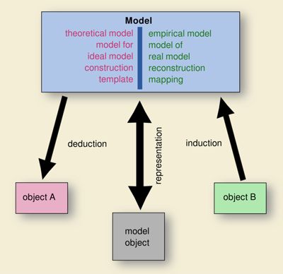
Heinrich Härke (1979) applied a modelling approach to the problem of territories of the princely seats (Fig. 2). He used Thiessen polygons, also known as Voronoi graphs, for estimating territorial limits. The border is drawn where the distance to two centres is equal. We must be aware that Thiessen polygons are theoretical models which do not tell us anything about the reality in the past. Thiessen polygons can be used for defining where the optimal location for a border is, but not where the borders actually were. It is always necessary to validate the theoretical model by comparison with an empirical model (Fig. 3; Nakoinz & Knitter 2016, fig. 2.5). If a theoretical model fits an empirical one, it is possible to transfer the knowledge about the principles used in constructing the model from the theoretical model to the empirical model. In this case, new knowledge emerges, and the empirical model gains additional meaning (and vice versa). Härke (1983) was aware of this and tried to verify his model using the location of burial mounds near the supposed territorial borders. In my opinion, this is not very convincing since the dense distribution of burial mounds in Baden-Württemberg allows for several different borders. A more persuasive approach would be to generate a territorial model based on only the burial mounds first, and then compare it with the Thiessen polygons.

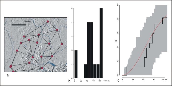
It is clearly necessary to involve more empirical data. This is what Patrice Brun (1988) tried to do in his attempt at establishing the general size of territories using the distances between the neighbourhoods of princely seats. Using a histogram, Brun found that certain distances were preferred and hence that the princely seats were distributed regularly, their territories were of equal size and thus limited the extent of the neighbouring territories. In the 1980s, more advanced methods of testing distributions were developed, but were only available to a small community of statisticians working on spatial problems. Today, methods such as G-function or Ripley’s K-function are available in many software packages. We can apply the G-function, which draws a cumulative function of the nearest neighbourhood distances, and compare it with simulations of random points. In the case of the princely seats (Fig. 4; Nakoinz 2013a, 45-76), the empirical curve is inside the grey area which indicates the results of the simulations, meaning that a completely random process could produce a similar distribution. The idea of regularly distributed princely seats with territories of equal size is not supported by the new analysis.
Patrice Brun’s (1988) next step after attempting to verify the Thiessen polygon approach was to look at the material culture inside the assumed territories. He found significant differences. He used the relative quantities of certain types of fibulae (a total of 403 fibulae) to show different cultural traditions. Without the confirmation of the Thiessen polygon approach, material culture would have been used first to establish the existence of territories.
The reconstruction of Iron Age territories has been rather difficult and has suffered from several problems. First, unfounded assumptions such as hierarchies, tessellation (Thiessen polygons), and the use of just a few diagnostic types for cultural analysis must be mentioned. Second, some unsuitable methods have been used, such as theoretical models without proper validation, histograms instead of modern Complete Spatial Randomness (CSR) tests and comparing regions instead of validating borders. A solution must include minimal assumptions, adequate methods, and extensive data.
Marked borders
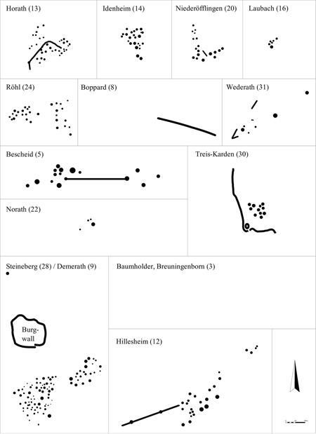
Since borders are a significant part of territories, they might be useful for detecting and identifying territories. From the Roman Iron Age and medieval times, we know about fortified and marked borders. Searching for linear fortifications could be a first step for identifying Iron Age territories. In Baden-Württemberg, no such linear fortifications are known. Further west, linear dykes or ditches are known from burial ground contexts (Nakoinz 2003; Fig. 5). They are located just inside the cemeteries, connecting burial mounds, separating areas of the burial grounds or forming partial limits. In general, there are no indications that allow for the interpretation of these ditches as territorial markers. Excavated ditches (e.g. at Bescheid: Haffner 1992, 51) rather indicate a use within cultic activities. The ditch in Bescheid connects two barrows, one containing a chariot grave; the ditch is interpreted as a ditch for processions.
Further north, in Denmark, another type of linear fortification has been found in the recent decade (Schlosser-Mauritsen 2010; Eriksen & Rindel 2018). The so-called hulbælter or pit zone fortifications do not have walls (Fig. 6). They consist of small pits with wooden stakes in-between and it can be hypothesized that they were covered with brambles. This type of fortification is very efficient since it requires much effort to cross and little effort to build. Pit zone fortifications can be found as enclosures and as linear fortifications. Some fortified lines can be traced for several kilometres and hence suggest a kind of border fortification that can be interpreted as an indicator of territoriality. Actual fortifications in pre-Roman Denmark were considered rare (Martens 2007; Nakoinz et al. 2017), with just a few walled fortifications known, including those at Borremose and Petersborg. Pit zones, usually found by aerial photography, make up the vast majority of fortifications of this time in Denmark, concentrated in a certain area in northern Jutland. Further north, in the Limfjord area, tell-like settlements are another unusual phenomenon. Both phenomena could be ascribed to a decrease in soil quality in an area that has been densely populated since the Bronze Age. Territoriality in the north occurs in the context of a much lower social complexity than that of the Hallstatt culture. Nonetheless, this detour through pre-Roman Denmark shows that territoriality can be documented by archaeological sources.

Interaction space
In the case of south-western Germany, Brun’s approach of using material culture can be adapted to indicate cultural areas (Nakoinz 2013a). The idea is that territories, at least if they are the basis of power and wealth of certain centres, produce considerable evidence of internal interaction and hence can be detected as interaction spaces or cultural spaces according to our notion of culture.
Interaction produces similarities and thus similarities can be used as indicators of interaction. Of course, caution is required since similarities can also be the result of convergence or can occur by chance. The more similarities are present, the higher the likelihood of interaction. This has some methodological implications. While traditionally diagnostic types or cultural markers have been applied to the problem, we need to use all available information. According to our considerations, given that interaction is likely to increase with similarities, to focus on just one or a few diagnostic types would be insufficient. In addition, we should try to ascertain the significance of the diagnostic types. To analyse cultural areas from diagnostic types that are supposed to (re)construct these entities is just not possible. The solution is to use all available types of artefacts and structures rather than solely diagnostic types. For entities which have been characterized by all available information, the relative number of observations of different types are compiled in a vector of interval-scaled values. This compilation is called a Typenspektrum in German, or “spectrum of types,” in order to distinguish it and its specific meaning from the more general term “type spectrum” referring to a range of types.
Using all the available information does not necessarily mean that all of it must be used at once. It is also possible, and often even useful, to define different groups of types representing different time slices, different parts of society, and different other entities. Comparing the results for different groups of types can be very instructive and reveals something of the organization of interaction structures.
The Typenspektren are independent from the absolute quantity of objects and observations since the sum of the vector is always one. This ensures that the comparison of different entities focuses on the characterization of the archaeological material rather than on the amount. This property is essential for the next step, the calculation of a cultural distance between two entities. Cultural distances are a measure of similarity and hence an inverse proxy of interaction. Cultural distances are the Euclidean distance of the Typenspektren of two entities. The entities can be defined in different ways. We could use sites but the different samples sizes of sites with just a few observations and sites with hundreds and even thousands of observations would produce biased cultural distances. Using all information inside a certain area would reduce this problem but decrease the spatial resolution of the analysis. Instead, we use a kind of fuzzy area. First, the kernel density is calculated for all types and then these different density maps are sampled at regularly spaced points. This approach ensures comparable values in both areas with a high density of observations and those with a low-density. In the high observation density areas this approach preserves a high spatial resolution as long as the kernel is not too broad. In low-density observation areas a wider area affects the Typenspektrum. This must be considered in the interpretation to avoid defining interaction spaces based on methodological artefacts such as similarities in low observation density areas.
The cultural distances can be used directly to investigate interaction intensity. Distance diagrams (Nakoinz 2013b) are an approach to understand interaction structures. Cultural distances can also be used to reconstruct interaction areas by grouping similar Typenspektren and hence similar sample points, sites, or areas. The grouping approach suits our objective best and thus we apply a cluster analysis on the data using cultural distances. We are deliberately do not use principal component analysis (PCA) for data preparation. If fewer latent variables are assumed than original variables are available, then a PCA reduces the number of variables by cutting some artificial and not significant variables according to their low variance. The original variables are mapped to new ones, which are as independent as possible from each other and are ordered by the variance of the original variables contributing to them. The latter are correlated when there is a difference in the eigenvalues because they contribute to more than one latent variable. Using the original variables would produce a biased result, because the variables weight the information in a different way than the latent variables would. In our analysis, we assume a certain correlation of the types resulting in a certain weighting of information. There are no latent variables, the weighting is intentional and does not produce a biased result. To clarify, some explanation of theoretical foundations is necessary. According to Hansen (2003, 39), culture is defined as a group of individuals (“collective”) with shared ideas and behaviour (“standardizations”). The similarities/standardizations are caused by interaction. Each artefact or structure type represents a standardization and not a latent variable such as interaction. Cultural distance, which is a transformation of the original data, is a proxy of interaction. Therefore, it is obvious that data preparation and data reduction using PCA would not agree with our theory.
The first step of the analysis consists of a hierarchical cluster analysis, which provides us with many possible clusters and even with a hierarchical structure of different clusters (Fig. 7). All clusters have to go through two validation processes. First, an internal validation tests whether there is good reason to believe that a cluster represents a clear structure inherent in the data. If, for instance, two clusters are not clearly separated, they are assumed to be invalid and are excluded from the next steps. Second, an external validation uses the correlation of a cluster with a variable not used in the cluster analysis to test how likely it is that the cluster represents a structure in the real world. We use geographical coordinates for external validation, which means that spatially dispersed clusters are excluded. As mentioned, the density of observations must be considered for the external validation in order to avoid artificial spatial clusters.

The primary cluster analysis results in different hierarchical structures of different groups of types, with each structure being composed of many groups. Although validation reduces the number of clusters, there still remain many valid clusters for more than 200 different groups of types. While it is possible to compare all these clusters pairwise, a secondary cluster analysis is required for recovering the dominant structures within the primary cluster results. Since we are not interested in the relationship between the primary clusters but rather in the dominant spatial structures, a hierarchical cluster analysis is not necessary. The secondary cluster analysis clusters the primary clusters according to their spatial extent. Clusters of similar size that are located in the same area are grouped together. Since it is possible for each sample point to determine the number of clusters covering a specific location, a sort of degree of membership for each location/sample point can be calculated. This results in a realistic border mapping, which can be fuzzy or sharp according to the data. Furthermore, the secondary clusters can overlap and represent completely different or independent structures. Although we use the notion of culture for our results, the formal properties of the interaction spaces recovered in this analysis do not meet those of traditional archaeological cultures. Our modified theory and methodology ensure coherent research and avoids many of the pitfalls and criticized aspects of the traditional approaches. The interpretation of cultures as interacting groups rather than the traditional ethnic interpretation constitutes a significant change. It implies that sharply defined cultural areas are not presumed but are hypothesized and then tested. The interpretation of the interaction areas is not the purpose of this analysis but is a step which requires additional considerations and assumptions. We shall consider these issues after presenting the results of our analysis.
First, we shall briefly present the results of our proposed method on material from the Hunsrück-Eifel culture (HEK). Although the analysis used a previous and simpler version of the algorithm described (Nakoinz 2005), the results are useful for comparison with the new analysis of material from Baden-Württemberg. The main differences between the versions of the two algorithms are that the former algorithm uses areas with sharp borders for compiling the Typenspektren and lacks a secondary cluster analysis due to the insufficient number of primary clusters. Nevertheless, a re-analysis of the HEK material using an early variant of the new algorithm described above confirmed the original results, showing that the early version is also replicable (Nakoinz 2013a, 29-30). For the Hunsrück-Eifel culture, the research objective was to test whether it can be considered to be an independent culture (interaction space) or a transition zone. This analysis uses just three groups: jewellery/dress accessories (Fig. 8), ceramics, and weapons. While the internal structure of the groups of the different Typenspektren is very heterogeneous, the boundaries of the different clusters, which correlate with the traditional limits of the HEK, are almost identical in spatial extent. This suggests that the border was recognized by different parts of society and acted as an interaction restraint, while an increased intensity of interaction inside the HEK cluster justifies speaking of a HEK culture, i.e. a HEK interaction space.
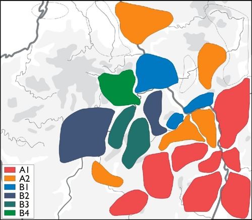
For the analysis of Baden-Württemberg, the new algorithm (Nakoinz 2013a, 2014, 2016, 2018) was used and applied to five times the number of finds (68,552). This larger volume of the main source of observations meant that it was possible to use more groups of types without having insignificantly small group sample sizes. While the HEK analysis focused on the Hallstatt period, the new analysis of Baden-Württemberg also included Early La Tène material. The extended period and the consideration of different typological levels led to 225 different groups of types for this analysis. Unfortunately, the analysis was restricted to the territory of Baden-Württemberg, resulting in some uncertainties near the borders of the state. In particular, in the Rhine valley, the vicinity of Ipf and the border to Hesse cause edge effects in the analysis. While the results of the primary analysis fill more than 500 pages and can be accessed online only (Nakoinz 2010), the results of the secondary cluster analysis can be presented on one figure comprised of six maps illustrating six different secondary clusters (Fig. 9; Nakoinz 2013a, fig. 6.7). All clusters have fuzzy but sufficiently defined borders. The first three show rather compact areas called zones. Although they overlap to a certain degree, they appear mainly disjunct. The same is true for the three corridors, which have an elongated shape and are connected to the main river systems. Corridors and zones overlap since each of the three corridors and the three zones fill the whole area analysed. Thus, we contend that these categories represent completely different types of entities. While the corridors represent traffic-based exchange networks, the zones represent areas of traditional regional interaction.

Comparing the HEK and the Baden-Württemberg results, we find that the corresponding primary clusters of both case studies form a kind of dominant interaction space. In the HEK, this area has quite well-defined borders. In the case of Baden-Württemberg, the borders are fuzzy and the resulting structures are latent, overlain by many interaction areas of different size and location. The borders seem to have a completely different character. While the HEK borders were respected by most people, the recognized borders (taking into account the edge effects) in Baden-Württemberg were very persistent since they can be detected in all phases, only in a less pronounced manner. It seems clear that in the Hallstatt culture most social groups were able to establish interaction areas of their own; spatial structures indicating the presence of a strong power regulating interaction and movement were less distinctive.
The function of princely seats
The Baden-Württemberg case study has some implications for the interpretation of the princely seats. An important observation is that the zones and the princely seats do not correspond. The princely seats tend to be located at the border between zones and hence they cannot be the centres of the zones. Or, in other words, the zones cannot be the territories of the princely seats. The territories might also be smaller than about 20 or 30 km in diameter, which is the minimum size detectable by this method. In any case, there is no such strong centre-hinterland connection as would be required to explain the wealth of the centres on the basis of territorial power. An interpretation of the princely seats mainly as Christaller-type centres is thus obsolete.
The concept of network centrality provides an interpretation which agrees with the observations made. Network centrality does not call for territories beyond the area required to maintain carrying capacity. Network centrality is based on the control of interaction passing through a site and not on focusing the interactions of a certain territory on one centre. The location of such centres at the borders suggests an interpretation of the princely seats as gateways. Gateways are a specific type of network centre controlling the exchange between two areas. They do not control a territory but regulate access to an area, and they are usually part of a supra-regional exchange network. Interpreting princely seats as gateways suggests that the region containing princely seats and graves was a contact zone. The idea of a contact zone indicated by rich graves and exceptional settlements moving northwards was proposed by Brun (1988). Dirk Krausse (2008) thought of this contact zone in terms of economic conjuncture. In a certain sense, a contact zone corresponds with Kossack’s (1974) periphery. According to Kossack, exceptionally rich graves are found not in the political centre but at the periphery of civilizations, where local elites seek to connect to the ideas of the (more centrally located) elites of the dominating civilization. The local elites express their ambitions in times of cultural change through prestigious graves. Our interpretation is different. We agree with the idea of prestigious sites at the periphery, but not with the exclusive focus on the centre of the civilization or, in our case, on the centre of a certain organizational structure. The prestigious sites are gateways at the periphery and give access to and from an external area organized according to different rules. The function as a gateway is indicated by the presence of prestige finds, i.e. expressions of the wealth of people who managed the contacts across the borders. From our point of view, prestige is not just the result of power and wealth but it is also required for making a fortune by organizing exchange. The presence of prestige objects advertises the gateway function. The people organizing the exchange benefit from exploiting different organizational structures. After the passage of some time, the areas on either side of the border adapt to each other or the weaker entity adapts to the dominant one. Then the contact zone moves.
In this scenario, the prince or princes of the Heuneburg were not territorial rulers accumulating wealth by redistributing regional commodities or demanding tribute from subordinates in their territory; rather, they were entrepreneurs organizing cross-border exchange, acting in a European network and maintaining a kind of principal office advertised by prestigious goods. They resemble entrepreneurs such as the founder of Amazon, Jeff Bezos, rather than regional administrators. They are economic global players rather than regional kings.
If we consider the concept of concentration of power from this point of view, there is a concentration of economic power instead of political power. In a political sense, the elites of the princely seats are peers of the traditional elites who ruled over (presumably) small territories and held moderate wealth. Prestige must have become less important for the traditional elites since they would never have been able to compete with the new economic elites’ expressions of extraordinary wealth. The traditional elites, possibly of Bronze Age origin, showed their social and political ambitions (as indicated by prestige) during Hallstatt C after the breakdown of the European Bronze Age. Then, they became rather invisible again, leaving the means of communicating economic function through prestige to their peers who lived in strategic positions and established the business of managing exchange.
The prospering business at the princely seats led to agglomerations with a proto-urban character. While we agree with Brun and Chaume’s (2013) idea of an unfinished urbanization, the hypothetical interpretation presented here does not involve the process of state formation and political development as connected to the development of the urban phenomenon in the Mediterranean. The agglomerations were caused by economic success and people were attracted by prestige. The process of urbanization halted with the abandonment of the gateways, which lost their function with the shift of the contact zone.
Conclusion
Our study reveals, quite surprisingly, that territoriality did not play a major role in the Early Iron Age in south-western Germany, while it operated in Jutland, at least some centuries later, during the pre-Roman Iron Age. Although, the differences between the two regions are not as marked as was thought some decades ago – for instance, Martens (2009) suggests that society in Jutland seems to have a degree of social hierarchization – the differences are distinct enough. In pre-Roman Iron Age Jutland, society did not have a pronounced hierarchy and had no exceptional central sites such as the Heuneburg. This leads to the conclusion that territoriality is not correlated with social hierarchies or with centrality in general. Territoriality is neither a requirement, nor the result, of social and political hierarchization and centralization as it has become in more recent times. Territoriality is rather a strategy used under certain conditions to solve certain problems. To understand which conditions and which problems these are, we must look into the nature of territoriality. According to our formal definition, as well as to other definitions of territories, territories are certain pieces of land. People use the land, people are certainly an important factor, but they are not involved in the concept of territoriality. It is land that is delimited by other stretches of land and assigned to certain entities. It is at this stage that people become instrumental; the land has a certain value to the people, who try to own the land and to secure this property against others. But why would land be so valuable? It is not the size and probably not the people living on the land. Were it the people, we would assume a concept of territoriality to be the cause of the emergence of territoriality. People belonging to a patch of land is certainly a kind of territoriality, but it cannot define the value of the land, the characteristic which leads to the development of territoriality. This reasoning would be a circular argument. Land use and natural resources are what makes land valuable in the first place. The value depends on limits. How much land, and in particular land which serves certain needs, is available? If there is no shortage of land it is not necessary for people to secure certain stretches of it and develop territoriality. This limitation depends on the quality of land as well as on the density of its population. In northern
Jutland, the nutrient-poor soil had been used for a long time and thus its quality was reduced. The population density was quite high in the pre-Roman Iron Age. These conditions could have initiated the development of territoriality at this time. The high value of land is indicated by a further phenomenon. Traditionally settlements were moved after a certain time. In the Limfjord region, a kind of tell, a settlement that remained in the same location for centuries and accumulated layers of soil, emerged. It was not necessary to convert pieces of land in the surroundings from agricultural use to settlement and hence reduce the land available for agriculture. In Baden-Württemberg, although a certain population density is acknowledged, the same land value as in Jutland cannot be deduced. A hypothesis which could stimulate further research is that the higher regional population density in Jutland caused people to establish the concept of territoriality while the contemporary but less densely populated region of Baden-Württemberg lacked such an impetus. It would be necessary to establish precise numbers for population density and for land use in order to test this hypothesis. Territoriality certainly became the dominant concept of spatial organization inRoman times, but the development in the millennium before, preparing the ground for territoriality in different ways, makes the pre-Roman Iron Age an exciting period of transition and transformations.
At this point we should step back and consider the assumptions made in the Baden-Württemberg case study. The main assumption is that cultural areas indicate interaction areas and interaction areas indicate territories. While the first step is just a matter of definition since our theory understands culture to be an effect of interaction, the second step is more problematic. Why should interaction areas correspond to territories? Looking at present-day districts in different countries, districts being a kind of administrative and political territories do not support this idea. But there is a further assumption, or rather hypothesis, which constrains the territorial model. The territories are assumed to be the basis of the exceptional wealth of the princely seats. If so, we have to assume a high degree of economic interaction between the centre and the sites within its territory. Interaction includes putting pressure on the people to pay tribute as well as economic exchange. Would it be possible to gain wealth from a territory without a high degree of interaction within this area? Would it be possible to have such a level of interaction without serious effects on the behaviour and culture of the people? The method applied in this study is certainly not able to detect all kinds of territories. Territories based on strong interaction and of a size larger than 20 to 30 kilometres in diameter are detectable. The analysis shows that the assumed territorial borders were not respected by many interactions and interaction patterns are rather heterogeneous.
The considerations expressed here have serious implications for the interpretation of the Hallstatt period. The missing territories do not reduce the importance of the princely seats and the elites living at these sites. It means that we cannot merely transfer concepts from later times or other regions to this period. The spatial and social organization seems to reflect autonomous regional developments stimulated by external conditions, not just copies of other concepts. The concept of network centrality that makes the Hallstatt elites a kind of global player, rather shows their real importance in the European context. The people at the head of the communities at the princely seats are outstanding individuals and successful businessmen but not necessarily the top of an extensive and wide-ranging social hierarchy. The concept of heterarchy, which describes a flexible structure of peers rather than subordinates but does not exclude hierarchies completely, seems to be a better model of the Hallstatt culture society than the concept of territorial rulers. The idea of heterarchy is not new. It was transferred to archaeology by Crumley (1995) and discussed for Iron Age communities by Thurston (2010) and others.
The notion of territorial rulers and even a kind of territorial state is very plausible based on experiences from the current world and the previous centuries. But we cannot just presume that the first millennium BC was similar to today. We must prove the facts instead of sticking to plausible theories. The famous physicist and Nobel prize winner Richard Feynman put it this way: “It does not make any difference how beautiful your guess is. It does not make any difference how smart you are, who made the guess, or what his name is – if it disagrees with the experiment it is wrong.”
Acknowledgements
The author would like to thank the German Research Council (DFG) for the opportunity to prepare this paper during a Heisenberg fellowship (NA 687/3-2), Sarah Martini and Karoline Mazurié de Keroualin, and Madeleine Hummler for language support and revision.
References
- Agnew, J. (1994): “The territorial trap: the geographical assumptions of international relations theory”, Review of International Political Economy, 1, 53-80.
- Bebermeier, W. et al., ed. (2012): Landscape Archaeology. Conference (LAC 2012), eTopoi Special Volume 3, Berlin.
- Beilke-Voigt, I. and Nakoinz, O., ed. (2017): Enge Nachbarn: Das Problem von Doppelburgen und Mehrfachburgen in der Bronzezeit und im Mittelalter, Berlin.
- Biel, J. (1987): Vorgeschichtliche Höhensiedlungen in Südwürttemberg-Hohenzollern, Stuttgart, Forsch. u. Ber. Vor- u. Frühgesch. Baden-Württemberg 24.
- Biel, J. and Krausse, D., ed. (2005): Frühkeltische Fürstensitze: Älteste Städte und Herrschaftszentren nördlich der Alpen? Internationaler Workshop zur keltischen Archäologie in Eberdingen-Hochdorf 12. und 13. September 2003, Esslingen, Arch. Inf. Baden-Württemberg 51.
- Brun, P. (1988): “Les ‘résidences princières’ comme centres territoriaux: éléments de vérification”, in: Mohen et al., dir. 1988, 128-143.
- Brun, P. and Chaume, B. (2013): “Une éphémère tentative d’urbanisation en Europe centre-occidentale durant les VIe et Ve siècles av. J.-C. ?”, Bulletin de la Société Préhistorique Française, 110, 319-49.
- Chaume, B. (2001): Vix et son territoire à l’âge du Fer, Protohist. Europ. 6, Montagnac.
- Christaller, W. (1933) Die Zentralen Orte in Süddeutschland, Jena.
- Cordie-Hackenberg et al., ed. (1992):, Hundert Meisterwerke Keltischer Kunst, Trier.
- Crumley, C. L. (1995): Heterarchy and the analysis of complex societies, Archeological Papers of the American Anthropological Association, 7, 1-5.
- Dietz, U.L. and Jockenhövel, A., ed. (2016): 50 Jahre „Prähistorische Bronzefunde“. Bilanz und Perspektiven, Stuttgart.
- Eriksen, P. and Rindel, P. O., dir. (2018): Lange linjer i landskabet: Hulbælter fra jernalderen, Højbjerg, Jysk arkæologisk selskab, Jysk arkæologisk selskab skrifter 104.
- Feynman, R. (1978): “Lecture on The Scientific Method”, [online] https://www.youtube.com/watch?v=OL6-x0modwY [consulted on March 10, 2021]
- Frankenstein, S. and Rowlands, M. J. (1978): “The internal structure and regional context of the Early Iron Age society in south-western Germany”, Bull. Inst. Arch., 15, 73-113.
- Freeman, L. C. (1977): “A set of measures of centrality based on betweenness”, Sociometry, 40, 35-41.
- Haffner, A. (1992) “Die keltischen Fürstengräber des Mittelrheingebietes”, in: Cordie-Hackenberg et al., ed. 1992, 31-62.
- Hansen, K. P. (2003): Kultur und Kulturwissenschaft, Tübingen/Basel.
- Härke, H. G. H. (1979): Settlement Types and Patterns in the West Hallstatt Province, Oxford, BAR Int.Ser. 57.
- Härke, H. G. H. (1983): “Höhensiedlungen im Westhallstattkreis – Ein Diskussionsbeitrag”, Arch. Korrbl., 13, 461-477.
- Haug, A., Käppel, L. and Müller, J., ed. (2018): Past Landscapes. The Dynamics of Interaction between Society, Landscape, and Culture, Leiden, [online] https://www.sidestone.com/books/past-landscapes [consulted on March 10, 2021].
- Herrmann, F.-R. (2005): “Glauberg – Olympia des Nordens oder unvollendete Stadtgründung?”, in: Biel & Krausse, ed. 2005.
- Kimmig, W. (1969): “Zum Problem späthallstättischer Adelssitze”, in: von Otto & Hermann, ed. 1969, 95-113.
- Kossack, G. (1974): “Prunkgräber, Bemerkungen zu Eigenschaften und Aussagewert”, in: Kossack et al., ed. 1974.
- Kossack, G. et al., ed. (1974): Stud. vor- u. frühgesch. Arch. 1, , München.
- Krauße, D. (2008): “Etappen der Zentralisierung nördlich der Alpen. Hypothesen, Modelle, Folgerungen”, in: Krausse, ed. 2008, 435-450.
- Krausse, D., ed. (2008): Frühe Zentralisierungs- und Urbanisierungsprozesse. Zur Genese und Entwicklung frühkeltischer Fürstensitze und ihres territorialen Umlandes. Koll. DFG-SPP 1171 Blaubeuren Oktober 2006, Stuttgart.
- Martens, J. (2007): Fortified places in lowland Northern Europe and Scandinavia during the Pre-Roman Iron Age, in: Möller et al., ed. 2007, 87-105.
- Martens, J. (2007): “Vor den Römern. Eliten in der Vorrömischen Eisenzeit”, 2000 Jahre Varusschlacht, 334-341, Stuttgart.
- Menne, J. and Brunner, M., ed. (2020): Grenzräume in der Archäologie, Stuttgart.
- Meyer, M., ed. (2010): Haus – Gehöft – Weiler–- Dorf, Rahden/Westf., Berliner Arch. Forsch. 8.
- Mohen et al., dir. (1988): Les princes celtes et la Méditerranée, Actes du colloque Paris 1987, Rencontres de l’École du Louvre, Paris.
- Möllers, S., Schlüter, W. and Sievers, S., ed. (2007): Keltische Einflüsse im nördlichen Mitteleuropa während der mittleren und jüngeren vorrömischen Eisenzeit. Akten des Internationalen Kolloquiums in Osnabrück vom 29. März bis 1. April 2006, Bonn.
- Nakoinz, O. (2003): “Dämme in Hügelgräberfeldern der Westeifel und des Hunsrücks. Diskussion und Katalog”, Arch. Korrbl., 33, 87-101.
- Nakoinz, O. (2005): Studien zur räumlichen Abgrenzung und Strukturierung der älteren Hunsrück-Eifel-Kultur, Universitätsforsch. Prähist. Arch. 118.
- Nakoinz, O. (2009): “Zentralortforschung und zentralörtliche Theorie”, Arch. Korrbl., 39, 361-380.
- Nakoinz, O. (2010): Die archäologische Kulturgeographie der ältereisenzeitlichen Zentralorte Südwestdeutschlands: empirische Analysen Siedlungshierarchien und kulturelle Räume der älteren Eisenzeit in Südwestdeutschland 2, Kiel, [online] https://www.jma.uni-kiel.de/en/research-projects/data-exchange-platform/data/shkr-analyseband [consulted on March 10, 2021].
- Nakoinz, O. (2012): “Models of centrality”, in: Bebermeier et al., ed. 2012, 217-223.
- Nakoinz, O. (2013): Archäologische Kulturgeographie der ältereisenzeitlichen Zentralorte Südwestdeutschlands, Universitätsforsch. Prähist. Arch. 224, Bonn.
- Nakoinz, O. (2013): “Räumliche Interaktionsmodelle”, Prähist. Zeitschr., 88, 226-257.
- Nakoinz, O. (2014): “Fingerprinting Iron Age communities in south-west-Germany and an integrative theory of culture”, in: Popa & Stoddart, ed. 2014, 187-199.
- Nakoinz, O. (2016) “Rekonstruktion kultureller Räume anhand digitaler Kartierungen”, in: Dietz & Jockenhövel, ed. 2016, 251-265.
- Nakoinz, O. (2018): The Iron Age in southwestern Germany, in: Haug et al., ed. 2018, 259-276.
- Nakoinz, O. (2019): Zentralität: Theorie, Methoden und Fallbeispiele zur Analyse zentraler Orte, Berlin Studies of the Ancient World 56, Berlin.
- Nakoinz, O. (2020): “Territorien und Territorialität in der Eisenzeit”, in: Menne & Brunner, ed. 2020, 52-57.
- Nakoinz, O. and Knitter, D. (2016): “Modelling human behaviour in landscapes. Basic concepts and modelling elements”, Quantitative Archaeology and Archaeological Modelling, 1, New York.
- Nakoinz, O., Kneisel, J., Dräger, J. and Beilke-Voigt. I. (2017): “Befestigungen der Bronze- und Eisenzeit zwischen Marburg und Uppsala”, in: Beilke-Voigt & Nakoinz, ed. 2017, 21-88.
- von Otto, K.-H. and Herrmann, J., ed. (1969): Siedlung, Burg und Stadt. Studien zu ihren Anfängen, Akademie Verlag, Berlin.
- Paasi, A. (2003): “Region and place: regional identity in question”, Progress in Human Geography, 28, 475-485.
- Pare, C. F. E. (1989): “Ein zweites Fürstengrab von Apremont ‘La Motte aux Fées’ (Arr. Vesoul, Dép. Haute-Saône). Untersuchungen zur Späthallstattkultur im ostfranzösischen Raum”, Jahrb. RGZM, 36, 411-472.
- Popa, C. N. and Stoddart, S., ed. 2014): Fingerprinting the Iron Age, Oxford.
- Price, T. D. and Feinman, G. M., ed. (2010): Pathways to Power. New Perspectives on the Emergence of Social Inequality, New York.
- Schlosser Mauritsen, E. (2010): “Brændgaards Hede. A settlement surrounded by pit zone fortifications from the early Pre-Roman Iron Age in Denmark”, in: Meyer, ed. 2010, 263-280.
- Sibley, D. (1988): “Survey 13: Purification of space”, Environment and Planning, D6, 12-19.
- Sievers, S. (1982): Die mitteleuropäischen Hallstattdolche, München.
- Skou Hansen, A. (2012): Hulbæltet ved Liseborg – nye resultater, Viborg, Viborg Museum Bygherrerapport nr. 68.
- Thurston, T. L. (2010): “Bitter arrows and generous gifts: What was a ’King’ in the European Iron Age?”, in: Price & Feinman, ed. 2010, 193-254.
- Zürn, H. (1970): Hallstattforschungen in Nordwürttemberg. Die Grabhügel von Asperg (Kr. Ludwigsburg), Hirschlanden (Kr. Leonberg) und Mühlacker (Kr. Vaihingen), Veröff. Staatl. Amt Denkmalpfl. Stuttgart A 16, Stuttgart.