


![]() Une tendance inachevée vers l’urbanisation en Celtique nord-alpine (575-450 a.C.)
Une tendance inachevée vers l’urbanisation en Celtique nord-alpine (575-450 a.C.)
The “princely phenomenon”, which flourished between 575 and 450 BC in the south-western part of the Celtic regions north of the Alps, has been interpreted in remarkably diverse ways, ranging from one extreme to the other over the last three decades. Some of these interpretations may even be taken to represent the excesses of post-processualist thinking. The latter came about because the relativist approaches long adopted by a majority of archaeologists, who did not necessarily realise what consequences such a way of thinking could have, reached an impasse. They treated the question of urbanisation without attempting to define precisely what they understood it to mean. Yet, researchers of urban geography have clearly set out the relevant criteria. Based on a thorough examination of these criteria, we shall attempt to show, on the one hand, that the major centres traditionally defined as princely seats – a shorthand term to render the exceptionally conspicuous manifestations of the leading elites – did not fully reach the urban status that they were heading for, even if their demographic profile may have led us to think so; on the other hand, that their premature collapse does not qualify them as proto-urban. We shall follow this reflection by addressing three important currently debated questions: were the “princely” seats located at the centre of their territories, as often assumed? Should the recently discovered princely burial of Lavau be considered an exception to the general rule? And finally, what were the causes of the collapse of the “princely” phenomenon?
Interpretations: from one extreme to the other
The history of ideas in archaeology is usually presented as a succession of three dominant research currents: traditional archaeology, new archaeology and post-processualist archaeology (or its avatar postmodernist archaeology), The followers of new archaeology had reacted against traditional archaeology by championing a methodology used in the sciences to validate their hypotheses, with the ultimate aim of formulating laws of cultural dynamics (Binford & Binford 1968; Clarke 1968). The post-processualists in turn opposed these attempts at teasing out such universal laws of social change as well as the belief that independent theories relating to the social context could ever be formulated (Hodder 1982). It is in this spirit that it became trendy in the 1990s to question the level of political complexity attributed to protohistoric societies.
An archetype of interpretative excesses: Hallstatt societies of the sixth and fifth centuries BC
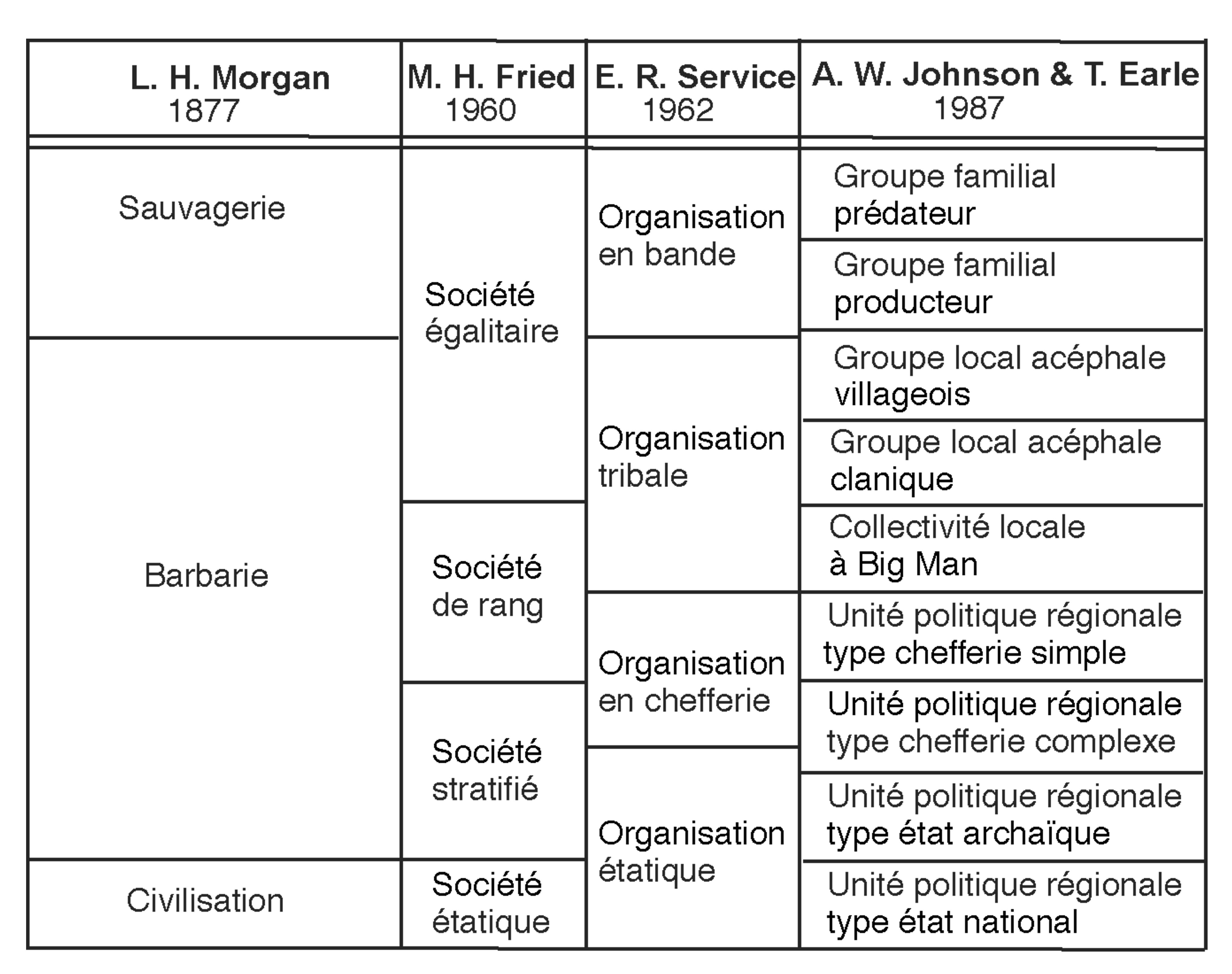
Following the most appropriate current categorisation of types of social organisation, proposed by Johnson and Earle (1987, second edition 2000), most scholars considered Hallstatt societies of the sixth and fifth centuries BC to belong to the complex chiefdom category, whereas among post-processualists it has become more acceptable to see them as local communities of Big Man type (Eggert 1989, 1997), i.e. a markedly less complex form of organisation, in which leaders were not able to exercise coercive power. But the storms of 1989 forced most researchers to “swerve” in their line of thought because traces of Hallstatt D1 occupation were discovered over an area of nearly 100 ha among the uprooted trees around the Heuneburg. Some scholars have even come to conclude that this “princely seat” was a town (Fernández-Götz 2017), which implies that the Heuneburg community was akin to an archaic state, the city and the state being considered consubstantial everywhere (fig. 1).
The consequences of the relativist dead-end
Attracting media attention was not the only reason behind this latest conceptual shift. Adopting a post-modernist approach, which is deeply rooted in relativism, makes it possible to eschew any analytical rigour, since all is a question of perspective, and hence subjective, without even having to define the concepts used. Yet we all know that the notion of a town or of an urban site is invoked for forms of agglomeration of very different periods and regions worldwide; hence it is essential to define what is being compared, as any scientific enquiry demands. This did not the publication in 1997 of a large volume bearing the title Urbanization in the Mediterranean in the ninth to the sixth centuries BC, a telling example of such a way of thinking. Its authors concede that “it is impossible to give a single definition of the term urbanisation” (Damgaard Andersen et al. 1997), being content to discuss the matter in the vaguest of terms, thus condemning themselves to a sterile and unscientific approach, given the impossibility to compare the agglomerated settlements of the time.
Urbanisation: what definition should be adopted?
If we examine the attempts at defining the emergence of the concept of a town in temperate Europe among specialists of recent protohistory, we cannot but conclude that very few have invoked the written record of Greek Antiquity to support their statements. Yet, an interest in defining the town and its corollary, urbanisation, has long preoccupied scholars. Our colleagues in Classical history and archaeology have often had recourse to such sources, although more concerned with the origins of the polis than with that of towns in general.
Pausanias, in an apophatic definition of a marginal case, Panopeus (or Phanopeus), provides a list of the physical characteristics of what he considers urban by noting their absence in the “city” in question, including traits typical of a polis such as political aspects (the Assembly, the seat of the government of Phocis) and symbolic elements (a founding hero myth), as well as more material manifestations of a territorial unit defined by its limits (Pausanias, Periegesis, 10.4.1).
Five centuries before Pausanias, Plato seemingly goes further at a conceptual level in his Critias, outlining criteria for describing the city of Athens and imagining, in a kind of retrospective reconstruction, what Athens may have been like 9000 years earlier. He describes in minute detail the two cities of Athens and Atlantis, the former embodying the excellence and balance provided by permanence, the latter representing the corruption associated with unstable growth. Through Critias’ account, Plato gives pride of place to the concept of the city, listing six descriptive criteria that both define and oppose the two cities. These criteria are anthropogony (referring to the birth of the citizens of a city), ethnography, economy, topography, chorography (relating to geographical aspects of its territory) and finally astugraphy (which concerns the town – astu – proper, its organisation and boundaries) (Kliebenstein & Pineau 2001; Charbit 2002; Pradeau 2010, 170-171). Plato was, as it were, already proposing a methodology and his model is theoretically capable of being applied in archaeology. Each of the philosopher’s headings can be taken as having the value of a prototype, surprisingly modern in approach and inviting us to re-evaluate the contribution of the Classical written sources on the subject of urbanism. The present-day narrow focus and compartmentalization of academic subject areas probably explain why protohistorians have tended to neglect the seminal texts of Antiquity. Be that as it may, even today, the criteria used by archaeologists to qualify an agglomerated settlement as urban continue to be mostly insufficient. Yet, we only need to consult the work of urban geographers to find appropriate criteria. There, a town is defined as having “a high level of density, diversity and centrality” (Lévy & Lussault 2003). The main difficulty thus consists of determining the thresholds that would allow us to consider a settlement as having reached this “high level” according to these three criteria.
What population density?
The average population density of present-day towns is extremely variable, not only worldwide but within each country, even in countries with a strong administrative power such as France. It depends on the areas taken into account, which vary and change at an uneven pace from one town to the other (owed, for example, to the development of out-of-town retail centres or housing estates). The figures quoted are therefore based on administrative boundaries whose limits are defined along fluctuating criteria. In France, the census depends on the boundaries of the communes, which may spill out to a greater or lesser extent over the surrounding countryside. In such cases, the number of inhabitants is more relevant. The minimum population threshold retained to classify an agglomeration among towns also varies greatly by country; in Scandinavia, for example, very small present-day settlements may be called towns because they once fulfilled an administrative role. France is within the average in terms of the urban population density worldwide. As F. Taulelle (2010, 151) writes, “generally, small towns are those with between 3000 and 20 000 inhabitants…” but he notes that several authorities quote a higher minimum threshold of 5000 inhabitants. In archaeology, we obviously do not need to split hairs over average numbers but should retain that a settlement with a population above 5000 inhabitants has a 90% chance of being a town. That was probably the case of the Heuneburg in the middle of the sixth century BC and was likely to have also been the case of Vix around 500 BC. Nevertheless, it is clearly essential to meet the conditions of the other two criteria (diversity and centrality), as they prove to be decisive.
We therefore need to start from demographic criteria, following a good archaeological methodology. To identify a settlement of 5000 inhabitants, which would probably cover a minimum area of 50 hectares in Hallstatt times, requires large-scale open area excavations. The number of inhabitants can, however, be assessed for the sites in question by taking into account the extent of surfaces whose limits are known (e.g. palisades or defensive circuits). There is only one princely seat, the Heuneburg, that has been excavated and surveyed on a sufficiently large scale to give a relatively clear idea of the size of its population. In his attempt at estimating the size of the population of the Heuneburg (i.e. the hillfort, Vorburg or “bailey”, and outer settlement), Siegfried Kurz calculated that the outer settlement may have accommodated 3500 people, based on a figure of 500 dwellings, each with seven individuals per family unit. Adding the Vorburg, the north-eastern terraces and the 3-ha hilltop plateau, the total number of inhabitants would reach around 5000 at the peak of the site’s expansion in the Hallstatt D1 phase (Kurz 2010). Although this figure has been questioned in a recent article by R. Schumann (2019, 171-179), we consider it plausible, as do our colleagues in Baden-Württemberg, who endorse this result for the site’s Hallstatt D1 phase that ended around 530 BC (Krausse et al. 2019) and which was followed by a period that saw most of the buildings outside the hilltop disappear. The massive size and extent of the ramparts of Mont Lassois at Vix, encircling an area of 40/45 hectares, suggest a settlement of similar size (fig. 2).
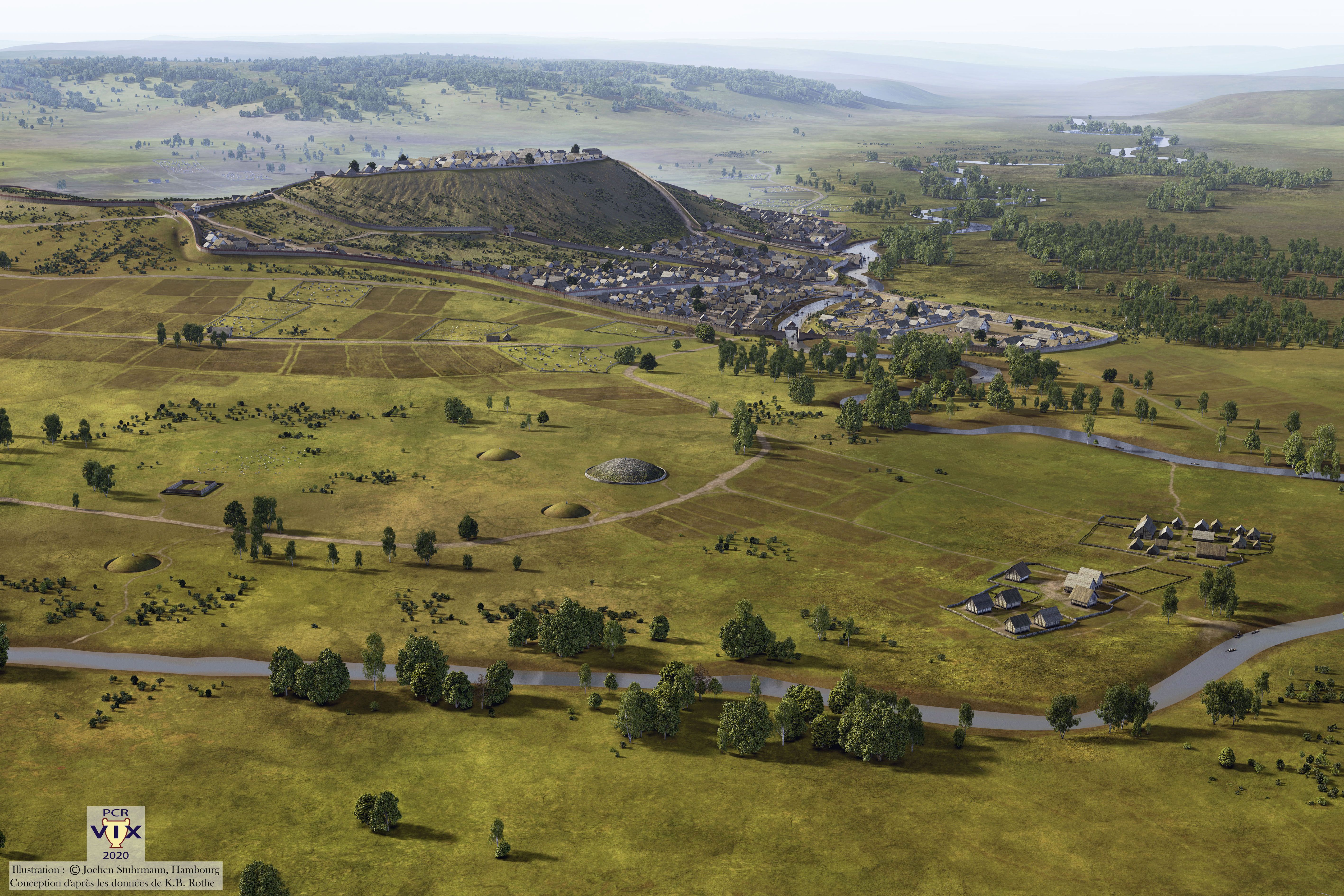
For Vix, an assessment of the entire site and its surroundings is not yet possible. The intra muros settlement of Mont Lassois (essentially the Mont Saint-Marcel and its slopes) occupies an area of 40/45 hectares but, within that space, a number of so far unknown variables makes it difficult to attempt a reliable estimate of the size of its population. The first, and not least, challenge is that we do not know the intensity of occupation on the slopes, which are generally very steep. Of course, it is possible to envisage a tiered settlement established on artificial terraces, but the absence of investigations in these sectors prevents us from reaching any conclusion. As for occupation on the lower slopes, the excavations by the University of Zurich to the north-east of Mont Saint-Marcel have begun to provide some clues by uncovering domestic structures (houses, hearths) established in a terraced zone (Chaume et al. 2021, 7-8, figs. 13-14; Winkler forthcoming).
While an estimate of the size of the total population of Mont Lassois is currently premature, it is possible, on the other hand, to calculate how many people occupied the upper plateau, thanks to the comprehensive plan of this plateau recorded in geophysical surveys by Harald von der Osten-Woldenburg (fig. 3). Based on an average of three households per enclosure and seven people per household, the figure obtained is 300 inhabitants, to which we should add the population accommodated in the five large apsidal buildings (50 individuals in the two largest buildings (nos. 1 and 5), 25 persons for building no. 2, and 15 each in buildings nos. 3 and 4), i.e. a total of some 160 people. This results in a total population of a little under 500 people occupying the upper the plateau of Mont Lassois.

Another way of estimating the size of the population may be appropriate, based on the number of households per hectare rather than by enclosure. Using this criterion and considering the evidence in the southern part of the plateau, each half hectare would contain eight households, i.e. 16 households per hectare. If we multiply this by four (to cover 4 ha), we obtain a figure of 64 households. Assuming that each household comprised 7 individuals, the total comes to 448 inhabitants, to which the 160 people who occupied the large apsidal buildings should be added. The final sum would therefore be 608 inhabitants. Such a figure is entirely compatible with the figures for the Heuneburg. The plateau of the latter site occupies an area of 3 ha, while that of the Mont Lassois covers a surface of 5 ha.
The calculations attempting to estimate the size of the populations of the upper plateaux of Vix/Mont Lassois and the Heuneburg end up with roughly equivalent figures (between 500 and 600 inhabitants), even though the relevant areas differ, i.e. 3 ha for the Heuneburg and 5 ha for Vix. It would follow that, at least on the plateaux, the density of households present on the Heuneburg is greater than that on the Mont Lassois, where the buildings are aligned along a palisade that follows its central street axis, leaving open space between the backs of the houses and the edge of the plateau for vegetable plots or orchards. The debate that has recently arisen around the size of the population at the Heuneburg underlines that we should aim to determine an order of magnitude rather than split hairs over figures, which ultimately are only approximations. As it is, the attempts at quantifying the population of the Heuneburg and most probably also that of Mont Lassois all converge on a figure of between 3 500 and 5 000 inhabitants. In the end, and this seems to be accepted, the figure goes well beyond the numbers envisaged up to now for protohistoric settlements in temperate Europe. The Heuneburg and Mont Lassois thus appear to have met the population density criterion to qualify them as towns, but the situation is different when it comes to the other two criteria.
What thresholds for the other two criteria?
The criterion referring to the diversity of activities, be they political, economic, administrative, military, religious or even poetic, obviously depends on the level of overall development within the time and space under investigation. To gauge this, it must be based on inventories compiled case by case and for activities, such as the various types of crafts (depending on their degree of specialisation), for which the archaeological evidence has best survived. The diversity of activities must also be assessed in relation to the site in its entirety within the period and culture in question. The challenge for our period is that crafts were dependent on the courts; the craftsmen were not engaged in free enterprise. These two forms (court patronage and independent traders) evidently did not have the same socio-economic significance, and by far. Indeed, the exercise of an independent professional activity can only have emerged in an urban milieu, which could not have been the case at the princely seats of the Heuneburg and Mont Lassois, with their emphasis on patronage. This would indicate that these two sites were far from urban when they collapsed.
The fact that the Hallstatt smiths were maintained – not only in terms of board and lodging but also because they were supplied with raw materials by the social elites who commissioned them – goes back to a tradition linked to the emergence of the most specialised crafts, whatever the material. This explains the distance between the good-quality iron ore deposits and the ironworking workshops, the latter located close to the seats of power. It also implies that the quantities of raw material in circulation came from several different, even distant deposits and that iron was available both in its raw state and in the shape of half-products, i.e. bipyramidal bars, as established by Sylvain Bauvais and his team (this volume). Moreover, it emerges that the non-funerary deposits of iron half-products of different geological provenance but of the same shape and weight standards were more than just raw material in transit. Here again, we are seeing a practice rooted in a very long tradition, which involved offering archaic metal currency to the gods, a material strictly controlled by the dominant class when votive or propitiatory offerings were being made. This is evident from the copper objects – torcs, axes and a type of fastening (Spangenbarren) – that acted as a form of currency (Lenerz de Wilde 1995) from the end of the third millennium onwards to the east of the north-alpine region. A similar situation is discernible in the last four centuries BC in a zone that stretches from southern Germany to Britain, involving another type of iron half-product, i.e. bars with curved extremities, the so-called currency bars.
The centrality criterion rests on the position of a settlement at the top of a local network consisting of all the smaller settlements in the region but especially on the top site’s connectivity over longer distances. The latter can be measured as the sum of the distances between it and the other urban agglomerations of a similar or higher level with which the centre of the network in question had frequent exchanges. Such an estimate amounts to measuring a degree of connexion whose threshold can be defined by using network and graph theory (Brun 2017). A strong degree of centrality requires the central site to be at the head of a supra-local, regional or supra-regional network linking all the contemporary settlements within that network. In our case, only two princely seats had reached the required population density threshold, implying that there was no urban network within the zone of the princely phenomenon.
A further criterion should be considered: the persistence of a settlement’s occupation, as attested by the creation of burial grounds in close proximity. We understand this to mean cemeteries in the full sense of the term, i.e. places dedicated to the burial of the majority of the people inhabiting the settlement in question and not the elite cemeteries, ostentatious or not, that have been dominant throughout protohistory, especially during Hallstatt D2/D3 in the zone of the so-called princely seats. We shall return to this question below.
The hypothesis of an incomplete level of urbanisation
We have shown that the centres of power under scrutiny here did not reach an urban level. Although the large agglomerations of the Heuneburg and Mont Lassois most probably met the population density criterion, we should emphasise that the Heuneburg reached a population of around 5000 people only during a few decades in the Hallstatt D1 phase. Workshops dedicated to the highly technical crafts of the time were indeed established there, producing metal objects (of bronze and iron) and pottery (coil-built and wheel-turned) but they were concentrated in the hillfort itself, whose ramparts, in one phase, were built in a striking Mediterranean building technique, featuring thick walls and quadrangular bastions made of mudbrick over carefully made drystone foundations (Kurz 2010). It seems that only craftsmen under the patronage of the court were active on the site, practising highly skilled and varied crafts, whose products were of limited quantity and without direct economic benefit to the rest of the population, as we pointed out in 2013 (Brun & Chaume 2013, 338).
This aspect runs counter to the hypothesis of a variety of activities offering cost advantages when grouped, as is expected from a fully urban configuration. A town is a type of settlement that exploits, at a local level, the proximity, both permanent and temporary, of numerous individuals engaged in very diverse activities, thus saving time and energy, hence literally “agglomeration economies” in all social domains. At a broader level, a town must also belong to a hierarchical network involving other towns. To be sure, an evolution leading towards the beginnings of urbanisation did take place north of the Alps between western Bavaria and eastern Berry, but this trend remained rudimentary and far from complete.
Neither the “princely” phenomenon north of the Alps nor even some of its centres of power can be considered urban. They should also not be seen as proto-urban because the latter concept has a clearly teleological meaning, anticipating an end-result, and is used to describe a process that was deliberately striving towards, and eventually achieving, urban status. Let us note that there is nothing exceptional about the collapse of our large settlements well before they achieved an urban stage, but it occurred more frequently in Mesopotamia and the Mediterranean – as attested by numerous archaeological investigations in these regions – than in temperate Europe. The many inconclusive attempts at urbanisation are symptomatic of a general pattern that often accompanied them, namely the political disintegration of federalist, pre-state coalition initiatives (Gibson 2011). It is therefore imperative to identify sites that did not reach an urban stage, and which are not proto-urban but atelo-urban (from the ancient Greek atélès meaning unfinished) (Brun & Chaume 2013).
Three questions at issue
Among the key questions relevant to our discussion, the following three issues must be addressed:
- Are the “princely” seats at the centre of their regions or not?
- Is the Lavau burial an exception to the rule among the “princely” centres?
- What caused the collapse of these centres?
Are the “princely” seats at the centre of their regions?
What we know about the “princely” centres suggests that at least some could have been located off-centre within their territories, particularly in the case of the Heuneburg during Hallstatt C–D1, and Vix and Bourges during Hallstatt D2–D3. It is of course possible that this is due to the differing intensity of archaeological investigations in the various regions, to the uneven degree of archaeological visibility and recording of the remains, and to the vagaries of agricultural exploitation and development of the infrastructure. The current picture is nevertheless quite unsettling, and the consequences serious enough to warrant reflection.
In his work on the zones of cultural homogeneity in Baden-Württemberg, Oliver Nakoinz has, for example, highlighted most convincingly the border effect between cultural groups through the typology of objects used there and the favoured axes of communications, which he describes as “corridors” linking intercultural nodes within networks, i.e. the “princely” centres (Nakoinz 2010). He stresses that the latter are more often located on the edges of the cultural groups and that the southern sites appear to have lost their regional hold within the long-distance networks at the expense of their counterparts in the north. Nakoinz thus suggests that the gateway model applies to the south-west of Germany.
For the Hallstatt period, the indicators of a decentred network following the Breisach, Hohenasperg, Ipf and Heuneburg corridors also appear to be emerging at Vix and Bourges. The presence of elites has yet to be documented in some areas of the latter two sites’ theoretical territories, as suggested by the application of the Thiessen polygon method. Following Nakoinz, this territorial decentring was, on the one hand, owed to local exchange systems based on kinship becoming largely disconnected from the agropastoral type of economy, and, on the other hand, because the nodes of the long-distance exchange (and hence intercultural) networks were located independently from the earlier centres. In our case, it appears that we are dealing with a configuration, well-known in geography, of “decentred principal seat” type, i.e. a model in which the principal site, supposed to be in the centre, is in fact located close to a territorial limit so that it can respond rapidly to exterior threats or be positioned closer to trading partners.
As the geographer Christian Grataloup (1996) has demonstrated, the most efficient type of organisation consists, a priori, of the command of a social entity being at the centre of its territory. This is why, for example, King Philip II of Spain chose Madrid as its capital. But it turns out that capitals were often off-centre throughout human history. Two major causes, often converging, explain this phenomenon: the first is threat, with notable examples in Constantinople for the Roman Empire and Beijing for the Chinese Empire, both established near the border most vulnerable to attacks.
When a spatial system is strong (with internal cohesive forces greater than external pressures), its centre of gravity a priori occupies a median position, provided that it does not merely have a geometric significance, but a topological sense is ascribed to this centre (in terms of distance-time spent in overland travel or navigation). Conversely, when the power relationship tends towards the reverse, the capital frequently moves towards the most threatened border. This correlates with distances being changed within that space and the parts most distant from the seat of power tending to become more autonomous and more open to external pressures. Such a model, if it has a claim to general validity, could be dubbed the ‘Constantinople principle‘ (Grataloup 1996, 27 and 30, own translation).
The second cause is the necessity to control the entry point of the principal consignments of foreign goods into a territory; this makes it also a locale where the concentration of wealth is particularly attractive, especially for plunder (fig. 4). London and Paris, both decentred capitals, are examples of responses to these constraints.

The possibility that princely “centres” had exercised their centralising power while located near their most exposed borders to protect themselves militarily and/or to control the import/export of goods creates a methodological challenge. It would obviously make the Thiessen polygon method invalid. This methods aims to express the thickening of a theoretical territory by positing that centres of similar importance tend to polarise the space nearest to them. Strongly bound by the idea of economies of distance, this principle can be countermanded for various political, economic and/or ideological reasons, as we have seen. This does not, however, mean that the Thiessen polygon method has no value. The overall thickening brought to light by this method is likely to be a good indication of the size of a polarised territory, even if its limits are only approximate. Moreover, evaluating the size of a given territory clearly depends on how many central sites are known and on how numerous they are, their size being reduced the more centres of similar date and status are taken into account. It allows us to apprehend, with all due caution, the extent of delimited territories and to draw the most likely conclusions from this exercise.
The Lavau burial: an exception to the rule?
Discovered in 2015 on the north-eastern edge of Troyes, the princely burial of Lavau has been presented as a counterexample of Wolfgang Kimmig’s (1969) princely seat model because no nearby hillfort can be found or even envisaged in the vicinity. Kimmig had initially proposed four criteria for defining princely seats, namely:
- The presence of an acropolis, of a suburb and of artisan quarters
- The presence of Mediterranean – and other – imports and local imitations
- The presence of wealthy tombs in the vicinity
- A location on an important node of communication routes, notably along rivers.
Since the Heuneburg is the only site to have been excavated on a sufficiently large scale, the first criterion (population) cannot be verified for the other likely sites. Kimmig was well aware of this, and only retained three criteria in his more recent work (Kimmig 1991), namely:
- A location on a major natural route
- The presence of princely tombs in the immediate vicinity
- The presence of Mediterranean objects.
If we follow the canonical model, the fortified character of the princely seats is no longer an essential prerequisite for a princely centre in the south-western part of the north-alpine cultural complex. Admittedly, most of the known princely seats other than the Heuneburg had ramparts, but the latter are not in themselves representative of the political entities in question. They are an archaeological feature that is purely morphological, not a structural element that is essential for their existence. It is highly likely that the communities under investigation were endemically engaged in armed conflicts and therefore intent on protecting themselves. Yet many protohistoric societies, although bellicose, did not have the means or the time to erect ramparts.
Let us return to the political entity that buried in flamboyant style a member of the local ruling dynasty at Lavau. One of us (Chaume 2001) had proposed that the site linked with the aristocratic burials in the region of Troyes was located under the present-day town,1 since there was obviously no hillfort; indeed, there is no high ground to speak of in the neighbourhood of this confluence site, except, perhaps, at l’Isle Aumont (Demoule 1997, 309, fig. 6); the latter site, however, appears too modest to have held such a position, both in terms of its area (around one hectare) and its height asl.
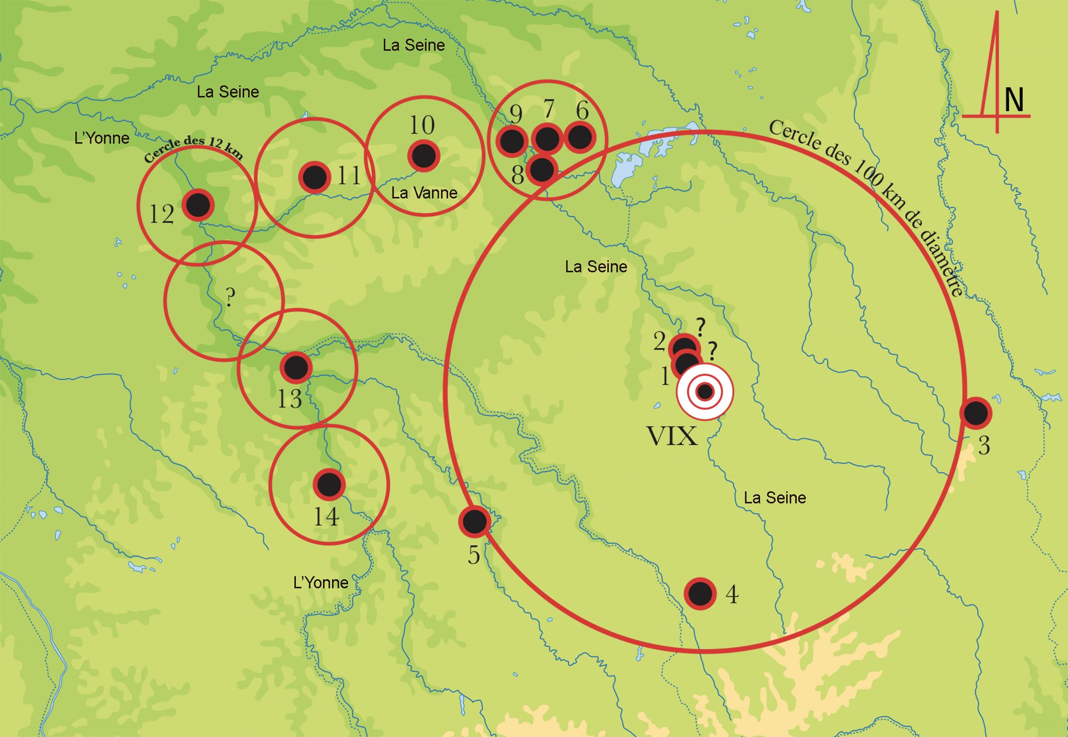
It is not inconceivable that the collapse of the “Celtic principalities” was accompanied at the beginning of the later Iron Age, and probably in the period of transition between the Early and Later Iron Age, by a power grab by vassal groups that formerly served as politico-economic relay points for the potentates who controlled the princely seats. In the region of Troyes, which is located at the northern edge of a circle 50 km in radius centred on Mont Lassois, the presence of very wealthy burials dated to the transition period from Hallstatt to La Tène indicates the emergence or the development of a new aristocracy taking over, alongside all or part of the authority, the control over communication routes and imposing itself as obligatory mediators in the trade relationships with Marseille on the one hand and northern Italy (notably the Golasecca culture) on the other (Brun 1997, fig. 7).
The implosion of the aristocratic powers at the end of the Early Iron Age would explain a return to the control of smaller territories by the elites at the beginning of the later Iron Age; this smaller scale, i.e. an area some 25 km in radius around a central site is characteristic of simple chiefdoms (fig. 5). Such a model of territorial organisation, applied to the region of Vix, Troyes and the valley of the Vanne, has been presented by one of us (Chaume 2001, 350, 351, fig. 232). The hypothesis was taken up by Luc Baray in 2013 (Baray & Sarrazin 2013, 8, 9, fig. 4, B) and more recently by Bastien Dubuis and Vincent Riquier (Dubuis & Riquier 2018, 232, fig. 9) but without referring to the original source.
There are indeed some reasons for thinking that a princely seat may well have been established on the site of the present-day city of Troyes, in the vastly enlarged valley of the Seine. It is there that the river is joined by several affluents, and the site is consequently naturally very marshy. Such a location would make it possible to benefit from a hydrological milieu that was both favourable to trade by waterways and a deterrent to concerted attacks.
At a regional scale, the putative princely centre near the tumulus burial of Lavau would be located at the northern edge of the south-western north-alpine cultural complex – which saw the flourishing of princely societies that had very favourable exchange relationships with the Greek and Etruscan city-states – and to the south of the Aisne-Marne culture. The latter forms part of the same cultural complex but differs in its material culture and has not yielded any large, fortified settlements or burials as conspicuously furnished as the so-called princely burials further south. It therefore seems that, far from being an exception to Kimmig’s standard model, the evidence keeps pointing to its overall relevance.
The magnificent Lavau burial has all the hallmarks of a princely burial, including a wealth of Mediterranean imports, particularly Etruscan, deposited there. The initial morphometric analysis of its skeleton has identified a male individual, but the person is more likely to be a woman, judging by similar burials, of which more than half are female. The absence of weapons and the types of objects of personal adornment would tend to support this hypothesis. The assemblage is dated to the transition from Hallstatt to La Tène, around 450 BC, i.e. the time of the implosion of the princely phenomenon and of the collapse of the princely seat at Vix/Mont Lassois.
In this transitional phase, the cultural elements appear more aligned on the Aisne-Marne culture and include two-wheeled chariot burials roughly contemporary with earlier discoveries made in the area of Troyes, and perhaps even a lowland settlement. These elements all suggest that the most likely interpretation of this phase of transformation is that it was a spatial, cultural as well as temporal transition, a view that could endorse the process proposed by Kimmig.
Going beyond the limitations of local analysis or too narrowly specialised subject areas such as the study of funerary assemblages or biological remains, let us stress that funerary practice, although imbued with obscure meaning, is integrated with other social dimensions. This contradicts the post-processualist view that there are innumerable meanings that escape our comprehension; myriad signals that are unpredictable and which we can merely describe without any hope of explaining at a more general level. Yet it is possible to extract some structural meaning related to the more or less ostentatious nature of the power in place and the more or less intensive degree of exchange that took place. The custom of holding banquets was a common trait of the north-alpine social elites since at least the fourteenth century BC. In all the burials excavated, the abundance and/or luxury of the vessels recovered signals the importance the banquets had for the social elite buried with great pomp; it obviously symbolised the funerary feast but, more generally, the banquet was a key element in the politics of power. High-ranking individuals entertained lavishly, offering, in diverse circumstances, food and drink to project an image of conviviality, solidarity, sociability, generosity, and to show off their wealth, power, good fortune and divine protection; in other words, stating their legitimacy.
The written and ethnographic sources show how universal such practices are among hierarchised societies and the multiplicity of occasions for organising spectacular feasts, e.g. births, rites of passage to adulthood, marriages, military victories, changes in status, collective enterprises, funerals etc. (Hayden & Dietler 2001). At funerary ceremonies, the mourners close to the deceased showed that they were capable and willing to take on his or her role as political and religious leader. The ceremony itself was used to send a message, thus transforming it into a vast operation designed to communicate that intention to the local population but also, most probably, to invited foreign potentates. The cost was justified, not just to win the favour of those taking part in the feast and temporarily impress them, but also to leave a lasting mark in the memory and on the landscape.
It is likely that the outlay was the greater, the more unstable or threatened the position of the leading family was, i.e. during periods of economic difficulties and political challenges, particularly in territories controlling communication routes or through which large quantities of goods, people and ideas passed; while such situations were beneficial to increasing both material and intellectual wealth, they were potentially also always likely to upset the traditional social order (Brun et al. 2010)). Indeed, material growth always seems to change the social balance and new ideas inevitably disrupt the status quo.
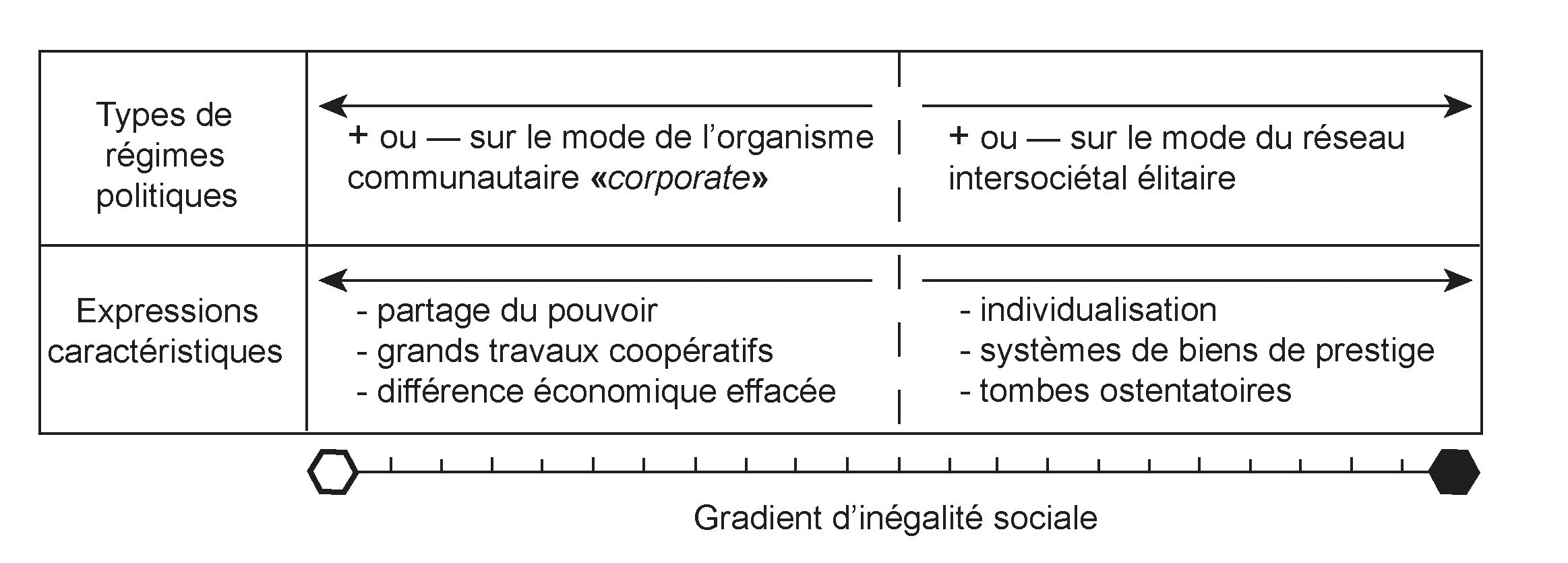
This perspective fits the “dual-processual” approach of Richard Blanton (Blanton et al. 1996). This theory posits that leaders employed different types of political-economic strategies on a scale ranging from exclusive and very centralised “network strategies” to “corporate strategies”, defined as community-oriented, inclusive and much more decentralised. The “network” mode stresses personal prestige, the exchange of wealth, an individual’s power to accumulate riches, the rise in social status, inheritance based on lineage and descendance, individualised ideologies, personal networks and specialised craftspeople and workshops. Archaeologically, the evidence consists of indicators of the individualisation of power, luxury goods exchange systems, and conspicuous burial. The “corporate” mode emphasises basic food production, communal rituals, public works, power sharing, large community projects, with the various social elements connected by ideological means and by rituals designed to promote integration. Although a hierarchy is present, it is less individualised, and the economic inequality is reduced, more muted in its funerary practices in particular (Brun 2018) (fig. 6). The princely phenomenon is a quasi-textbook example of a network strategy materialised in the monumentality and wealth of its burials; it represents a swing towards ostentation that is most likely to express the political regime’s marked tendency towards despotism. It is this type of regime that collapsed, giving way to more restrained funerary practices and a political regime that gave greater power to local communities, especially to the heads of clans or lineages.
The causes of the collapse of the “princely” phenomenon
The question of the causes of the collapse of the north-alpine princely phenomenon had been discussed at the 1993 Chatillon-sur-Seine colloquium (Brun & Chaume 1997). The most interesting aspect of this discussion was the recognition that this collapse was indeed a general breakdown of all the societies that had followed this trend and that it was therefore also owed to one or several universal causes. We had outlined three kinds of scenarios:
- a) an internal crisis, including social conflict and/or an inability on the part of the elites to manage growth (over-exploited peasantry, despotism);
- b) a crisis outside the princely seats but within the Celtic zone, involving conflict between principalities and less hierarchised peripheries (wars);
- c) an external crisis, caused by a shift in economic demand or a change in scale of the overall system (the princes becoming too demanding).
The new data from surveys, excavations and various analyses conducted on the burials and settlements under investigation, and a widening of perspectives involving comparison with similar societies elsewhere in the world, namely complex chiefdoms, lead us to propose a multi-causal explanation (see alternatives a) to c) above). Our Hallstatt communities, which may have started as a coalition of three or four simple chiefdoms to become complex chiefdoms led by dynasties over three to five generations, benefited from intercultural exchange networks stimulated by the Greek and Etruscan city-states which enabled them to increase their wealth and power.
These dynasties are likely to have exercised their power in an authoritarian or even despotic manner, as attested by the hyper-conspicuous character of their funerary practices, which may have been crushing for the ordinary population. Moreover, the ruling families probably feared losing their power outside the family, to the extent that women could take on that power on the death of the leader – in particular as regents when a male heir had not yet come of age – thus ensuring that supremacy was not intercepted by a rival family. The term “honorary male syndrome” has been coined by Antonia Fraser to describe such a situation, meaning, in a figurative sense, a set of signs and behaviours that reveal a mindset, a way of thinking and acting shown by a person, group or community and attested by several examples of such situations recorded since Antiquity (Fraser 1989). The example of Artemisia I, queen of Halicarnassus in Greece at the beginning of the fifth century BC, and therefore a contemporary of the “Lady of Vix”, is significant. In this context, Bettina Arnold (1995) has taken up the idea, discussing the gender, status and power displayed in the numerous ostentatious burials of women recovered in the zone of princely burials.
Our despotic dynasties were competing with neighbouring dynasties of similar status, following the relationship defined as “peer polities”, namely politically equal entities or societies of similar rank, described by Colin Renfrew and John Cherry (1986). The relationship was one of competitive emulation, involving gifts, reciprocal gifts, ceremonial exchange (ostentatious giving of prestige goods for diplomatic and matrimonial purposes among the elites) and imitations of monumental structures (e.g. burial chambers under barrows whose basic structures are tellingly similar). It also involved wars that were nothing other than a competition to obtain territorial gain or plundering raids to acquire valuable goods and/or prisoners to sell or keep as slaves, as evidenced by repeated attacks on fortified sites. In addition, it included the transmission of innovations from other, more advanced societies; new techniques (wheel-turned pottery, bloomery furnaces, perhaps also military organisation), knowledge of the world (geography, ethnography, art, mythology), not to mention the movement of commodities, i.e. organic or metallic raw materials and slaves that underpinned the Mediterranean world system (Brun 1987) exchanged for prestige items such as the Vix crater, the Sainte-Colombe-sur-Seine cauldron, the Grächwil hydria or the mudbrick ramparts of the Heuneburg and Mont Lassois (Chaume 2020a, 2020b).
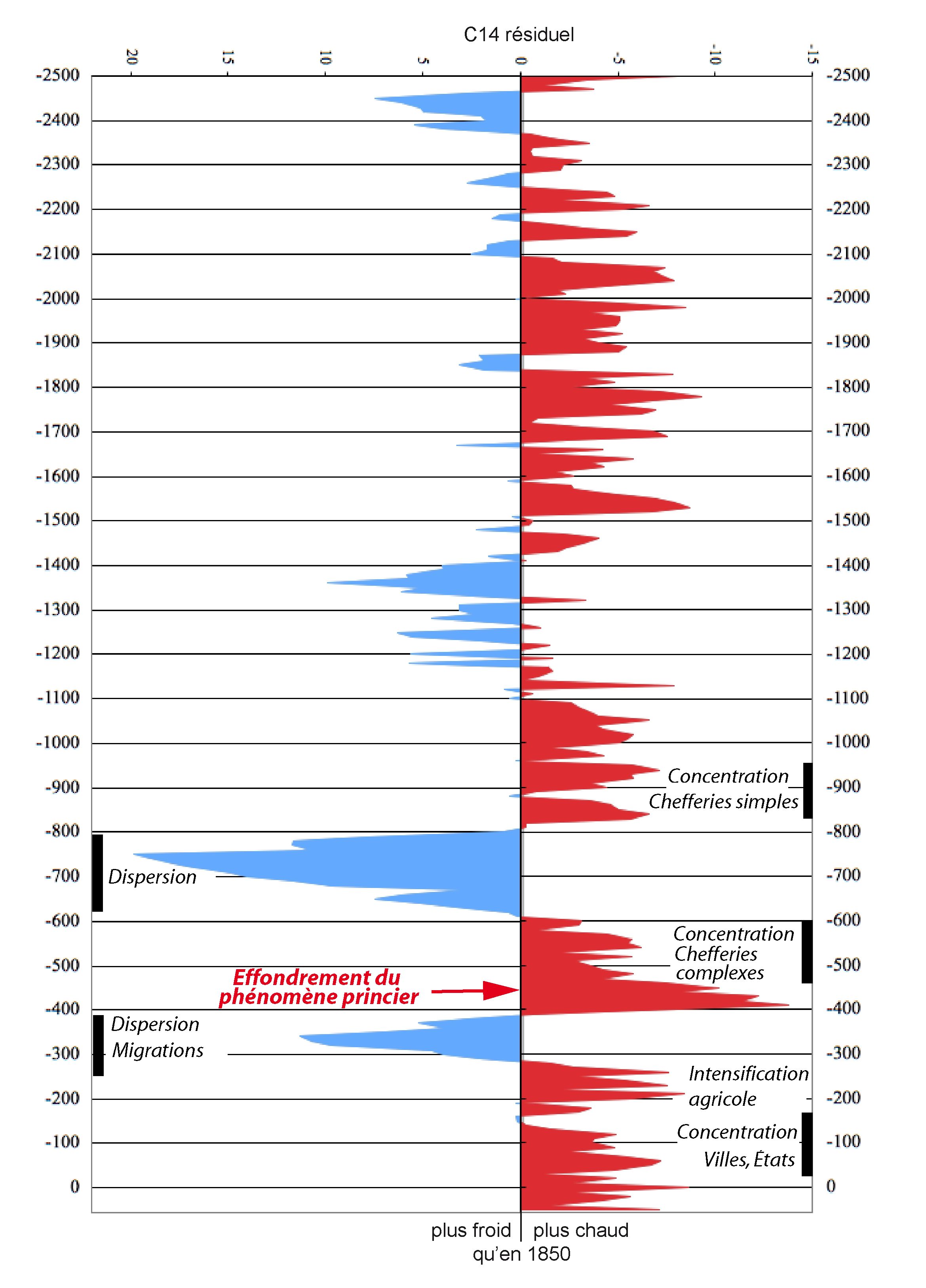
The economy of these complex chiefdoms was based on agropastoralism, whose productivity had not changed since the end of the local Bronze Age. It was unable to meet the needs of large agglomerations over sustained periods, which meant coping with the fluctuations of a climate that could be both markedly colder and wetter and hotter and drier. Such irregularities soon tested the fragile agricultural economy and its peasantry; the latter, badly fed and perhaps unduly drained of its workforce or subjected to too much forced labour, was likely to revolt against the elites, perceived as incompetent and tyrannical. At any rate, this is what the climate curve of residual 14C suggests (Brun & Ruby 2008), as do cores taken from glaciers, apparently correlating with wider trends such as the collapse of the north-alpine princely phenomenon (fig. 7).
These important and numerous new data add weight and detail to the social model proposed by Kimmig, strengthening a model mistakenly denied by the proponents of post-processualism, reinforcing it instead thanks to the more systematic approach adopted by a number of researchers, including the authors of this article. To achieve such a systemic contextualisation, the key methodological procedures employed in our approach consist of quantifying the frequency of associations and comparing the processes involved. Even better, thanks to theoretical concepts such as the dual-processual model outlined above, it has become possible to bring to light different types of politico-economic strategies, from the most inclusive, decentralised and democratic under a community-oriented regime to the most exclusive, centralised and despotic under a network-based regime.
Our “princely” societies, which grew from a strategy of building networks over long distances, probably came very close to the most extreme stage of centralisation and despotism that a non-state and non-urban society could achieve. They failed comprehensively. A theoretical approach, which introduces a crucial parameter for understanding social evolution – namely the types of political regimes – allows us to better interpret the archaeological evidence. Adding the concept of political regimes to the equation, sometimes touched on but never anchored in concrete elements, makes it possible to finally plug the principal gap in the existing social typologies based on forms of social organisation. Quite obviously, all politically autonomous entities had leaders who were more or less authoritarian, especially when invested with coercive power. Their manner of ruling becomes more intelligible if funerary practices and domestic contexts are considered from the perspective of a dual-processualist theory. This is the principle that throws a sharp new light on the remains of the complex chiefdoms examined in the present volume.
References
- Arnold, B. (1995) : “Honorary males or women of substance? Gender, status, and power in Iron-Age Europe”, Journal of European Archaeology, 3, 2, 153-168.
- Baray, L. et Sarrazin, J.-P. (2013) : “La sépulture à char de la Tène A ancienne des “Craises” à Molinons (Yonne)”, RAE, 62, 5-52.
- Binford, S. R. et Binford, L. R., éd. (1968) : New Perspectives in Archaeology, Chicago.
- civilization”, Current Anthropology, 37, 1-14, 65-68.
- Brun, P. (1987) : Princes et princesses de la Celtique, le Premier Age du Fer (850-450 av. J.-C.), Paris.
- Brun, P. (2017) : “L’étude des réseaux à partir des données archéologiques”, in : Dan et al. 2017, 295-343. [en ligne] https://www.persee.fr/doc/dha_0755-7256_2017_num_43_1_4605 [consulté le 5 juin 2021].
- Brun, P. (2018) : “Funerary practices”, in : Haselgrove et al., éd. 2018, [en ligne] https://doi.org/10.1093/oxfordhb/9780199696826.013.8 [consulté le 5 juin 2021].
- Brun, P., Aubry, L, Galinand, C., Pennors, F., Quenol, V., Ruby, P. (2010) : “Elite and prestige goods during the early and middle Bronze Age in France”, in : Meller & Bertemes, éd. 2010, 199-206.
- Brun, P. et Chaume, B., dir. (1997) : Vix et les éphémères principautés celtiques. Les VIe-Ve siècles av. J.-C. en Europe centre-occidentale. Actes du colloque international de Châtillon-sur-Seine, octobre 1993, Paris.
- Brun, P. et Chaume, B. (2013) : “Une éphémère tentative d’urbanisation en Europe centre-occidentale durant les VIe et Ve siècles av. J.-C. ?” Bulletin de la Société Préhistorique Française, 110, 2, 319-349.
- Brun, P. et Ruby, P. (2008) : L’âge du Fer en France. Premières villes, premiers États celtiques, Paris.
- Cailly, L., éd. (2010) : La France, une géographie urbaine, Paris.
- Charbit, Y. 2002. La cité platonicienne : histoire et utopie. Population, 2002/2, 57, 231-260.
- Chaume, B. (2001) : Vix et son territoire à l’âge du Fer. Fouilles du mont Lassois et environnement du site princier, Protohistoire européenne 6, Montagnac.
- Chaume, B. (2020a) : “Vix: The Temptation of the City’, in : Zamboni et al., éd. 2020, 349-360.
- Chaume, B., avec la collab. de Paul Cheetham, Rainer Komp, Friedrich Lüth, Thomas Pertlwieser, Walter Reinhard, Otto Urban et Michael Weissl (2020b) : “Vix et l’émergence des principautés celtiques : l’hypothèse portuaire et le concept de port of trade”, in : Mouchard & Guitton, dir. 2020, 435-452, [en ligne] https://journals.openedition.org/gallia/5394 [consulté le 20 juin 2021].
- Chaume, B., dir. (à paraître) : Le complexe aristocratique de Vix/le mont Lassois (fouilles 2011-2017) : synthèses et habitat, vol. 1, Ausonius Mémoires, Bordeaux.
- Chaume, B., Ballmer, A., Della Casa, P., Nieszery, N., Pertlwieser, T., Reinhard, W., Schäppi, K., Urban, O. et Winckler, A. (2021) : “Entre l’État et la chefferie simple: le complexe aristocratique de Vix/le mont Lassois”, in : Brun et al. 2021, 19-38.
- Clarke, D. L. (1968) : Analytical Archaeology, Londres.
- Dan, A. et al. (2017) : “Les concepts en sciences de l’Antiquité : mode d’emploi. Chronique 2017 – Réseaux, connectivité, graphes. 1. Les espaces, les rets et les rites”, Dialogues d’histoire ancienne 2017/1, (43/1).
- Damgaard Andersen, D.H., Horsnæs, H.W., Houby-Nielsen, S. et Rathje, A. (1997) : Urbanization in the Mediterranean in the Ninth to Sixth Centuries BC, 7 éd., Copenhagen.
- Deborde, G. et Gry, P. (2015) : Troyes : naissance d’une cité, Reims.
- Demoule, J.-P. (1997) : “De la périphérie au centre : la culture Aisne-Marne”, in : Brun & Chaume, éd. 1997.
- Dohrmann, N. et Riquier, V., dir. (2018) : Archéologie dans l’Aube. Des premiers paysans au prince de Lavau (5300 à 450 avant notre ère), catalogue d’exposition, mai-déc. 2018/avril-sept. 2019, Département de l’Aube-Inrap, Gand.
- Dubuis, B. et Riquier, V. (2018) : “Y a-t-il un centre politique hallstattien dans l’espace Aubois ? La question du pôle aristocratique de la plaine de Troyes et son contexte régional”, in : Dohrmann & Riquier 2018, 222-233.
- Eggert, M. K. H. (1989) : “Die ‚Fürstensitze‘ der Späthallstattzeit”, Bemerkungen zu einem archäologischen Konstrukt. Hammaburg, 9, 53-66.
- Eggert, M. K. H. (1989) : “Le concept de Fürstensitz et autres problèmes d’interprétation : annotations sur le ‘phénomène princier’ du Hallstatt final”, in : Brun & Chaume, dir. 1989, 287-294.
- Fernández-Götz, M. (2017) : “Urbanization in Iron Age Europe: trajectories, patterns, and social dynamics”, Journal of Archaeological Research, 26, 117-162, [en ligne] https://link.springer.com/article/10.1007/s10814-017-9107-1 [consulté le 5 juin 2021].
- Krausse, D., Fernándes-Götz, M. Gutekunst, A. et Hansen, L. (2019) : “Size matters – A re-evaluation of the Heuneburg demography”, Germania, 97, 179-189, [en ligne] https://journals.ub.uni-heidelberg.de/index.php/germania/article/view/78621 [consulté le 5 juin 2021].
- Gibson, D. B. (2011) : “Chiefdom confederacies and state origins”, Social Evolution & History, 10.1, 215-233.
- Grataloup, C. (1996) : Lieux d’histoire. Essai de géohistoire systématique, Montpellier.
- Hayden, B. et Dietler, M., éd. (2001) : Feasts: Archaeological and Ethnographic Perspectives on Food, Politics, and Power. Washington (Smithonian series in archaeological inquiry).
- Haselgrove, C., Rebay-Salisbury, K. et Wells, P. S., éd. (2018) : Oxford Handbook of the European Iron Age, Oxford.
- Hodder, I. (1982) : Symbols in Action, Cambridge.
- Johnson, A. W. et Earle, T. (1987) : The Evolution of Human Societies, Stanford.
- Kimmig, W. (1969) : “Zum Problem späthallstättischer Adelssitze”, in : Otto & Hermann, éd. 1969, 95-113.
- Kimmig, W. (1991) : “La forteresse de la Heuneburg et les tombes princières du haut Danube”, in : Moscatti et al., éd. 1991, 114-115.
- Kliebenstein, G. et Pineau, G. (2001) : “Queneau et la ‘poligraphie’”, Poétique, 126, 191-216.
- Krausse, D. et Beilharz, D., éd. (2010) : Fürstensitze und Zentralorte der frühen Kelten, Abschlußkolloquium des DFG-Schwerpunktprogramms 1171, FuBerBadWürt, 120, Stuttgart.
- Kurz, S. (2010) : “Zur Genese und Entwicklung der Heuneburg in der späten Hallstattzeit”, in : Krausse & Beilharz, éd. 2010, 239-256.
- Lenerz-de Wilde, M. (1995) : Prämonetäre Zahlungsmittel in der Kupfer- und Bronzezeit Mittel-europas, Fundberichte aus Baden-Württemberg 20, 229–327.
- Lévy, J. et Lussault, M. (2003) : Dictionnaire de la géographie et de l’espace des sociétés, Paris.
- Meller, H. et Bertemes, F., éd. (2010) : Der Griff nach den Sternen. Wie Europas Eliten zu Macht und Reichtum Kamen, International Symposium (16-21 02-2005), Halle.
- Moscatti et al., éd. (1991) : Les Celtes. Exhibition catalogue, Milan.
- Mouchard, J. et Guitton, D. (2020) : Les ports romains dans l’arc atlantique et les eaux intérieures, Actes du colloque international d’archéologie portuaire, Nantes 21-22 juin 2018, Gallia, 77-1, [en ligne] https://journals.openedition.org/gallia/5256 [consulté le 21 juin 2021].
- Nakoinz, O. (2010) : “Kulturelle Räume der älteren Eisenzeit in Südwestdeutschland”, in : Krausse & Beilharz, éd. 2010, 317-332.
- Otto, K. et Hermann, H., éd. (1969) : Siedlung Burg und Stadt. Studien zu ihren Anfängen: Festschrift für Paul Grimm, Schriften der Sektion für Vor- und Frühgeschichte 25, Berlin.
- Pradeau, J.-F. (2010) : Platon et la cité (2e éd.), Paris.
- Renfrew, C. et Cherry, J.-F.., éd. (1986) : Peer Polity interaction and socio-political Change, Cambridge – New York.
- Schumann, R. (2019) : “5000 Heuneburgians? A critical evaluation of the estimated population size of the exceptional early Iron Age settlement complex of the Heuneburg”, Germania, 97, 171-179
- Taulelle, F. (2010) : “Chapitre 8 – La France des villes petites et moyennes”, in : Cailly, éd. 2010, 149-168.
- Winkler, A. (à paraître) : “Vix/Les Renards : campagnes 2013 à 2016, Université de Zurich”, in : Chaume, dir. à paraître.
- Zamboni, L., Fernández-Götz, M. et Metzner-Nebelsick, C., éd. (2020) : Crossing the Alps. Early Urbanism between Northern Italy and Central Europe (900-400 BC), Acts of the International Conference of Milan (29-30 March 2019), Leiden.